Advertisements
Advertisements
Describe the latitudinal and longitudinal extent of India and Brazil.
Concept: undefined > undefined
India’s southernmost point is known as ______.
Concept: undefined > undefined
Advertisements
Both the countries have ______ type of government.
Concept: undefined > undefined
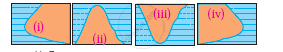
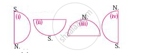
Which of the following shapes show the coastal part of India correctly?
Concept: undefined > undefined
Considering hemisphere, which shape correctly represents the hemisphere in which India lies?
Concept: undefined > undefined
Like Brazil, India too has ______.
Concept: undefined > undefined
To the foothills of the Aravalis ______.
Concept: undefined > undefined
What measures are being taken to control pollution in the rivers of India?
Concept: undefined > undefined
Explain the characteristics of the North Indian Plains.
Concept: undefined > undefined
What could be the reasons behind the formation of swamps in the extensive continental location of Pantanal?
Concept: undefined > undefined
Which are the major water divides of India giving examples.
Concept: undefined > undefined
Write a note on
Himalayas
Concept: undefined > undefined
Write note on
The Indian peninsula
Concept: undefined > undefined
Write geographical reason
There are dissimilarities between the eastern and western coasts of India.
Concept: undefined > undefined
Identify the correct group.
The order of plateaus of India from south to north.
Concept: undefined > undefined
Look at the digital elevated model (DEM) of India and name the major physiographic divisions.

Concept: undefined > undefined
On the basis of Fig, answer the following questions:

- In which direction does the region with an altitude of more than 6000m lie in India ?
- Look for the south-flowing river in the peninsular region. In which river basin does it lie?
- In which direction is the slope of the region in the north shown in dark green?
- Make a list of plateaus located in between Aravali ranges and Chhota Nagpur Plateau.
- Name the peak shown in the Eastern Ghats
- Which mountains demarcate the deep plains of Brahmaputra?
- In which direction does the height of the Sahyadri hills increase?
- The Vindhyas act as water divide between which two river basins?
- In which direction do the Aravalis lie?
- Aravali ranges act as a water divide between which rivers?
- Name the hills located on the plateaus to the east of Aravalis.
- Across which states have the Deccan Plateau spread?
- Give the relative location of the Nilgiri Hills.
- Which hill ranges lie to the west of the Deccan Plateau?
- Enumerate the characteristics of the Western Ghats.
- Compare the Eastern and the Western Ghats.
- Why are the Western Ghats called a water divide?
Concept: undefined > undefined
Write the names of the States/Regions in appropriate columns :
Bihar, Tocantins, Pernambuco, Alagoas, Eastern Maharastra, Western part of Rajasthan, Gujarat, Rio Grande Do Norte, Paraiba, Western Ghats, Eastern Himalayas, Western Andhra Pradesh, Roraima, Amazonas, West Bengal, Roraima, Rio Grande do Sul, Santa Catarina, Goa.
| State | India | Brazil |
| High rainfall | ||
| Moderate rainfall | ||
| Low rainfall |
Concept: undefined > undefined
State whether right or wrong. Rewrite the wrong sentence.
The fact that Brazil lies on the equator affects its climate in a big way.
Concept: undefined > undefined
State whether right or wrong. Rewrite the wrong sentence.
India and Brazil have the same seasons at the same time.
Concept: undefined > undefined
