Advertisements
Advertisements
Question
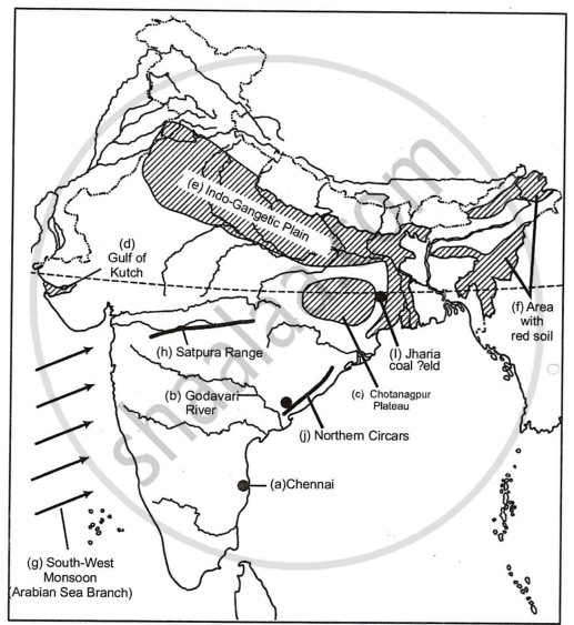
On the outline map of India provided:
(a) Mark and name Chennai
(b) Label the river Godavari
(c) Shade and label the Chhota Nagpur Plateau
(d) Shade and name the Gulf of Kachchh
(e) Mark and name the Indo-Gangetic Plains
(f) Shade and label an area with Red Soil
(g) Mark and name the winds which bring rain to Mumbai in July and August
(h) Mark and name the Satpura Range
(i) Mark and name the Jharia Coal Field
(j) Shade and label the Northern Circar coastal region
Solution 1

Solution 2
RELATED QUESTIONS
On an outline map of India provided:
(a) Draw and name the Tropic of Cancer.
(b) Label the river Godavari.
(c) Mark and name the Garo Hills.
(d) Mark C on the coal fields of Jharia.
(e) Mark with an arrow and name the NE monsoon over the Bay of Bengal.
(f) Shade and name the Gulf of Kutch.
(g) Shade and name the coastal plain that receives rainfall in October and November.
(h) Mark with a dot and name Delhi.
(i) Shade a region with Black Cotton Soil.
(j) Use an arrow to point at a densely populated state in South India.
On the outline map of India provided:
a) Mark and name the Nilgiris.
b) Shade and label the Malwa Plateau.
c) Shade and label the Malabar Coastal Plains.
d) Mark and name the River Gomati.
e) Mark and name the Andaman Sea.
f) Mark and name Allahabad.
g) Mark with a single arrow and name the winds that bring winter rains to North West India.
h) Mark and name Digboi.
i) Mark an area with laterite soil below the Tropic of Cancer.
j) Mark and name the Karakoram Pass.
What is the value of the contour line in square 0226? What is the contour interval in the map?
Mention any two factors which provide evidence that the region in the map extract is a rural region.
Name two features which makes Dantrai a more important settlement than the other settlement in the map extract.
Calculate the area of the region which lies to the south of northing 21 in square kilometres.
What is the geographical name that you would give to the general pattern of settlement in the region shown on the map?
By what name is the parallel of latitude 23° 33′ known? Name the zones or belts into which it divides India almost equally.
Why is the Pamir Knot known as ‘the roof of the world’.
On the outline map of India provided:
- Shade and label an area of alluvial soil in the north-east.
- Mark using a dot and name the commercial capital of India.
- Mark and name the highest peak of the Himalayas in India.
- Shade and label Gulf of Kutch.
- Mark with arrows and name the wind bringing rainfall to Punjab in the winter.
- Shade and label a sparsely populated area.
- Mark and label Eastern Ghats.
- Mark and name a tributary of an important peninsular river.
- Mark and label the most important latitude passing through the country.
- Mark and label Coromandel coast.
