Advertisements
Advertisements
Question
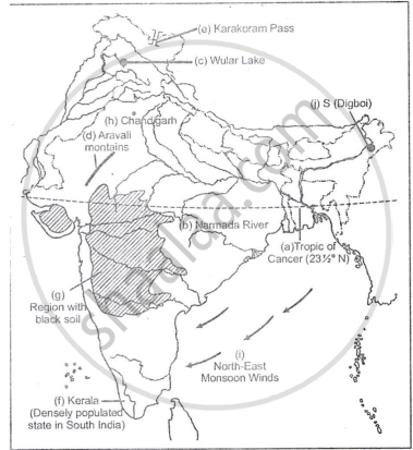
On the outline map of India provided:
- Draw, name and number the Tropic of Cance
- Label the river Narmada
- Shade and name Lake Chilka
- Shade and name Wular lake.
- Mark and name the Aravali Mountains
- Mark and name the Karakoram Pass
- Shade and name a densely populated state in South India
- Shade and name a region with black soil
- Mark with a dot and name Srinagar
- Mark with a dot and name Chandigarh
- Mark and name the winds which bring rain in winter to the Coromandel Coast
- Name and print O on an oilfield in North-east India.
Solution 1

Solution 2
RELATED QUESTIONS
On the outline map of India provided:
(a) Shade and label Thar Desert.
(b) Label the river Narmada.
(c) Shade and name the Wular Lake.
(d) Shade and label Kanara coast.
(e) Mark and name Mount Kanchenjunga.
(f) Shade and label a densely-populated region in India.
(g) Shade and label a region with Red soil in India.
(h) Mark with a dot and name Chennai.
(i) Mark and label the Arabian Sea branch of S.W. Monsoon.
(j) Mark with a dot and name Singhbhum.
On the outline map of India provided:
(a) Draw and number the Standard Meridian of India.
(b) Label the river Mahanadi.
(c) Mark and name Lake Chilka.
(d) Shade and name the Gulf of Mannar.
(e) Mark and name the Vindhya Mountains.
(f) Shade and name a sparsely populated region in western India
(g) Shade a region with alluvial soil in South India.
(h) Mark and name Kolkata.
(i) Mark with arrows and name South West Monsoon winds over the Bay of Bengal.
(j) Mark and name Mumbai High.
On the outline map of India provided:
a) Mark and name the Nilgiris.
b) Shade and label the Malwa Plateau.
c) Shade and label the Malabar Coastal Plains.
d) Mark and name the River Gomati.
e) Mark and name the Andaman Sea.
f) Mark and name Allahabad.
g) Mark with a single arrow and name the winds that bring winter rains to North West India.
h) Mark and name Digboi.
i) Mark an area with laterite soil below the Tropic of Cancer.
j) Mark and name the Karakoram Pass.
Calculate the area of the region which lies to the south of northing 21 in square kilometres.
On the outline map of India provided:
a) Draw, name and number the Standard Meridian.
b) Label the river Yamuna.
c) Shade and label the Gulf of Khambhat.
d) Mark and name the Nathu-La Pass.
e) Mark and name the Karakoram Range.
f) Shade and name a sparsely populated State in Northeast India.
g) Shade a region with laterite soil in Eastern India.
h) Mark with a dot and name Vishakhapatnam.
i) Mark and name the winds that bring rain to West Bengal in summer.
j) Print S on the iron mines in Singhbhum.
On the outline map of India provided:
a) Mark and name Chennai
b) Label the river Godavari
c) Shade and label the Chota Nagpur Plateau
d) Shade and name the Gulf of Kachchh
e) Mark and name the Indo Gangetic Plains
f) Shade and label the area with Red Soil
g) Mark and name the winds which bring rain to Mumbai in July and August
h) Mark and name the Satpura Range
i) Mark and name Jharia Coal Field
j) Shade and label the Northern Circar coastal region.
By what name is the parallel of latitude 23° 33′ known? Name the zones or belts into which it divides India almost equally.
On the outline map of India provided:
(a) Draw, name and number the Standard Meridian.
(b) Label the river Yamuna.
(c) Shade and name the Gulf of Khambhat.
(d) Mark and name the Nathu-La Pass.
(e) Mark and name the Karakoram Range.
(f) Shade and name a sparsely populated State in Northeast India.
(g) Shade a region with laterite soil in Eastern India.
(h) Mark with a dot and name Vishakhapatnam.
(i) Mark and name the winds that bring rain to West Bengal in summer.
(j) Print S on the iron mines in Singhbhum.
(a) Mark and name Chennai
On the outline map of India provided:
(a) Mark and name Kochi.
(b) Label the river Krishna.
(c) Shade and label the Malwa Plateau.
(d) Mark and label the Konkan Coast.
(e) Shade and label the Gulf of Mannar.
(f) Shade and label an alluvial soil area in Peninsular India.
(g) Mark with arrows the direction of the Arabian Sea branch of South West Monsoon Winds.
(h) Shade and label the Western Ghats.
(i) Mark the Jharia coal field.
(j) Shade and name a densely populated area.
On the map of India.
(a) Mark and name the Himalaya Mountains.
(b) Mark and name the Passes : Bolan, Gomal, Shipkila (Shipki).
