Advertisements
Advertisements
Question
Study the transport map of Brazil in Fig and answer the following questions:
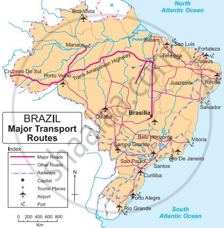 |
- Which means of transport are seen on the map?
- Which means of transport has a denser network?
- Which highway can be seen prominently? Which places does it join?
- What could be the reason of development of railways in the South-East?
- In which part of Brazil do you see a lesser development of transport network ? What could be the reason?
Short Note
Solution
- All the means of transport like roadways, railways, airways, and waterways are seen on the map.
- The roadways have a denser network.
-
The Trans Amazonian Highway can be seen prominently. It connects Cruzeiro do sul, Porto Velho, Manaus and Brasilia.
- South-east Brazil is the richest and the most populated region of the country. Agriculture, mining, and tourism are well developed in this part of Brazil.
-
Amazon in the north and Pantanal in the west have lesser development of transport network. Amazon in the north due to dense forest cover whereas Pantanal is a swampy land.
shaalaa.com
Is there an error in this question or solution?
