Topics
Physical Environment
Locational Setting - India
- Locational Setting - India
Structure of India
- Geological Formation
- Relief and Drainage
- Major Physiographic Divisions and Their Characteristics
Climate: India
- Factors Affecting the Indian Climate
- Role of Various Factors Affecting Indian Climate
- Seasons of India
- Droughts and Floods
Natural Vegetation
- Major Vegetation Types of India
- Factors Affecting Vegetation
- Classification of Vegetation Types
- Importance of Forest to Man
- Forest Conservation Movement
- National Forest Policy (1988)
Population and Human Settlements
Population of India compared to six countries
- Population of India Compared to Six Countries
National and State Level Patterns of Population Distribution
- Definition of Census
- Spatial Distribution of Population in India
Pattern of Population Growth in the Last Three Decades; Implications for Development
- Concept of Terminologies
- Population Growth of India at National Level
- Drawing General Conclusions
Migration Trends Over the Last 25 Years
- Important Terms of Migration
- Types of Migration
- Streams of Migration
Demographic attributes at National level
- Rural Urban Population
- Age and Sex Composition
- Literacy Levels
- Working and Non- Working Population
- Causes and Trends of Demographic Attributes
Rural settlements
- Concept of Rural Settlements
- Distinction Between Rural and Urban Settlements
- Factors Affecting the Rural Settlements
Urban settlements
- Concept of Urban Settlements
- Definition of Urban Area
- Trends of Urbanization
- Factors Influence the Urbanization
Resources of India and Their Utilisation
Need for Environmental Management Vis-à- Vis Development.
- Need for Environmental Management and Development.
Land Resources
- Concept of Land Resources
- Defining the Term Land Resource
Water Resources and Types of Irrigation
- Concept of Water Resources
- Sources of Irrigation:
- Use and Misuse of Water for Irrigation
Agriculture: Types, Development and Problems
- Wet and Dry Agriculture
- Diversification of Indian Agriculture
- Comparative Studies
Fishing in India, Japan and Bangladesh.
- Fishing in India, Japan and Bangladesh.
Sources of Energy
- Minerals and Power Resources
- Conventional Energy Sources
- Non-conventional Energy Sources
Infrastructural Resources
Railways, Roadways, Water Transport (Inland and Coastal), Air Transport, Pipelines - These Modes of Transport Are to Be Studied with Regard to
- Railways Transport
- Roadways Transport
- Water Transport
- Air Transport
- Pipelines
- Concept of Ports
Communication – Importance of Communication in Rural Development and Its Policy. Importance of Infrastructure as Key to the Development of an Industrial Economy.
- Communication
- Modern Means of Communication
Industries
Study of the Location and Distribution of Important Industrial Centres; a General Comparison of Disparities.
- Location and Distribution of Important Industrial Centres
Major and Minor Industrial Regions – Factors Governing Their Growth
- Concept of Major and Minor Industrial Regions
- Major Industrial Regions:
- Minor Industrial Regions:
Location, production and growth of the following industries
- Agro Based Industries
- Mineral Based Industries
Tourism Industry
- Concept of Tourism Industry
Regional Economic Development
- Regional Economic Development
Map Work
- Map List
- Sketch Maps
Definition
- Latitude: The angular distance of a place north or south of the earth's equator, or of the equator of a celestial object, usually expressed in degrees and minutes. Some important latitudes are: Equator (Latitude 0°), Tropic of Cancer (Latitude 23.5°N), Tropic of Capricorn (Latitude 23.5°S), Arctic Circle (Latitude 66.5°N) and Antarctic Circle (Latitude 66.5°S).
- Altitude: The height of an object or point in relation to sea level or ground level.
- Relief: Difference in height from the surrounding terrain.
- Jet stream: Jet streams are relatively narrow bands of strong wind in the upper levels of the atmosphere.
- Wind: The perceptible natural movement of the air, especially in the form of a current of air blowing from a particular direction.
- Tropical cyclone: Tropical cyclone, also called typhoon or hurricane, an intense circular storm that originates over warm tropical oceans and is characterized by low atmospheric pressure, high winds, and heavy rain.
- Western Cyclonic Disturbances: Weather phenomena of the winter months brought in by the westerly flow from the Mediterranean region.
- Coriolis force: An apparent force caused by the earth’s rotation. The Coriolis force is responsible for deflecting winds towards the right in the northern hemisphere and towards the left in the southern hemisphere. This is also known as ‘Ferrel’s Law’.
- El-Nino: A warm ocean current that occasionally appears off the coast of Peru in South America in December.
Notes
Factors affecting the Indian Climate:
Climate refers to a generalised and composite picture of the average weather conditions spread over a long period, for a given large area. The following factors have an impact on India's climate:
1. The Himalayas:
- The Himalayas serve as a climatic barrier between India and the rest of Asia.
- They not only keep the cold Siberian winds out of the Indian region, preventing it from becoming a cold desert, but they also force the moisture-laden South West Monsoon winds to drop rain in India, otherwise India would be a dry region.
2. Varied Relief:
- Relief plays an important role in India's climatic conditions.
- The Western Ghats receive heavy rainfall on the western side because they block the South West Monsoon winds from the Arabian Sea.
- The Deccan Plateau, on the other hand, receives less rainfall due to its location in the rainshadow of the Western Ghats.
- The Aravali Range in Rajasthan runs parallel to the direction of the South West Monsoon winds. As a result, it is powerless to stop the moisture-laden winds. Rajasthan is thus a dry region.
- The southern hills of Assam receive a lot of rain, but the northern hills do not. This is due to the southern hills forcing moisture-laden winds to shed their moisture before continuing northward.
3. The Monsoon Winds:
- The monsoon winds have a nearly universal effect in bringing summer rains to South Asia.
- During the summer, winds from the Arabian Sea and the Bay of Bengal blow quickly into Peninsular India, bringing low-pressure systems from the Arabian Sea and the Bay of Bengal. The moisture carried by these south-westerly winds from the Arabian Sea and Bay of Bengal causes rain to fall across the entire subcontinent, leaving Tibet dry in the 'rainshadow' of the Himalayas.
- The south-west monsoon begins to recede from Punjab and Uttar Pradesh by the end of September, Central India by the end of October, and South India by the end of November. Rain falls in the eastern coastal region as the monsoon retreats.
- During the winter, dry offshore, North-East Monsoon winds blow from a high pressure region to a low pressure region centred at the mouth of the Bay of Bengal. These winds come from Mongolia and northwest China. They are cold and dry as they blow across a vast landmass. These cold, dry winds combine with the Trade Winds to cross the Bay of Bengal. In the winter, they collect moisture from the Bay of Bengal and transport it to Tamil Nadu.
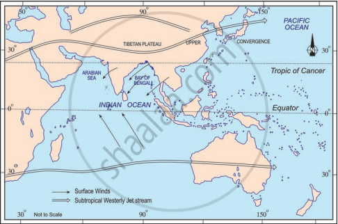
|
Atmospheric Conditions over the Indian Subcontinent in the Month of January |
|
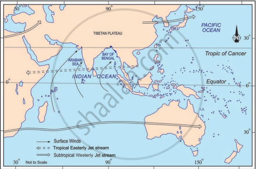
Atmospheric Conditions over the Indian Subcontinent in the Month of June |
4. Latitude:
- The Tropic of Cancer divides the Indian subcontinent into two halves.
- The northern half is temperate, while the southern half is tropical.
- The northern zone's warm temperate or subtropical climate produces a cold winter season and a hot summer season.
- India's southern tropical climatic zone is warmer than the north and lacks a distinct winter season.
- Similarly, the northern zone does not have the mid-day sun almost vertically overhead at any time of year, whereas the southern zone has it at least twice a year.
5. Altitude:
- Because temperature decreases as altitude increases, there is a 1°C decrease for every 166 m increase in height. As a result, the mountains are cooler than the plains.
- Because of the altitude, Ooty has a much lower temperature than Kochi.
6. Influence of the Surrounding Seas:
- India is surrounded by three bodies of water: the Indian Ocean, the Bay of Bengal, and the Arabian Sea, all of which have a significant impact on the climate, particularly in coastal areas.
- These water bodies serve as the primary source of moisture for the summer monsoons, which bring heavy rain to the entire region.
- In fact, these areas have a temperate climate due to their proximity to the sea.
7. Western Disturbances:
- The distribution pattern of pressure in Central and West Asia influences weather conditions during the winter.
- During the winter season, westerlies blow from 20°N to 50°N latitude due to pressure belt shifting, and north India is influenced by winds and cyclones rising from the Mediterranean Sea. These cyclones bring rain to the Northern Plains and snow to India's Jammu and Kashmir.
8. Jet Streams:
- Jet streams are cold fast blowing winds that develop in the upper layers of the atmosphere.
- They have an impact on India's climate.
- During the winter, the westerly jet stream dominates the North Indian Plains, while the easterly jet stream steers the tropical depression over India. These depressions have a significant impact on the pattern of monsoon rainfall distribution in the subcontinent. The most rain falls along the path of these depressions.
9. Distance from the Sea:
- The interiors of India have an extreme or continental climate, whereas coastal areas have an equable or maritime climate.
- The effect of land breeze and sea breeze caused by the differential rate of heating and cooling of land and sea is responsible for coastal climate being moderate.
- The Western Ghats in the Peninsula prevent such benefits from being carried far inwards by the winds. As a result, the sea's moderating influence is limited to coastal areas.
10. El-Nino Effect
- El-Nino is a warm ocean current that occasionally appears off the coast of Peru in South America in December. It raises sea surface temperatures affects the movement of monsoon winds in the Indian Ocean, and causes a weak drought-like situation in the Indian subcontinent.
Text
|
Do you know?
|
Example
Find out the temperature of Ooty (2240m) when it is 35°C in Chennai (6.7m)
Given: Temperature in Chennai having elevation of 6.7 m = 35 degree celcius
Elevation of Ooty = 2240 m
To Find: Temperature of Ooty.
Solution: The temperature of Ooty can be found out by using Normal Lapse Rate (NLR). According to the Normal Lapse Rate, the temperature of the earth atmosphere decreases 6.5 degree celcius with every 1000 m altitude.
Altitude difference between Ooty and Chennai = 2240 - 6.7 = 2233.3 m = 2.2333 Km
Hence, the temperature drop will be 2.233 * 6.5 = 14.51 degree celcius.
Therefore, temperature at Ooty will be = 35 - 14.51 = 20.49 degree celcius.
