Advertisements
Advertisements
प्रश्न
Attaining Sustainable development in the command area requires major thrust upon the measures to achieve ecological sustainability. Highlight the measures proposed to promote sustainable development in the command area of Indira Gandhi Rajasthan Canal.
उत्तर
Seven measures proposed to promote sustainable development in the command area are meant to restore ecological balance.
- The first requirement is the strict implementation of a water management policy. The canal project envisages protective irrigation in Stage-I and extensive irrigation of crops and pasture development in Stage II.
- In general, the cropping pattern shall not include water-intensive crops. It shall be adhered to and people shall be encouraged to grow plantation crops such as citrus fruits.
- The CAD programmes such as the lining of watercourses, land development and levelling and warbands system (equal distribution of canal water in the command area of the outlet) shall be effectively implemented to reduce the conveyance loss of water.
- The areas affected by waterlogging and soil salinity shall be reclaimed.
- The eco-development through afforestation, shelterbelt plantation and pasture development are necessary, particularly in the fragile environment of Stage II.
- The social sustainability in the region can be achieved only if the land allottees having poor economic backgrounds are provided adequate financial and institutional support for the cultivation of land.
- The economic sustainability in the region cannot be attained only through the development of agriculture and animal husbandry. The agricultural and allied activities have to develop along with other sectors of the economy. This shall lead to diversification of the economic base and the establishment of functional linkages between basic villages, agro-service centres and market centres.
APPEARS IN
संबंधित प्रश्न
Mention any three factors that affect inland water transport in India.
What are the advantages of water transport?
Name the seas linked by the Suez canal.
How is milk supplied from farms to factories in New Zealand?
What is the objective of under construction Pan-American highway?
How are rivers modified to enhance their navigability?
Write a note on the Danube waterway.
Why is the North Atlantic sea route significant?
Which canal has shortened the distance between Europe and Asia? Give five points on the canal.
Which canal has shortened the distance between the eastern and western coasts of North America? What is its economic significance?
Which is the most heavily used inland waterways in the world? Why is it important?
Name the inland waterway of Europe that connects Rotterdam and Basel.
Give the significance of the river St. Lawrence as an inland waterway.
Name the seaports on each end of the Suez Canal.
“The Volga is one of the most developed inland water-ways in Russia”. Justify.
Write any four characteristics of this canal.
When was the Suez canal constructed?
Which, seas are joined by the Suez canal?
Which seas are joined by the Panama canal?
Which is the busiest sea route in the world?
Which of the following is NOT a port?
Consider the following statements, and choose the correct option for the same:
- In India compact village of two hundred hours is a rather universal feature, particularly in the northern.
- People live in compact villages for security or defense reasons. In some areas scarcity of water has necessitated compact settlement for maximum utilization of available water.
Which river supplies freshwater to the Suez canal?
Explain the importance of waterways as a mode of transportation.
Mention the important features of 'the Great Lakes - St. Lawrence Seaway'.
Explain the main features of the 'Panama canal'.
Study the given picture and answer the questions that follow:

- Name the waterway give in the picture.
- Name the two sea connected by this waterway.
- Name the ports marked as 'A' & 'B' in this picture.
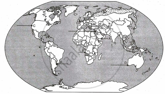
On the given political outline map of the world seven geographical features have been marked as A, B, C, D, E, F and G. Identify any five and names them on the lines marked near them:
- An International Airport in Asia.
- A canal linking Red sea with Mediterranean sea.
- A major seaport in North America.
- A terminal station on the Trans-Australian Railway.
- A major area of nomadic herding in Africa.
- A major area of extensive commercial grain farming.
- International airport of Europe.