Advertisements
Advertisements
प्रश्न
Discuss raster and vector data formats. Give example.
संक्षेप में उत्तर
उत्तर
1. Raster Data Format
Raster data format represents a graphic feature as a pattern of grids of squares.
The Raster file formats are most often used for the following activities:
- For digital representations of aerial photographs, satellite images scanned paper maps, etc.
- When costs need to be kept down.
- When the map does not require analysis of individual map features.
- When backdrop maps are required.
- Advantages
- Simple data structure
- Easy and efficient overlaying
- Compatible with satellite imagery
- High spatial variability is efficiently represented
- Simple for own programming
- Same grid cells for several attributes
- Disadvantages
- Inefficient use of computer storage
- Errors in perimeter and shape
Fig. Effect of Grid Size on data in Raster Format

2. Vector Data Format
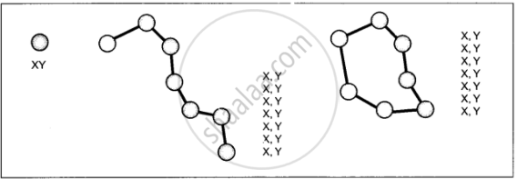
Vector data represents the object as a set of lines drawn between specific points.
The Vector files are most often used for:
- Highly precise applications
- When file sizes are important.
- When individual m; features require analysis.
- When descriptive information must be stored.
- Advantages
- Compact data structure
- Efficient for network analysis
- Efficient projection transformation
- Accurate map output
- Disadvantages
- Complex data structure
- Difficult overlay operations
Fig. The Vector Data Model is based around coordinate pairs

shaalaa.com
Spatial Data Formats
क्या इस प्रश्न या उत्तर में कोई त्रुटि है?
