Advertisements
Advertisements
प्रश्न
How weather maps and charts are useful to us?
दीर्घउत्तर
उत्तर
Utility of weather maps:
- Weather maps help us to predict weather.
- Weather forecasting helps farmers, fishermen, soldiers, navigators and pilots in many ways.
- Disaster management is not possible without weather maps and charts. Weather Charts: The data received from various weather observatories are in plenty and detailed. As such, they cannot be incorporated in one single chart unless the coding designed to give the economy of expression is used. These are called synoptic weather charts and the codes used are called meteorological symbols.
Utility of weather charts:
- Weather charts provide the primary tools for weather forecasting.
- They help in locating and identifying different air masses, pressure systems, fronts and areas of precipitation.
shaalaa.com
Weather Maps and Charts
क्या इस प्रश्न या उत्तर में कोई त्रुटि है?
APPEARS IN
संबंधित प्रश्न
The primary tool for weather forecasting is______.
What is a weather chart?
Discuss how weather maps and charts are prepared.
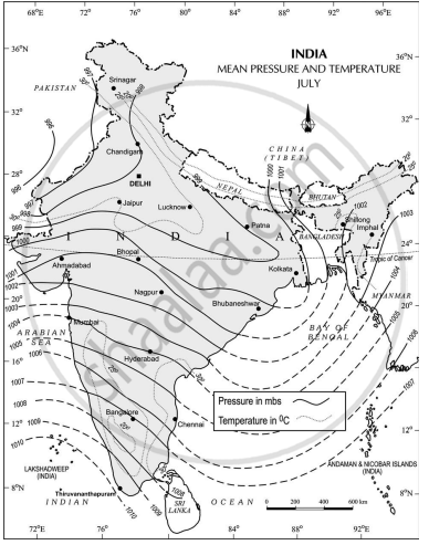
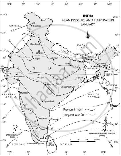
Study the following figures and answer the following questions.
- Which seasons are shown in these maps?
- What is the value of the highest isobar in Figure A and through which part of the country does it pass?
- What are the values of the highest and the lowest isobars in Figure B and where are they located?
- What are the patterns of temperature distribution in both the maps?
- In which parts do you see the highest and the lowest mean temperature in Figure A?
- What relationship do you see between the distribution of temperature and pressure in both the maps?
Figure A

Figure B

