Advertisements
Advertisements
प्रश्न
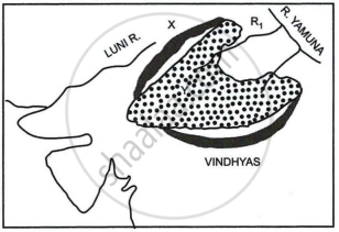
Study the sketch map given below and answer the questions that follow:

- Identify the dotted region marked Y. Mention any three of its characteristic features.
- Name the mountain range marked X, the river marked R1 and the type of rock that constitutes the dotted region.
उत्तर
- The Malwa Plateau is shown on the map as the dotted area.
This region has three key characteristics:- One example of a piedmont plateau is the Malwa plateau. The Deccan Traps, which were formed between 60 and 68 million years ago, are extended by the plateau. The Malwa Plateau is 500 meters above sea level on average.
- It was created by intense volcanic activity that occurred 66 million years ago. The soil is black and fertile.
- The rivers Chambal, Sipra, Kali Sindh, and Parbati drain the gently sloping Malwa plateau to the north.
- On the plateau, the area is covered in savanna-type vegetation, and in the southern portion, on the spurs of the Vindhya and Satpura ranges, it is covered in moist deciduous forests.
- X: Aravalli Range, R1: Chambal and Type of rock in the dotted region: Igneous rocks (primarily basalt)
APPEARS IN
संबंधित प्रश्न
Briefly explain the geological evolution of the Himalayas.
Give reasons for the following
(i) There is a dense network of railways over the North Indian Plains.
(ii) Peninsular Plateau has a high proportion of metalled roads.
(iii) A good transport network promotes industrial development.
Answer the following question:
The figure below represents a topographic section from the Himalayas to the Peninsular region. Identify any two of the features marked A, B, C, and D.
Name any two standard geological eras, along with their duration.
Answer the following question:
Briefly explain the geological evolution of the peninsular plateau.
Name the following :
A historic place in Rajasthan.
Mention any two characteristics features of the Himalayas.
India is referred to as a sub-continent. Justify.
How is the Himalayan River system different from the Peninsular River system?
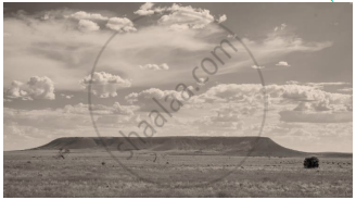
Identify the image given below and explain the formation of this geological division in India.

