Commerce (English Medium)
Science (English Medium)
Arts (English Medium)
Academic Year: 2024-2025
Date: मार्च 2025
Advertisements
General Instructions:
Read the following instructions carefully and follow them:
- This questions paper contains 30 questions. All questions are compulsory.
- Question paper is divided into five sections A, B, C, D and E.
- Section A Questions no. 1 to 17 are Multiple Choice type questions. Each question carries 1 mark.
- Section B Questions no. 18 and 19 are Source-based questions. Each question carries 3 marks.
- Section C Questions no. 20 to 23 are Short Answer type questions. Each question carries 3 marks. Answer to these questions shall be written in 80 to 100 words.
- Section D Questions no. 24 to 28 are Long Answer type questions. Each question carries 5 marks. Answer to these questions shall be written in 120 to 150 words.
- Section E Questions no. 29 and 30 are Map-based questions. Each question carries 5 marks.
- In addition to this, NOTE that a separate question has been provided for Visually Impaired candidates in lieu of questions having visual inputs, map etc. Such questions are to be attempted by Visually Impaired candidates only.
- There is no overall choice given in the question paper. However, an internal choice has been provided in a few questions in all sections other than Section A.
The Human Poverty Index measures the shortfall in human development on the basis of which parameter/s?
The adult literacy rate and the life expectancy at birth.
Access to resources in terms of purchasing power.
The number of small children who are underweight.
The number of children enrolled in the school.
Chapter:
Assertion (A): Often smaller countries have done better than larger ones and relatively poorer nations have been ranked higher than richer neighbours in terms of human development.
Reason (R): Size of the territory and per capita income are not directly related to human development. Countries with higher human development are those where a lot of investment in the social sector has taken place.
Both (A) and (R) are true but (R) is not the correct explanation of (A).
Both (A) and (R) are true and (R) is the correct explanation of (A).
Both (A) and (R) are incorrect.
(A) is correct but (R) is incorrect.
Chapter:
Which of the following statements are correct related to rural marketing centres? Choose the correct option.
- Rural marketing centres cater to nearby settlements.
- Rural marketing centres are quasi-urban trading centres of the most rudimentary type.
- They offer manufactured goods as well as many specialized markets develop, e.g., markets for labour, housing, semi or finished products.
- Personal and professional services are not well developed. These form local collecting and distributing centres.
i, ii, iv
i, iii, iv
ii, iii, iv
i, ii, iii
Chapter:
Arrange the following facts related to the history of international trade in sequence.
- The Silk Route is an early example of long distance trade connecting Rome to China – along the 6,000 km route.
- After the disintegration of the Roman Empire, European commerce grew during twelfth and thirteenth century with the development of ocean going warships trade between Europe and Asia grew and the Americas were discovered.
- Fifteenth century onwards, the European colonialism began and along with trade of exotic commodities, a new form of trade emerged which was called slave trade.
- During the World Wars I and II, countries imposed trade taxes and quantitative restrictions for the first time.
i, ii, iv, iii
iv, ii, iii, i
i, ii, iii, iv
iii, ii, iv, i
Chapter:
The act of opening up economies for trading by bringing down trade barriers like tariffs and allowing goods and services from everywhere to compete with domestic products and services is called ______.
Dumping
Trade liberalization
Balance of trade
Bilateral trade
Chapter:
Arrange the following states in order of their population from highest to lowest.
- Bihar
- Maharashtra
- Uttar Pradesh
- West Bengal
1, 3, 2, 4
4, 3, 2, 1
3, 2, 1, 4
2, 1, 4, 3
Chapter:
There are four distinct phases of population growth identified in India over the last one century. Identify the phase from the given description.
This period is referred to as the period of population explosion in India, which was caused by a rapid fall in the mortality rate but a high fertility rate of population in the country. The average annual growth rate was as high as 2.2 percent. It is in this period that developmental activities were introduced through a centralized planning process and economy started showing up ensuring the improvement of living condition of people at large. Consequently, there was a high natural increase and higher growth rate.
Phase I 1901-1921
Phase II 1921-1951
Phase III 1951-1981
Phase IV post 1981 till present
Chapter:
The objective of protective irrigation is to ______.
protect the crops from adverse effects of soil moisture deficiency.
provide sufficient soil moisture in the cropping season to achieve high productivity.
double water input per unit area of cultivated land so that multiple cropping can be done.
increase the productivity of soil.
Chapter:
Assertion (A): There has been a significant increase in agricultural output and yield of many crops, such as rice and wheat, among the other crops like sugarcane, oilseeds and cotton, due to improvement in technology during the last 50 years.
Reason (R): Expansion of irrigation has played a crucial role in enhancing agricultural output in the country. It provided the basis for the introduction of modern agricultural technology during the last 50 years.
Both (A) and (R) are true but R is not the correct explanation of (A).
Both (A) and (R) are true and (R) is the correct explanation of (A).
Both (A) and (R) are incorrect.
(A) is correct but (R) is incorrect.
Chapter:
Identify the statement that is NOT true with regard to watershed management?
- It refers to efficient management and conservation of surface and groundwater resources.
- Watershed management includes judicious use of all resources – Both natural and human with in a watershed.
- Watershed management aims at bringing about balance between natural resources on the one hand and society on the other.
- The success of watershed development solely depends upon the state government.
Statement I and IV
Only II
Only III
Statement IV
Chapter:
A group of students were conducting research on water pollution levels in Delhi. Which organization will students need to visit to gather information on water quality?
Delhi Pollution Control Committee (DPCC)
Indian Council of Environmental Research (ICER)
National Water Development Agency (NWDA)
Central Pollution Control Board (CPCB)
Chapter:
Which one of the following is incorrectly matched?
| List I (Name of the state) | List II (Coal mining Centre) |
| West Bengal | Raniganj |
| List I (Name of the state) | List II (Coal mining Centre) |
| Tamil Nadu | Neyveli |
| List I (Name of the state) | List II (Coal mining Centre) |
| Maharashtra | Korba |
| List I (Name of the state) | List II (Coal mining Centre) |
| Odisha | Talcher |
Chapter:
Satellite is mode of communication in themselves as well as they regulate the use of other means of communication. Choose the correct satellite system used by India.
- India Remote Sensing Satellite System (IRS)
- Indian Space Research Organization (ISRO)
- Indian Nation Satellite System (INSAT)
- India Regional Navigation Satellite System
Both I and III
Only I
Both II and III
Only IV
Chapter:
Setubharatam Pariyojana launched by the Indian government aims to achieve?
Development of State roads along coastal border areas.
The construction of about 1500 major bridges and 200 rail over bridges and rail under bridges.
Development of border roads.
Construction of more water ways.
Chapter:
Advertisements
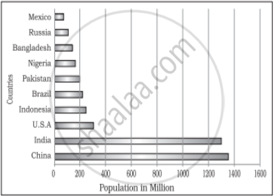
Identify the highest populous country?
Russia
India
Canada
China
Chapter:
Identify the African country that has very high population.
Mexico
Brazil
Pakistan
Nigeria
Chapter:
Which continent has the highest number of the world's most populous countries?
Africa
North America
Asia
South America
Chapter:
Read the passage carefully and answer the questions that follows:
|
Tourism Tourism has become the world’s single largest tertiary activity in total registered jobs (250 million) and total revenue (40 percent of the total GDP). Besides, many local persons, are employed to provide services like accommodation, meals, transport, entertainment and special shops serving the tourists. Tourism fosters the growth of infrastructure industries, retail trading, and craft industries (souvenirs). In some regions, tourism is seasonal because the vacation period is dependent on favourable weather conditions, but many regions attract visitors all the year round. The warmer places around the Mediterranean Coast and the West Coast of India are some of the popular tourist destinations in the world. Others include winter sports regions, found mainly in mountainous areas, and various scenic landscapes and national parks, which are scattered. Historic towns also attract tourists, because of the monument, heritage sites and cultural activities. |
- What constitutes tourism?
- List two renowned global tourist destinations.
- “Tourism has become the largest tertiary activity in the world”. Comment.
Chapter:
Study the following table and answer the questions:
| Level of Human Development | Score in Development Index | Number of Countries |
| Very High | above 0.800 | 66 |
| High | between 0.700 up to 0.799 | 53 |
| Medium | between 0.550 up to 0.699 | 37 |
| Low | below 0.549 | 33 |
- Identify the human development score for the countries classified as having Medium Human Development?
- What can you infer about the well-being of people living in countries with a high level of human development?
- Give reasons for low level of human development in 33 countries.
Chapter:
Explain humanisation of nature with the help of a real-life example.
Chapter:
“The concept of Neo-determinism is compared with traffic lights on the cross road”. Analyze the statement with examples.
Chapter:
Study the map of Suez Canal and answer the following questions:
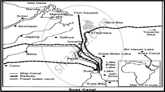
- Name the two seas connected by the Suez Canal.
- Why do we consider this as Europe’s gateway to the Indian Ocean?
- Write one characteristic of the Suez Canal.
Chapter:
Prepare a proposal for a smart city that integrates advanced technology to enhance urban living while prioritising sustainability, cleanliness and affordability.
Chapter:
Enumerate the challenges confronting society regarding the adolescent population. Enlist a few measures to overcome these problems.
Chapter:
How does food gathering as an economic activity differ between primitive and modern societies?
Chapter:
Why is food gathering unlikely to significantly influence the global economy today?
Chapter:
Advertisements
Assess the factors that contributed to the development of large-scale industries all over the world.
Chapter:
Access to transportation and communication facilities are essential for the development of industries.’ Justify the statement with suitable example.
Chapter:
Evaluate the benefits derived from Integrated Tribal development Project implemented in Bharmaur Region.
Chapter:
'Hill Area Development Programmes were initiated for the specified areas keeping in view their topographical, ecological, social and economic conditions'. Justify the statement.
Chapter:
The composition of commodities in India’s international trade has been undergoing a change over the years. Substantiate the statement with suitable arguments.
Chapter:
‘Air transport plays an important role in the international trade’. Justify the statement with suitable arguments.
Chapter:
‘Environmental pollution by solid wastes has now got significance due to enormous growth in the quantity of waste’.
Chapter:
Give reasons for the unsustainable increase in solid waste.
Chapter:
On the given political map of the World, seven geographical features have been marked as A, B, C, D, E, F and G. Identify any five with the help of the following information and write their correct names on the lines drawn near each feature.
- A major seaport.
- An international airport.
- An important Seaway.
- An area of subsistence gathering in South America.
- An important seaport of Asia.
- An area of Nomadic Herding.
- Region of extensive commercial grain agriculture.

Chapter: [0.09] International Trade
Locate and label the following geographical features on the Political Outline map of India with appropriate symbols:
- An important coal mine in Orisha.
- An important seaport in Karnataka.
- Jharia – Coal mines.
- An oil refinery in Uttar Pradesh.
- The state with lowest population density.
- The state leading in the production of Tea.
- An international airport in Punjab.
Chapter:
Other Solutions
Submit Question Paper
Help us maintain new question papers on Shaalaa.com, so we can continue to help studentsonly jpg, png and pdf files
CBSE previous year question papers Class 12 Geography with solutions 2024 - 2025
Previous year Question paper for CBSE Class 12 Geography-2025 is solved by experts. Solved question papers gives you the chance to check yourself after your mock test.
By referring the question paper Solutions for Geography, you can scale your preparation level and work on your weak areas. It will also help the candidates in developing the time-management skills. Practice makes perfect, and there is no better way to practice than to attempt previous year question paper solutions of CBSE Class 12.
How CBSE Class 12 Question Paper solutions Help Students ?
• Question paper solutions for Geography will helps students to prepare for exam.
• Question paper with answer will boost students confidence in exam time and also give you an idea About the important questions and topics to be prepared for the board exam.
• For finding solution of question papers no need to refer so multiple sources like textbook or guides.
