SSC (English Medium)
Academic Year: 2019-2020
Date: मार्च 2020
Advertisements
1) All the activities/questions are compulsory.
2) Figures to the right indicate full marks.
3) Use of stencil is allowed for drawing map
4) Draw neat diagrams and sketches wherever necessary
5) Answers should be written in Black and Blue ink only.
6) Use of pencil/colour pencil is allowed for diagrams, sketches and map work.
7) Answers written in pencils will not be considered.
India’s southernmost point is known as ______.
Lakshadweep
Kanyakumari
Indira point
Port Blair
Chapter: [0.02] Location and Extent
Select the correct option and rewrite the sentence:
------------ is seen as one of the world’s major markets and contributor to economic growth of the world.
a) India
b) Brazil
c) Sri Lanka
d) Japan
Chapter: [0.08] Economy and Occupations
Fill in the blank by choosing the correct alternative :
The main motive producer is to maximise profit in ______________ economy.
Socialist
capitalist
mixed
Chapter: [19.01] Introduction of an Economy
The rate of urbanization in Brazil has reduced after the ---------------- decade
a) 1960
b) 1970
c) 1990
d) 2000
Chapter: [0.07] Human Settlements
Match the column.
| A group | B group |
| 1) The southernmost point of India | 1) Gangotri |
| 2) The highlands in eastern Brazil | 2) Andes mountains |
| 3) The origin of Ganga | 3) Guyana Highlands |
| 4) the origin of Amazon | 4) Indira Point |
| 5) Yamunotri | |
| 6) The Great Escarpment |
Chapter: [0.02] Location and Extent
Differentiate between the physiography of Brazil and India.
Chapter: [0.03] Physiography and Drainage
Advertisements
Differentiate between the forest types of Brazil and India.
Chapter: [0.05] Natural Vegetation and Wildlife
Differentiate between.
Water transport in the Amazon and the Ganga river.
Chapter: [0.09] Tourism, Transport and Communication
Mark the following in the outline map of Brazil supplied to you, write the names and give index

(1) Marajo Island
(2) Pico-De-Neblina
(3) Pantanal Wetland
(4) Drought Quadrilateral
(5) Caatinga
(6) Golden Lion-Tamarin
Chapter: [0.08] Economy and Occupations
Look at the digital elevated model (DEM) of India and name the major physiographic divisions.

Chapter: [0.03] Physiography and Drainage
Give geographical reason.
Population is an important resource.
Chapter: [0.06] Population
Give geographical reason.
Availability of water is a major factor affecting settlements.
Chapter: [0.07] Human Settlements
Advertisements
Give geographical reason.
Eco-tourism is being developed more in Brazil.
Chapter: [0.09] Tourism, Transport and Communication
Give a geographical reason.
The waterways are not developed in Brazil.
Chapter: [0.09] Tourism, Transport and Communication
With the help of given statistical data prepare a simple bar graph and answer the following questions:
India – Trend of Urbanisation (1961-2011)
| Year | Percentage of Urban Population |
| 1961 | 18.0 |
| 1971 | 18.2 |
| 1981 | 23.3 |
| 1991 | 25.7 |
| 2001 | 27.8 |
| 2011 | 31.2 |
(1) What is the interval of the data?
(2) Which decade shows slow rate of urbanisation?
(3) Which decade shows high rate of urbanisation?
Chapter: [0.06] Population
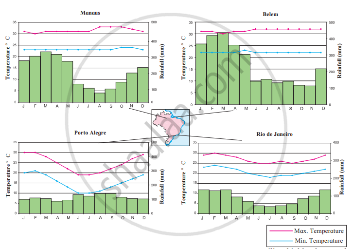
Study the graphs given in Fig and answer the following questions.
- In which month is the highest temperature found in all four cities?
- In which month does it rain the most in the given cities?
- When does Brazil have its rainy season?
- Which city has the maximum range of temperature? How much is it?
- What type of climate will be found in Rio De Janerio?

Chapter: [0.04] Climate
Answer the following in detail.
Explain with examples how field visits increase geographical knowledge.
Chapter: [0.01] Field Visit
What problems did Brazil and India face after independence?
Chapter: [0.02] Location and Extent
What problems did Brazil and India face after independence?
Chapter: [0.02] Location and Extent
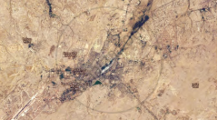
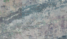
Tell whether settlements shown in images (a) and (b) are urban or rural.
|
(a) |
(b) |
Chapter: [0.07] Human Settlements
Other Solutions
Submit Question Paper
Help us maintain new question papers on Shaalaa.com, so we can continue to help studentsonly jpg, png and pdf files
Maharashtra State Board previous year question papers 10th Standard Board Exam Geography with solutions 2019 - 2020
Previous year Question paper for Maharashtra State Board 10th Standard Board Exam -2020 is solved by experts. Solved question papers gives you the chance to check yourself after your mock test.
By referring the question paper Solutions for Geography, you can scale your preparation level and work on your weak areas. It will also help the candidates in developing the time-management skills. Practice makes perfect, and there is no better way to practice than to attempt previous year question paper solutions of Maharashtra State Board 10th Standard Board Exam.
How Maharashtra State Board 10th Standard Board Exam Question Paper solutions Help Students ?
• Question paper solutions for Geography will helps students to prepare for exam.
• Question paper with answer will boost students confidence in exam time and also give you an idea About the important questions and topics to be prepared for the board exam.
• For finding solution of question papers no need to refer so multiple sources like textbook or guides.


