Advertisements
Chapters
![NCERT solutions for Practical Work in Geography [English] chapter 5 - Topographical Maps NCERT solutions for Practical Work in Geography [English] chapter 5 - Topographical Maps - Shaalaa.com](/images/practical-work-in-geography-english_6:926c1c575b374fb4a77ce82f6642f634.jpg)
Advertisements
Solutions for Chapter 5: Topographical Maps
Below listed, you can find solutions for Chapter 5 of CBSE NCERT for Practical Work in Geography [English].
NCERT solutions for Practical Work in Geography [English] 5 Topographical Maps Exercise [Pages 64 - 65]
Answer the following questions in about 30 words.
What are topographical maps?
Name the organization which prepares the topographical maps of India.
Which are the commonly used scales for mapping our country used by the Survey of India?
What are contours?
What does the spacing of contours indicate?
What are conventional signs?
Write a short note on Contours.
Write short note on ‘Marginal Information’ in Topographical sheets.
Write a short note on the Survey of India.
Explain what is meant by ‘map interpretation’.
What procedure is followed for map interpretation?
If you are interpreting the cultural features from a topographical sheet, what information would you like to seek and how would you derive this information? Discuss with the help of suitable examples.
Draw the conventional signs and symbols for the following features-
- International Boundary
- Bench Mark
- Villages
- Metalled Road
- Footpath with bridges
- Places of Worship
- Railway line
NCERT solutions for Practical Work in Geography [English] 5 Topographical Maps Exercise A [Page 65]
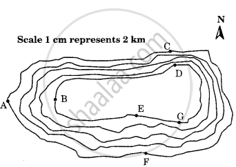
Study the contour pattern and answer the following questions.
- Name the geographical feature formed by contours.
- Find out the contour interval in the map.
- Find out the map distance between E and F and convert it into the ground distance.
- Name the type of slope between A and B; C and D and E and F.
- Find out the direction of E, D, and F from G.

NCERT solutions for Practical Work in Geography [English] 5 Topographical Maps Exercise B [Page 65]
Study the extract from the topographical sheet No. 63K/12, as shown in the figure below and answer the following questions-
- Convert 1:50,000 into a statement of scale.
- Name the major settlements of the area.
- What is the direction of flow of the river Ganga?
- At which one of the banks of river Ganga, Bhatauli is located ?
- What is the pattern of rural settlements along the right bank of river Ganga?
- Name the villages/settlements where Post Office is located ?
- What does the yellow colour in the area refer to?
- What means of transportation is used to cross the river by the people of Bhatauli village?

R. F. 1: 50,000
Part of the Topographical Sheet No 63K/12
NCERT solutions for Practical Work in Geography [English] 5 Topographical Maps Exercise C [Page 67]
Study the extract for topographical sheet 63K/12 shown in the figure below and answer the following questions.
- Give the height of the highest point on the map.
- River Jamtihwa Nadi is flowing through which quarter of the map?
- Which is the major settlement located in the east of the Kuardari Nala?
- What type of settlement does the area have?
- Name the geographical feature represented by white patches in the middle of Sipu Nadi.
- Name the two types of vegetation shown on part of the topographical sheet.
- What is the direction of the flow of the Kuardari?
- In which part of the sheet area is Lower Khajuri Dam located?
 R. F. 1: 50,000
Part of the Topographical Sheet No 63K/12
Solutions for 5: Topographical Maps
![NCERT solutions for Practical Work in Geography [English] chapter 5 - Topographical Maps NCERT solutions for Practical Work in Geography [English] chapter 5 - Topographical Maps - Shaalaa.com](/images/practical-work-in-geography-english_6:926c1c575b374fb4a77ce82f6642f634.jpg)
NCERT solutions for Practical Work in Geography [English] chapter 5 - Topographical Maps
Shaalaa.com has the CBSE Mathematics Practical Work in Geography [English] CBSE solutions in a manner that help students grasp basic concepts better and faster. The detailed, step-by-step solutions will help you understand the concepts better and clarify any confusion. NCERT solutions for Mathematics Practical Work in Geography [English] CBSE 5 (Topographical Maps) include all questions with answers and detailed explanations. This will clear students' doubts about questions and improve their application skills while preparing for board exams.
Further, we at Shaalaa.com provide such solutions so students can prepare for written exams. NCERT textbook solutions can be a core help for self-study and provide excellent self-help guidance for students.
Concepts covered in Practical Work in Geography [English] chapter 5 Topographical Maps are Introduction to Topographical Maps, Methods of Relief Representation, Contour, Types of Slope, Types of Landforms, Valley, Identification of Cultural Features from Topographical Sheets, Topographic or Ordnance Survey Maps, Map Interpretation Procedure.
Using NCERT Practical Work in Geography [English] solutions Topographical Maps exercise by students is an easy way to prepare for the exams, as they involve solutions arranged chapter-wise and also page-wise. The questions involved in NCERT Solutions are essential questions that can be asked in the final exam. Maximum CBSE Practical Work in Geography [English] students prefer NCERT Textbook Solutions to score more in exams.
Get the free view of Chapter 5, Topographical Maps Practical Work in Geography [English] additional questions for Mathematics Practical Work in Geography [English] CBSE, and you can use Shaalaa.com to keep it handy for your exam preparation.
