Advertisements
Advertisements
प्रश्न
Match the column.
| A group | B group |
| 1) The southernmost point of India | 1) Gangotri |
| 2) The highlands in eastern Brazil | 2) Andes mountains |
| 3) The origin of Ganga | 3) Guyana Highlands |
| 4) the origin of Amazon | 4) Indira Point |
| 5) Yamunotri | |
| 6) The Great Escarpment |
उत्तर
| A group | B group |
| 1) The southernmost point of India | 1) Indira Point |
| 2) The highlands in eastern Brazil | 2) The Great Escarpment |
| 3) The origin of Ganga | 3) Gangotri |
| 4) the origin of Amazon | 4) Andes mountains |
संबंधित प्रश्न
Read the following graph and answer the questions.
Temperature and Rainfall in Brazil and India

i) What is the minimum and maximum temperature of India?
ii) What difference do you find in the rainy period in Brazil and India?
iii) In which month does Brazil get less rainfall?
iv) In which month does India get higher rainfall?
v) In which month does India get lesser rainfall?
vi) In which month does Brazil have a higher temperature?
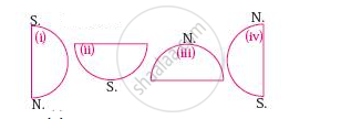
Considering hemisphere, which shape correctly represents the hemisphere in which India lies?

Describe the location of India.
Fill in the blank:
______ is referred to as the National Capital Territory of India.
What is the distance between the east and west extremity of India in Kilometres?
India is situated into southern part of ______.
India is the ______ largest country in Asia.
Identify the correct co-relation and complete the chain.
| A | B | C | |
| 1. | India | Dance type | Capital |
| 2. | Samba | Popular game | Tropic of cancer |
| 3. | Cricket | Passes from centre of India | Brazil |
| 4. | Position of latitude | New Delhi | India |
Identify the following with the help of map reading.
The northernmost latitude in degrees.
Find out the longitudinal and latitudinal extent of your state.
