Advertisements
Advertisements
प्रश्न
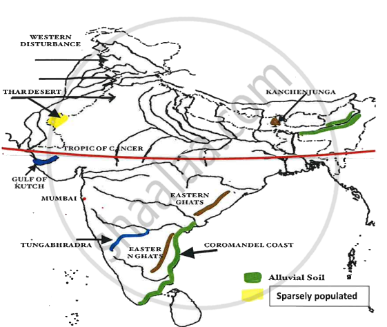
On the outline map of India provided:
- Shade and label an area of alluvial soil in the north-east.
- Mark using a dot and name the commercial capital of India.
- Mark and name the highest peak of the Himalayas in India.
- Shade and label Gulf of Kutch.
- Mark with arrows and name the wind bringing rainfall to Punjab in the winter.
- Shade and label a sparsely populated area.
- Mark and label Eastern Ghats.
- Mark and name a tributary of an important peninsular river.
- Mark and label the most important latitude passing through the country.
- Mark and label Coromandel coast.
उत्तर
APPEARS IN
संबंधित प्रश्न
What is the value of the contour line in square 0226? What is the contour interval in the map?
What is the geographical name that you would give to the general pattern of settlement in the region shown on the map?
By what name is the parallel of latitude 23° 33′ known? Name the zones or belts into which it divides India almost equally.
Why is South Asia referred as Indian Sub-continent?
On the outline map of India provided:
(a) Draw, name and number the Standard Meridian.
(b) Label the river Yamuna.
(c) Shade and name the Gulf of Khambhat.
(d) Mark and name the Nathu-La Pass.
(e) Mark and name the Karakoram Range.
(f) Shade and name a sparsely populated State in Northeast India.
(g) Shade a region with laterite soil in Eastern India.
(h) Mark with a dot and name Vishakhapatnam.
(i) Mark and name the winds that bring rain to West Bengal in summer.
(j) Print S on the iron mines in Singhbhum.
(a) Mark and name Chennai
On the outline map of India provided:
(a) Mark and name Chennai
(b) Label the river Godavari
(c) Shade and label the Chhota Nagpur Plateau
(d) Shade and name the Gulf of Kachchh
(e) Mark and name the Indo-Gangetic Plains
(f) Shade and label an area with Red Soil
(g) Mark and name the winds which bring rain to Mumbai in July and August
(h) Mark and name the Satpura Range
(i) Mark and name the Jharia Coal Field
(j) Shade and label the Northern Circar coastal region
On the outline map of the Indian sub-continent provided to you at the end of this question paper:
(i) Mark with a bold line and label:
(a) The Karakoram Range.
(b) The Eastern Ghats.
(c) The Nilgiris
(ii) Shade and name one region for the : Black soil.
(iii) Mark and label:
(a) The Khyber Pass
(b) The capital city of Assam.
(c) River Godavari.
(iv) (a) Identify, shade and name:
(1) A region of sparse population (less than 50 pp sq.) in North-Eastern India.
(2) A region of ‘Equatorial Forests’.
(b) Mark with one long arrow, the direction of the Summer Monsoon over the Bay of Bengal.
On the map of India,
(a) Label the Konkan Coast, Malabar Coast and the Coromandel Coast in their proper places.
(b) Shade and name the Rann of Kutch.
(c) Mark and name the Ajanta Range.
(d) Mark and name the Khasi-Jaintia Hills.
(e) Mark and name the Patkoi Hills.
(f) Mark and name the Naga Hills.
(g) Mark and name the Cardamom Hills.
(h) Mark and name the Annamalai Hills. Name its highest peak, Anaimudi.
On the map of India,
(a) Mark and name the Shiwalik Range.
(b) Mark and name, the Western Ghats with two gaps, Bhor Ghat and Palghat Gap.
(c) Mark and name the peak on the Karakoram Mts, (Mt. Godwin Austien or Mt. K2).
(d) Mark and name, the highest peak on the Himalayas, (Mt Everest).
(e) Mark and name Mt. Kanchenjunga.
(f) Mark and name the Maikal Range.
(g) Shade and name the Indo-Gangetic Plain.
Name the physical divisions into which India can be divided.
