Advertisements
Advertisements
प्रश्न
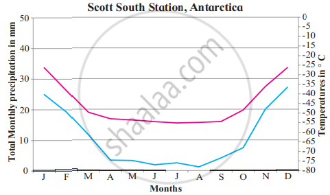
Read the graphs figure a and b and answer the following questions. Locate the places on the map:
- Which are the warmest and the coolest months?
- Name the months of highest and lowest rainfall.
- In what way do you find similarities in this climate with other climate types of high latitudes?
- What factors influence this type of climate?
टीपा लिहा
उत्तर
- The warmest month is July and the coolest month is February in Eismitte. While in Scott South Station warmest months are December and January and the coolest month is August.
- The month with the highest rainfall in Eismitte is December and the lowest rainfall is in May. While in Scott South Station the highest rainfall is in the month of February, while the lowest rainfall is observed in July and August.
- Precipitation is very low in high latitude regions and mostly it is in the form of snowfall. Temperature is below freezing point (0°C) in all the high latitude regions. This is because the sun's rays are oblique and hence temperature is low. These regions are mostly under permanent snow cover.
- Little or no insolation during most of the months in a year, oblique sunrays are the factors responsible for this type of climate.
shaalaa.com
High Latitudinal Regions - Ice Sheet
या प्रश्नात किंवा उत्तरात काही त्रुटी आहे का?


