Advertisements
Advertisements
प्रश्न
The area is measured by grid square method?
उत्तर
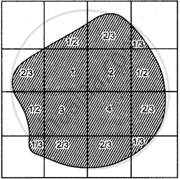
To find the area by the grid square method: The grid square on toposheet measures 2 cm × 2 cm., or 1 km., × 1 km., since 2 cm., is equal to 1 km. Therefore, the area of each square is 1 sq. km. To find particular area on a topographical map:

No .of. complete squares : 4 = 4.0 sq.km
No.of 1/2 squares : 2 = 1.0 sq. km
No.of 2/3 squares : 5 = 3.3 sq.km
No.of 1/3 squares : 4 = 1.3 sq .km
__9.6 sq.km. ___
Note the number of complete grid square within the area and the number of squares lying within the area are not complete.
(i) Square covered half are taken as 1 /2 squares.
(ii) Square covered more than half are taken as 2/3 squares.
(iii) Square covered less than half are taken as 1/3 squares.
Add all the squares thus, the area which has to be found out is calculated.
APPEARS IN
संबंधित प्रश्न
Give the four figure grid reference of the temple in the settlement of Jolpur.
What is the compass direction of Dantrai from Jolpur?
Mention one man-made feature in the map, which also provides evidence that the rainfall is seasonal.
Name two natural features in 0325.
Name the types of drainage pattern found in grid square 9374.
Give the meanings of the important terms used in toposheets.
Give a summary of dimension and scale of topographical maps.
Study the extract of the Survey of India Map sheet No. 45D/10 and answer the following questions:
(a) Give the six figure grid reference of:
(i) The temple in village Dhavli
(ii) ∆ 480
(b) What do the following indicate?
(i) 6r in grid square 1903
(ii) The word Brackish in grid square 1403.
(c)
(i) In grid square 1909, several contours merge at one point. What does this represent?
(ii) State the significance of the red dotted lines in the map extract.
(d) Name the type of rainfall experienced in the region shown in the map extract. Give a reason to support your answer.
(e) How does the drainage pattern in grid square 1606 differ from the drainage pattern in grid square 1708?
(f)
(i) What is the pattern of settlement in grid square 1904?
(ii) Name the settlement that has a post office.
(g) Name two landforms represented by the pattern of contours in grid square 1608.
(h) Calculate the ground distance in kilometres along the metalled road between the causeway in 1502 and the distance stone marked ’14’ in grid square 1203.
(i) State two reasons for the absence of human habitation in the north eastern region of the map extract.
(j)
(i) Mention the difference in height between the highest spot height in the map extract and the contour height in grid square 1006.
(ii) What is the compass direction of Patlawa ka Goliya (590.) from Kacholi Dunga (443.)?
Answer the following questions on the Survey Sheet Number 45 D/7.
(a) Give six figure grid references of the following:
(i) ∆ 364 (ii) The temple at Rampura
(b) Mention any two features seen in the map extract which show that the region has seasonal rainfall
(c) Calculate the distance in kilometres along the cart-track linking Juvol (923826) and Amiwada (944817).
(d) Which is the chief form of irrigation shown in the map extract? Give an evidence to justify your answer.
(e) Give one reason to explain why the streams in grid square 9478 do not join a river. Identify another grid square in the map extract that has similar streams.
(f) What do the following represent:
(i) Black broken lines in 9575 (ii) Black curved lines in 9879.
(g) Identity two landforms shown by the contours in grid square 9876.
(h) (i) What is the general direction of the Balram Nadi?
(ii) Which bank of the main river does the Balram Nadi join?
(i) What is the main occupation of the people living in the area shown in the map extract? Give one reason to support your answer.
(j) What is meant by scale of a map? What is the scale of the map extract provided to you?
Study the extract from the topographical sheet No. 63K/12, as shown in the figure below and answer the following questions-
- Convert 1:50,000 into a statement of scale.
- Name the major settlements of the area.
- What is the direction of flow of the river Ganga?
- At which one of the banks of river Ganga, Bhatauli is located ?
- What is the pattern of rural settlements along the right bank of river Ganga?
- Name the villages/settlements where Post Office is located ?
- What does the yellow colour in the area refer to?
- What means of transportation is used to cross the river by the people of Bhatauli village?

R. F. 1: 50,000
Part of the Topographical Sheet No 63K/12
