Advertisements
Advertisements
Question
Give geographical reason.
Waterways are developed in Brazil.
Solution
- Waterways have been developed on a commercial basis in the Amazon River.
- Boats ply from Equitos in Peru to the mouth of Amazon River. This river has the longest navigational stretch of approximately 3700 km. The port of Manaus has been developed at the confluence of Negro river and Amazon River.
- In addition to this, the Parana River of the south is also suitable for water transport. Coastal shipping is also carried out in the coastal areas.
Thus, we can infer that the waterways are developed in Brazil.
RELATED QUESTIONS
Answer in detail:
Write a note on the water transport in Brazil.
State whether right or wrong with reason.
The indicator of development in a country is the development of transport in that country.
What are the difficulties in the development of the railway system in Brazil's internal areas?
Write notes on
Correlation between physiographic and internal waterways
Distinguish Between
Transportation in India and Brazil
In which parts of Brazil less transportation routes are found?
What is the condition of waterways as a mode of transport in India and Brazil?
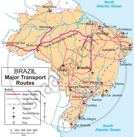
Study the transport map of Brazil in Fig and answer the following questions:
 |
- Which means of transport are seen on the map?
- Which means of transport has a denser network?
- Which highway can be seen prominently? Which places does it join?
- What could be the reason of development of railways in the South-East?
- In which part of Brazil do you see a lesser development of transport network ? What could be the reason?
Match the column:
| Column 'A' | Column 'B' | ||
| (1) | Trans-Amazonian Highway | (a) | Teak |
| (2) | Thorny and bush-type vegetation | (b) | Football |
| (3) | Plain region | (c) | Major Highways |
| (4) | Popular game of Brazil | (d) | Khejadi |
| (e) | Punjab | ||
| (f) | Cricket |
The most common method of transportation in Brazil is ______.
