Advertisements
Advertisements
Question
How to find four-figure and six-figure grid reference?
Solution
Four-figure grid reference: Square grid or four-figure grid reference e.g., the four figure grid reference of A in the figure is 6218. It means that A lies between Eastings 62 to 63 and Northings 18 to 19.
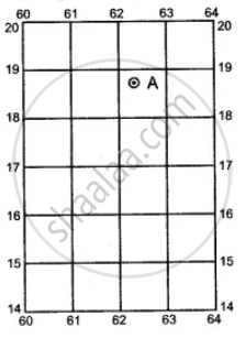
Six-figure grid reference: The six figure grid reference gives the exact location of a feature. For example, the six figure grid reference of A would be 623188. The first three digits gives the Eastings and the next three digits, the Northings. To get the third digit in the Eastings one has to mentally divide the space between 62 to 63 into 10 equal parts.
Thus, the third digits comes to 3. Similarly to get the sixth digit, mentally divide the space between 18 to 19 into 10 equal parts. Thus, the sixth digit comes to 8. The six-figure grid reference of A is 623188.
The grid squares on the toposheets are generally of 1 sq km..
Sometimes there are squares in which are written QC and QD. These denote two lettered number of 100 square km.
APPEARS IN
RELATED QUESTIONS
Mention the methods by which directions are located.
How the compass direction of an object, feature or place given from the given point?
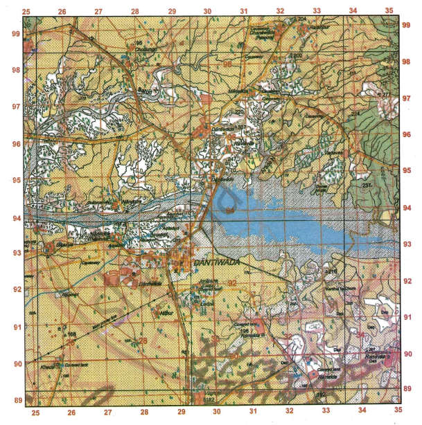
Study the extract of the Survey of India Map sheet No. G43S7 and answer the following question:
Give the four-figure grid reference for Δ224.
Study the extract of the Survey of India Map sheet No. G43S7 and answer the following questions:
-
- Give the six-figure grid reference for spot height .522.
- What is the pattern of settlement in the grid square 3591?
-
- Mention two man-made features seen in the grid square 3794.
- Mention two means of transport used by the people of Nani Bhatamal in the grid square 3691.
-
- Identify the landform marked by the contours in the grid square 3896.
- What is the pattern of drainage seen in the grid square 3697?
-
- What is the reason for the presence of causeway in the grid square 3695?
- What is the compass direction of Khara (4097) from Karja (3994)?
-
Calculate the area in kilometre square of the region to the south of 94 Northing.
Give the four-figure grid reference of the following from the given map extract:

- Two settlements having a Post office.
- Two settlements having a dispensary.
- The Siphon.
- The confluence of the main river and Dior Nadi.
- The area of Brackish water.
- The Annual Fair grounds west of Malgaon.
Give the six-figure grid reference of the following from the given map extract:
- Police Station.
- 4r near the Rocky knob.
- Post office at Malgaon.
- The surveyed tree at Posintra.
- Dispensary north of Posintra.
- Hospital near Pamera.
