Advertisements
Advertisements
Question
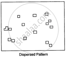
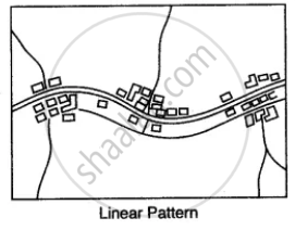
Name the various types of settlement patterns found on toposheet.
Solution

APPEARS IN
RELATED QUESTIONS
What does the blue coloured circle in the grid square 0619 represent?
What is the difference between the pattern of settlements in 0725 and the settlement of Idarla?
Why do you find limited cultivation in the map extract? Give two reasons for your answer
Calculate the distance in kilometres along the cart track between Chitrasani (999747) and Pirojpura (978753).
What do you understand by the term Grid?
What are ‘Eastings’ and ‘Northings’?
Give a summary of dimension and scale of topographical maps.
Study the extract of the Survey of India Map sheet No. 45D/10 and answer the following questions:
(a) What is the compass direction of Sunset Point from the settlement of Anadra?
(b) What is the pattern of drainage in grid square 2315?
(c) Mention any two features seen in the map extract which indicate that the region has seasonal rainfall.
(d) Calculate the distance, in kilometers along the metalled road from the causeway in grid square 1715 to the distance stone marked 20 in grid square 1818.
(e) What advantage does a Representative Fraction have over a verbal scale?
(f) Give the six figure grid reference of:
(i) Anjini Devi ka Mandir
(ii) D 1327.
(g) Name the three different kinds of roads in grid square 2411 and the one in grid square 2515.
(h) Mention two occupations of the people living in the northern part of the region in the map extract. Give reasons to support your answer.
(i) What is the difference between the slope in grid square 2115 and the one in 1811. Give a reason for your answer.
(j) What is the purpose of:
(i) the fireline in grid square 2316.
(ii) the pipeline in grid square 2209?
(k) What do the following represent?
(i) The red square in grid square 2514.
(ii) 4r in grid square 1612,
(l) Abu is a popular holiday resort. Mention any three features seen in the map extract which attract holiday makers to Abu.
Study the extract of the Survey of India Map Sheet No. 45 D/7 (A and B) and answer the following questions.
(a) Give the six figure grid reference of
(i) ∆ 277 (→) (ii) Lime kiln near Rampura (→) (iii) Stony waste (→).
(b) (i) What does the blue line in the Sipu river indicate?
(ii) In which village do you see the nodal function 7 What do you mean by this?
(c) (i) What does the black lines along the streams in the grid square 9199 indicate?
(ii) How are these features formed?
(iii) What type of region is shown in grid square 8696?
(d) Give the six-figure grid reference of the following:
(i) Lime Kiln near village Panswala.
(ii) Well with water near village Gonodara.
(iii) Dry tank near village Mohudi Moti.
(e) (i) What is the direction of the flow of Sipu river?
(ii) State why does it flow in this particular direction?
(f) Mention three natural features in the grid square 8998.
(g)
(i) What is the meaning of the term open scrub printed on the map.
(ii) How do you get an idea of the general nature of the slope in this area?
Write short note on ‘Marginal Information’ in Topographical sheets.
