Advertisements
Advertisements
प्रश्न
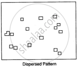
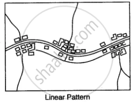
Name the various types of settlement patterns found on toposheet.
उत्तर

APPEARS IN
संबंधित प्रश्न
Name the following: An offshore oil field in the Gulf of Cambay.
How does the feature, indicated by the black curves in 0721, show that rainfall in this region is seasonal?
What type of rainfall is experienced in the region shown in the map extract? Justify your answer giving one reason.
Convert the following scales into R.F.
Calculate the average gradient along the two stations A and B, if the horizontal distance between them is 1,200 metres and the vertical difference in height is 240 metres.
What are ‘Eastings’ and ‘Northings’?
The area is measured by grid square method?
What is Concave Slope and Convex Slope? Explain?
Study the extract of the Survey of India Map sheet No. 45D/10 and answer the following questions:
(a) Give the six figure grid reference of:
(i) The temple in village Dhavli
(ii) ∆ 480
(b) What do the following indicate?
(i) 6r in grid square 1903
(ii) The word Brackish in grid square 1403.
(c)
(i) In grid square 1909, several contours merge at one point. What does this represent?
(ii) State the significance of the red dotted lines in the map extract.
(d) Name the type of rainfall experienced in the region shown in the map extract. Give a reason to support your answer.
(e) How does the drainage pattern in grid square 1606 differ from the drainage pattern in grid square 1708?
(f)
(i) What is the pattern of settlement in grid square 1904?
(ii) Name the settlement that has a post office.
(g) Name two landforms represented by the pattern of contours in grid square 1608.
(h) Calculate the ground distance in kilometres along the metalled road between the causeway in 1502 and the distance stone marked ’14’ in grid square 1203.
(i) State two reasons for the absence of human habitation in the north eastern region of the map extract.
(j)
(i) Mention the difference in height between the highest spot height in the map extract and the contour height in grid square 1006.
(ii) What is the compass direction of Patlawa ka Goliya (590.) from Kacholi Dunga (443.)?
Study the extract of the Survey of India Map sheet No. 45D/10 and answer the following questions:
(a)
Give the six figure grid reference of:
(i) Triangulated height 307.
(ii) The spot height 196.
(b)
Give the four figure grid reference of each of the following:
(i) The confluence of the Sipu River and the Mahadeviyo Nala.
(ii) Sheet rock.
(c) Measure the shortest distance in kilometres between the temple in, grid square 8192, and the perennial lined well at Bhakodar 8188.
(d)
What do the following represent?
(i) Black curved lines in 7788.
(ii) The blue line in the bed of the Sipu River.
(e)
(i) What is the general pattern of settlements in the region shown on the map?
(ii) Give a reason for your answer.
(f) Which is the chief form of irrigation shown in the map extract? Why is it necessary?
(g)
(i) What is the main form of transport in this region?
(ii) Give the map evidence for your answer.
(h)
(i) What is the compass direction of Dantiwada, 8582, fromBhadli Kotha, 7886?
(ii) What is the general direction of flow of the Arado. N?
(i)
(i) Name the type of drainage pattern found in grid square 8584.
(ii) What do you mean by 25r in grid square 8286?
(j)
(i) What is meant by ‘R.F.’?
(ii) What is the R.F. shown on this map extract?
