Advertisements
Advertisements
Question
If a length of 100 m is represented on a map by 1 cm, then the actual distance corresponding to 2 cm is 200 m.
Options
True
False
Solution
This statement is True.
Explanation:
When a length 100 m is respresented on a map by 1 cm.
Then, actual distance corresponding to 2 cm = 2 × 100 = 200 m
APPEARS IN
RELATED QUESTIONS
Look at the given map of a city.

Answer the following.
(a) Colour the map as follows: Blue − water plant, red − fire station, orange − library, yellow − schools, green − park, pink − college, purple − hospital, brown − cemetery.
(b) Mark a green ‘X’ at the intersection of Road ‘C’ and Nehru Road, Green ‘Y’ at the intersection of Gandhi Road and Road A.
(c) In red, draw a short street route from library to the bus depot.
(d) Which is further east, the city park or the market?
(e) Which is further south, the Primary School or the Sr. Secondary School?
Prepare a plan to buy the necessary books for the school library. Arranging the books in order
To prepare a project on the school annual day function
All the classrooms in Ashi s school look like this. Look carefully and answer.

Now, look at the school map again. Guess and mark where would these be:
- Blackboard in III-A and VII
- Almirah in IV and X
- Notice board in V and VI B
- Last seat of middle-row in II
- Display board in I.
In a blueprint of a room, an architect has shown the height of the room as 33 cm. If the actual height of the room is 330 cm, then the scale used by her is ______.
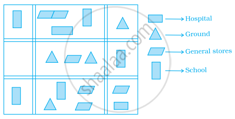
The following is the map of a town. Based on it answer question.
The number of hospitals in the town is ______.
Draw a map of your school playground. Mark all necessary places like 2 library, Playground, Medical Room, Classrooms, Assembly area, etc.
A photographer uses a computer program to enlarge a photograph. What is the scale according to which the width has enlarged?

Use a ruler to measure the distance in cm between the places joined by dotted lines. If the map has been drawn using the scale 1 cm : 10 km, find the actual distances between school and library.

Find the scale.
Actual size 45 feet
Drawing size 5 inches
