Advertisements
Advertisements
Question
How to locate epicentre of a given earthquake?
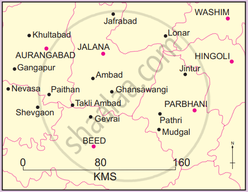
Take the given hypothetical data in the table. The data shows the time of arrival of P-waves and S-waves at 3 seismograph stations. Assume the scale of the map as 1 cm: 18 km. See figure.
| Recording Station | P-wave arrival time ( IST) | S-wave arrival time |
| Jalana | 11: 06: 06 | 11: 06: 19 |
| Washim | 11: 06: 46 | 11: 07: 03 |
| Aurangabad | 11: 07: 06 | 11: 07: 24 |
Procedure :
- Compute the time difference between the arrival of P-waves and S-waves for each station; this is called time lag. (It shows the distance of the seismograph from the focus. Thumb rule: For every second of time lag, the earthquake is approximately 8 km away.)
- Using the rule above, convert the time lag into the distance (seconds of time lag × 8) for each station.
- Convert this distance into centimetres as per the scale of the map.
- On a map, locate the seismograph stations.
- Draw circles, taking the seismograph stations as the centre, with the radius equal to the distance you have calculated in the previous step.
- These arcs of circles will intersect one another at a point. This point is the location of the epicentre.
In normal practice, an epicentre is located using computer models. The procedure outlined here is a much simplified version of what is normally done, although the principle is the same.
Solution
Speed of waves = 08 kms per second
Scale of the map = 1 cm = 18 kms
First step: Find out the difference in time for waves at Jalana recording centre.
The difference in time of waves = Time of S-wave - Time of P-wave
11 : 06 : 19 (Time of S-wave)
- 11 : 06 : 06 (Time of P-wave)
00: 00: 13
Therefore the difference in time for waves at Jalana recording centre is 13 seconds.
Second Step: Find out distance on land between Jalana and Epicentre
Distance on land = Difference in time of waves × speed of waves per second
= 13 × 8
= 104
Therefore distance on land between Jalana and Epicentre is 104 km.
Third Step: Find out radius for Jalana Station.
Jalana - Radius of circle = `"Distance on land"/"Scale of the map"`
= `104/18`
= 5.7 cm.
Therefore radius of circle around Jalana station is 5. 7 cm.
Now find out radium for remaining stations.
Jalana - 5.7 cm, Washim - 7.5 cm, Aurangabad - 8 cm,
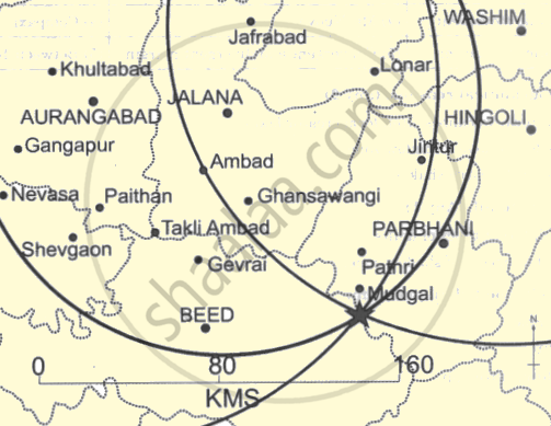
Fourth step: Now draw circles around Jalana, Washim and Aurangad with the help of radius calculated.
All arcs of the circle will intersect one another at a particular point. That point is the location of Epicentre.
In the map given below Epicentre is to the south of Mudgal.