Advertisements
Advertisements
Question
On an outline map of Australia, mark the boundaries of South Wales-Victoria border different from the other borders? Find out why.
Solution
The boundaries of all the states except South-wales and Victoria border are the same divided with a straight line.
The reason behind the border not being straight is that the majority of the border between Victoria and New South Wales is formed by the River Murray (Interestingly the river is actually in New South Wales entirely, instead of the border is right through the center of the river). It doesn’t form the border between South Australia and Vic/NSW or any of the other states as it either doesn’t run through the states or, like in South Australia, cuts right through the initial territory designated for the free colony. As they didn’t want to form another state they just kept SA as it was and had the river running through it.
But essentially, the border is formed by the Murray, which, like a river, naturally isn’t a straight line.
APPEARS IN
RELATED QUESTIONS
Give geographical reasons:
People faced many difficulties while exploring Africa.
How much time does it take the cocoa tree to yield cocoa pods?
Give an account of the major lakes of Africa.

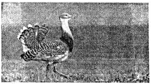
This is a photograph of a Great Bustard
- In which vegetation belt is this bird mostly found?
- Name two other animals from this vegetation belt.
Identify the hot deserts of Africa and briefly describe the climatic conditions in terms of temperature and rainfall.
Why can’t Australia’s exotic flora and fauna be found anywhere else in the world?
Identify who I am.
I have a beautiful fan-tail and I can mimic very well.
What is the name of the temperate grassland in Australia?
What are marsupials? Describe any one marsupial.
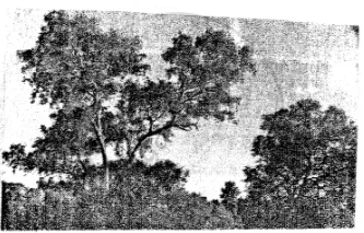
This is a photograph of a eucalyptus tree, a common tree found in Australia. There are over 900 species of this tree in Australia.

- What is the local name of this tree?
- Which animal survives by eating the leaves of this tree?
