Advertisements
Advertisements
Question
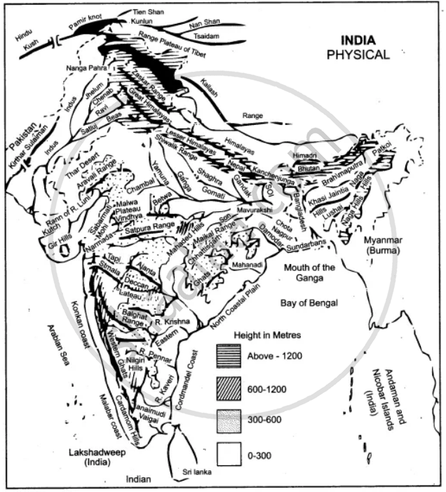
On the map of India,
(a) Label the Konkan Coast, Malabar Coast and the Coromandel Coast in their proper places.
(b) Shade and name the Rann of Kutch.
(c) Mark and name the Ajanta Range.
(d) Mark and name the Khasi-Jaintia Hills.
(e) Mark and name the Patkoi Hills.
(f) Mark and name the Naga Hills.
(g) Mark and name the Cardamom Hills.
(h) Mark and name the Annamalai Hills. Name its highest peak, Anaimudi.
Solution
APPEARS IN
RELATED QUESTIONS
On the outline map of India provided:
(a) Shade and label Thar Desert.
(b) Label the river Narmada.
(c) Shade and name the Wular Lake.
(d) Shade and label Kanara coast.
(e) Mark and name Mount Kanchenjunga.
(f) Shade and label a densely-populated region in India.
(g) Shade and label a region with Red soil in India.
(h) Mark with a dot and name Chennai.
(i) Mark and label the Arabian Sea branch of S.W. Monsoon.
(j) Mark with a dot and name Singhbhum.
On the outline map of India provided:
a) Draw, name and number the Standard Meridian.
b) Label the river Yamuna.
c) Shade and label the Gulf of Khambhat.
d) Mark and name the Nathu-La Pass.
e) Mark and name the Karakoram Range.
f) Shade and name a sparsely populated State in Northeast India.
g) Shade a region with laterite soil in Eastern India.
h) Mark with a dot and name Vishakhapatnam.
i) Mark and name the winds that bring rain to West Bengal in summer.
j) Print S on the iron mines in Singhbhum.
On the outline map of India provided:
a) Mark and name Chennai
b) Label the river Godavari
c) Shade and label the Chota Nagpur Plateau
d) Shade and name the Gulf of Kachchh
e) Mark and name the Indo Gangetic Plains
f) Shade and label the area with Red Soil
g) Mark and name the winds which bring rain to Mumbai in July and August
h) Mark and name the Satpura Range
i) Mark and name Jharia Coal Field
j) Shade and label the Northern Circar coastal region.
On the outline map of India provided:
(a) Shade and label the Gangetic Plain. [1]
(b) Shade and label an area of laterite soil in North India. [1]
(c) Mark and label the Karakoram Mountains. [1]
(d) Mark and name the Palk Strait. [1]
(e) Shade and label the river Cauveri. [1]
(f) Mark and name Mumbai. [1]
(g) Mark and name the Nathu La Pass. [1]
(h) Mark and name Digboi. [1]
(i) Shade and name the Deccan Plateau. [1]
(j) Shade and label the river Jhelum. [1]
Why is South Asia referred as Indian Sub-continent?
On the outline map of India provided:
- Draw, name and number the Tropic of Cance
- Label the river Narmada
- Shade and name Lake Chilka
- Shade and name Wular lake.
- Mark and name the Aravali Mountains
- Mark and name the Karakoram Pass
- Shade and name a densely populated state in South India
- Shade and name a region with black soil
- Mark with a dot and name Srinagar
- Mark with a dot and name Chandigarh
- Mark and name the winds which bring rain in winter to the Coromandel Coast
- Name and print O on an oilfield in North-east India.
Show the following on the outline map provided:
(a) Shade and label the Satpura Range.
(b) Label the River Krishna.
(c) Label the River Ravi.
(d) Shade and label the Khasi Hills.
(e) Mark with arrows the direction of the North-East Monsoon winds over the Bay of Bengal.
(f) Mark and label the Malabar coast.
(g) Shade and label an area of Laterite soil in India.
(h) Shade and label an area of Limestone in India.
On the map of India,
(a) Mark and name the Shiwalik Range.
(b) Mark and name, the Western Ghats with two gaps, Bhor Ghat and Palghat Gap.
(c) Mark and name the peak on the Karakoram Mts, (Mt. Godwin Austien or Mt. K2).
(d) Mark and name, the highest peak on the Himalayas, (Mt Everest).
(e) Mark and name Mt. Kanchenjunga.
(f) Mark and name the Maikal Range.
(g) Shade and name the Indo-Gangetic Plain.
Name the physical divisions into which India can be divided.
On the outline map of India provided:
- Mark and label the Satpura.
- Shade and label the Gulf of Kutch.
- Mark and label the River Chambal.
- Mark and label Delhi.
- Mark and label 80°30' E longitude.
- Mark and label Jharia Coalfield.
- Mark with arrows and name the Southwest Monsoon winds.
- Mark and label the Karakoram Pass.
- Shade and label a sparsely populated region in Western India.
- Shade an area having Alluvial soil.
