Advertisements
Advertisements
Question
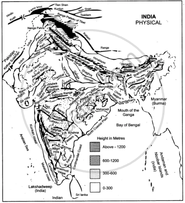
On the map of India,
(a) Label the Konkan Coast, Malabar Coast and the Coromandel Coast in their proper places.
(b) Shade and name the Rann of Kutch.
(c) Mark and name the Ajanta Range.
(d) Mark and name the Khasi-Jaintia Hills.
(e) Mark and name the Patkoi Hills.
(f) Mark and name the Naga Hills.
(g) Mark and name the Cardamom Hills.
(h) Mark and name the Annamalai Hills. Name its highest peak, Anaimudi.
Solution
APPEARS IN
RELATED QUESTIONS
On an outline map of India provided:
(a) Draw and name the Tropic of Cancer.
(b) Label the river Godavari.
(c) Mark and name the Garo Hills.
(d) Mark C on the coal fields of Jharia.
(e) Mark with an arrow and name the NE monsoon over the Bay of Bengal.
(f) Shade and name the Gulf of Kutch.
(g) Shade and name the coastal plain that receives rainfall in October and November.
(h) Mark with a dot and name Delhi.
(i) Shade a region with Black Cotton Soil.
(j) Use an arrow to point at a densely populated state in South India.
Mention any two factors which provide evidence that the region in the map extract is a rural region.
Name two features which makes Dantrai a more important settlement than the other settlement in the map extract.
Calculate the area of the region which lies to the south of northing 21 in square kilometres.
Name one region shown on the map which is unsuitable for the cultivation of crops.
On the outline map of India provided:
a) Mark and name Chennai
b) Label the river Godavari
c) Shade and label the Chota Nagpur Plateau
d) Shade and name the Gulf of Kachchh
e) Mark and name the Indo Gangetic Plains
f) Shade and label the area with Red Soil
g) Mark and name the winds which bring rain to Mumbai in July and August
h) Mark and name the Satpura Range
i) Mark and name Jharia Coal Field
j) Shade and label the Northern Circar coastal region.
On the outline map of India provided:
(a) Mark and name Chennai
(b) Label the river Godavari
(c) Shade and label the Chhota Nagpur Plateau
(d) Shade and name the Gulf of Kachchh
(e) Mark and name the Indo-Gangetic Plains
(f) Shade and label an area with Red Soil
(g) Mark and name the winds which bring rain to Mumbai in July and August
(h) Mark and name the Satpura Range
(i) Mark and name the Jharia Coal Field
(j) Shade and label the Northern Circar coastal region
On the outline map provided
(a) Label the river Chenab.
(b) Label the river Chambal.
(c) Shade and label the Nilgiri Hills.
(d) Mark and label the Eastern Ghats.
(e) Mark and name the port city of Pakistan.
(f) Mark and label Hyderabad.
(g) Shade and label the Sunderbans.
(h) Mark and name the Palk Strait.
(i) Mark and label a region North of the Tropic of Cancer where tea is grown extensively.
(j) Mark and name the winds which bring rain to Mumbai in July and August.
On the outline map provided:
(a) Shade and label the country Nepal.
(b) Shade and label an area of black soil in India.
(c) Mark and label the Konkan Coast.
(d) Shade and label one region of winter rainfall in India.
(e) Sade and label the Sulaiman Ranges.
(f) Label the River Yamuna.
(g) Label the River Tapti.
(h) Shade and label the Vindhya Ranges.
Name the physical divisions into which India can be divided.
