Advertisements
Advertisements
Question
On the map of India the cartographer forgot to draw the scale of the map. The student who knows the distance between Meerut and Delhi (70 km), was asked to complete the scale. How will the student draw the scale if he measures the distance between Delhi and Meerut on the map to be 5 cm? Give the procedure, draw the scale and find out the R.F.
Numerical
Solution
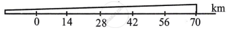
The distance on the map of 5 cm is equal to the distance of 70 km on the ground
So, 5 cm = 70 km
1 cm = `70/5` = 14 km
i.e. 1 cm = 1400000 cm
The scale is 1cm = 14 cm
R.F. = 1 : 1400000
Scale is
shaalaa.com
Is there an error in this question or solution?
