Advertisements
Advertisements
Question
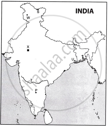
Study the sketch map given below and answer the questions that follow.

- Name the National Highways Development Project which connects the four cities marked on the map.
- Give any three reasons to justify that such transport projects strengthen the industrial economy of India.
Solution
- Golden Quadrilateral Super Highways Project.
- The following arguments support the idea that such transport initiatives boost India's industrial economy:
- Enhanced Connectivity: By connecting important industrial, agricultural, and cultural hubs, the Golden Quadrilateral project expedites and streamlines the flow of goods and services throughout the nation, cutting down on expenses and transit times.
- Increased Trade: It encourages the expansion of both domestic and international trade, increasing economic activity and investments, by facilitating better access to ports and major cities.
- Industrial Growth: India's industrial economy is strengthened as a result of the improved infrastructure, which stimulates the growth of new industries along the corridor and fosters regional development and job possibilities.
APPEARS IN
RELATED QUESTIONS
Refer to the sketch map given below and answer the question that follow:

Name the steel plant and mention its location. From where does this steel plant obtain coal and iron ore?
Refer to the sketch map given below and answer the question that follow:

Why are these iron and steel plants important?

- On the given outline map of India, mark and label the following:
- The highest range of the Himalayas.
- The northern part of the western coastal plains of India.
- The water body that lies between the peninsulas of Kachchh and Kathiawar.
- Refer to the given outline Map of India and label the following:
- The Nuclear Power Plant marked X is ______.
- The river marked T is ______.
- The state with the highest density of roads marked Y is ______.
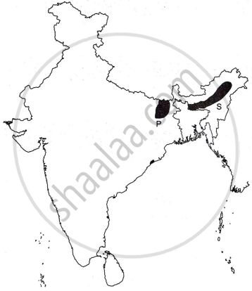
Analyse the sketch map given below which shows two flood prone regions of India marked P and S.

Explain any four causes of floods in these regions.

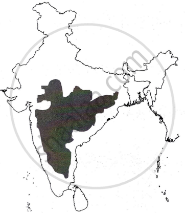
Identify the shaded part in the map given above. State any two characteristic features of this relief division. What is its significance?
Refer to the given outline Map of India and attempt subparts (i) and (ii) on map only.
- Mark and label the following on the outline Map of India.
- The northern most Trans-Himalayan Mountain range.
- The coastal plain, which runs from the south of Goa to Kanyakumari.
- The largest salt water lake on the eastern coast.
- Label the following on the outline Map of India.
- The north terminal of the ‘North-South Corridor’ marked S is ______.
- The river which originates near Mahabaleshwar marked W is ______.
- The state in India with the highest literacy marked T is ______.

Refer to the outline map of India. Identify the correct option from the ones given below and write it in the answer.

- The mountain pass located at the Indo-China border marked S is ______.
- Nathu La
- Shipki La
- Karakoram
- Bomdi La
- The port marked U which mainly exports tea, is ______.
- Visakhapatnam
- Kolkata
- Kandla
- Mumbai
- The city market P, known as Information Technology Capital of India, is ______.
- Bengaluru
- Chennai
- Ahmedabad
- Mumbai
- The terminal towns of the North-South corridor marked Wand Z are ______.
- Porbandar and Silchar
- Porbandar and Kanyakumari
- Srinagar and Kanyakumari
- Srinagar and Silchar
