Advertisements
Advertisements
Question
Think of the reason why landslides should be more frequent in the foothill zone of the Himalayas and Western Ghat region. Why do landslides not occur in Marathwada in Maharashtra or the Maidan area in Karnataka?
Solution
- The Himalayas is one of the youngest fold mountains of the world. They are formed due to the convergent movement of the Indian plate and erosion plate. They are still rising in height. These tectonic movements cause frequent earthquakes in the region resulting in landslides whereas western Ghats lie in the stable Deccan shieldless prone to landslides.
- The Himalayas are greater in height than the western Ghats. The slopes are comparatively steep and hence landslides are common in the Himalayas whereas, the Western Ghats is much lesser in height than the Himalayas hence less prone to landslides as compared to the Himalayas.
- The perennial rivers in the Himalayas carry lots of sediments during rainfall and due to the melting of glaciers in the summer thus leading to landslides, whereas, in the Western Ghats, many rivers are non-perennial and hence less amount of silt and debris in carried as compared to Himalayan rivers. Thus, there is a reduction in the chances of landslides. only during the rainy season, landslides occur in the Western Ghats region.
APPEARS IN
RELATED QUESTIONS
Identify the correct correlation:
A: Assertion; R: Reasoning
A: In areas of high rainfall, slides are very common.
R: Types of mass wasting movements are dependent on a region's climate.
Identify the correct correlation:
A: Assertion; R: Reasoning
A: Freeze and thaw weathering is common in desert areas.
R: Water gets into cracks and breaks the rocks.
Identify the correct group:
Draw a neat and labelled diagram of Freeze and thaw weathering
Draw a neat and labelled diagram of Biological weathering.
Answer in detail:
Explain with examples the process of weathering happening in Konkan.
In which regions will freeze-thaw weathering not be effective?
Can animals and plants also influence weathering? Will that be physical or chemical weathering? Which type of weathering does stone quarrying cause?
The satellite images are given in figure A and B belong to the same location but a different timeline. Study the images and answer the following questions.

Figure A
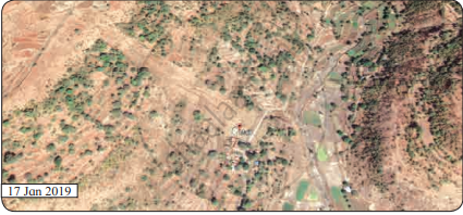
Figure B
- Compare the images and tell what differences do you find in these images.
- In 2019 what does the patch of land going from north-west to south-east signify? Why was it not there in the 2011 image?
- To what extent is the climate of the place responsible for this disaster?
- Which other factors are responsible for the disaster?
Study the following schematic diagram. It shows the relationship between the speed of material and moisture content. Read the index, and answer the following questions:

- Fast
- Slow
- Dry
- Wet
- Creep
- Slide
- Fall
- Flow
Question:
- What will happen when the weather conditions are dry?
- When will a flow occur?
- When will a creep occur?
- Now can you enumerate the factors which affect mass wasting?
