Advertisements
Advertisements
Question
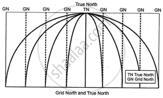
Why are 'True North' and 'Grid North' different?
Solution
Semi-circular lines of longitude are often depicted as straight on maps. The represented North is Grid North. The earth's spherical shape creates a difference from True North.

APPEARS IN
RELATED QUESTIONS
Write True or False. Correct the false statement.
Land use refers to the way a piece of land is used in the area.
Fill in the blanks. One has been done for u
| Distance on the map | Distance on the gound | Scale |
| 5 cm | 25 km | 1 cm = 5 km |
| 10 cm | 100 km | ___________ |
| 2 cm | ________ | 1 cm = 30 km |
| _________ | 49 m | 1 cm = 7 m |
| 6 cm | 60,000 km | __________ |
Match the following
| A | B | ||
| 1 | Scale | (i) | Words |
| 2 | Statement scale | (ii) | Straight Line divided into lengths |
| 3 | Linear Scale | (iii) | Curved line |
| 4 | ruler | (iv) | Ratio |
| 5 | twine | (v) | Straight Line |
Describe the method by which the distance on a curved line is measured.
How is a distance on a map measured by a piece of twine?
With regard to scale, answer the following questions:
Convert the statement into R.F. `2 1/2` inches on the map = 5 miles on ground.
With regard to scale, answer the following question:
Convert the statement into R.F. 7 cm on the map = 63000 meters on ground.
With regard to scale, answer the following question:
Convert the following statement into R.F.
15 cm = 6 km
Convert the following representative fraction into statement:
1 : 63360 (to show miles).
Convert the following representative fraction into a statement:
1 : 10 (to show metres)
