Advertisements
Advertisements
Question
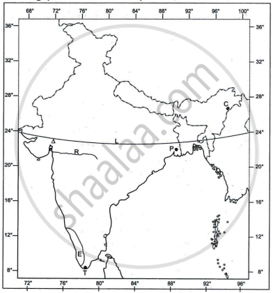
With reference to the extent of India, write the angular values of the points marked as (a), (b), (c) and (d) in the map given below :

Solution
(a) Western longitude 68° 7′ East.
(b) Standard Meridian 82° 30′ East.
(c) Eastern Longitude 97° 25′ East.
(d) Tropic of cancer 23° 30′ North.
APPEARS IN
RELATED QUESTIONS
With reference to river Godavari, name the following :
The State where it originates.
Answer the following question:
Explain the term braided river. Give an example.
Answer the following question:
Name any two narrow gauge railway lines present in the Himalayan region.
Answer the following question.
Name any two major ports located on the Western Coast of India.
Name the following :
An important hill resort of West Bengal.
Answer the following question:
Define the terms Lagoon and Delta with an example of each from the Indian region.
With reference to river Godavari, name the following :
The State where it forms its delta.
Refer to the outline Map of India provided and answer the following questions on the Map:

- Mark and label the following on the given map of India.
- The coastal plain that receives rainfall from Northeast monsoons.
- The oldest mountain range of India.
- The plateau rich in minerals in India.
- The angular value of the latitude marked L is ______.
- 37°4' N
- 68°7' N
- 8°4' N
- 23°30' N
- The riverine port marked P is ______.
- Kolkata
- Kochi
- Vishakhapatnam
- Chennai
- The cotton textile centre marked by the Δ is ______.
- Mumbai
- Coimbatore
- Pune
- Ahmedabad
- The state marked E has the highest ______.
- literacy rate.
- index of concentration of population.
- density of population
- level of urbanisation.
- Identify the following:
- The city marked T, which is one of the terminals of the North-South corridor, is ______.
- The oldest oilfield of India marked C is ______.
- The west flowing river marked R between the Vindhyas and the Satpura range is ______.
River Brahmaputra is a tributary of River Ganga.
Assertion: The rivers on the western coast carry a lot of sediments but do not form a delta.
Reason: They have a large catchment area and form estuaries.
