Advertisements
Advertisements
Question
With regard to scale, answer the following question:
Name the main methods of representing the scale of a map.
Answer in Brief
Solution
There are three main methods of representing scale.
- A statement scale: This method involves stating the scale in words, such as 1 cm to 1 km or 1 inch to 5 miles. The figure on the left side often represents the map distance. This method is unsuitable because we need to know the units of measurement in different nations.
- Liner or Graphic Scale: This method uses a straight line divided into equal sections (primary and secondary) to indicate the scale on the ground. The primary Divisions are the major divisions of the scale, arranged from left to right. Secondary Divisions are smaller entities organised from right to left within a primary division.
- Representative Fraction: This method represents scale as the ratio of a line's length on a map to its actual distance on the earth's surface. The numerator is usually expressed as unity, which means that one unit of map-distance equals a number of units of ground-distance. This fraction is referred to as the representative fraction.
shaalaa.com
Map Scale
Is there an error in this question or solution?
Chapter 3: Scales and Direction - EXERCISES [Page 28]
APPEARS IN
RELATED QUESTIONS
After studying the picture have a discussion in the class and answer the following questions.
- Why is the painter holding the pencil in his hand in a particular way?
- How can the scene of this large landscape be depicted on paper?
- How is it possible to view all the countries of the world on one map?
- What is common to both these pictures?
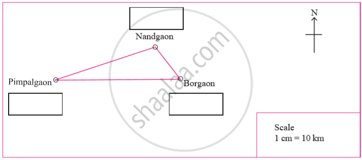
The actual distance between the two villages of Sahil and Minal is 50 km. The distance between the villages of Minal and Pragnya is 20 km and between Sahil and Praghya’s villages is 60 km. Figure given below shows the location of these villages on a map. The scale of the map is 1 cm = 10 km. Measure the distances on the map and find out which village belongs to whom? Note the names and the distances.

