Advertisements
Chapters
2: Scale and Distance
3: Composition and Structure of the Atmosphere
4: Greenhouse Effect and Global Warming
5: Study of Weather
6: Recording of Weather
7: Types of Rocks
8: Weathering and Soil
9: Industries: Their Need, and Classification
10: Major Industries
11: Renewable and Non-renewable resources
12: Europe: Location, Area, Political & Physical Features
13: Europe: Climate, Natural Vegetation, Wildlife; Forest, Minerals & Power Resources
14: Africa: Location, Area, Political & Physical Features
15: Africa: Climate, Natural Vegetation, Wildlife; Minerals
16: Australia:Location,Area, Political & Physical Features
17: Australia: Climate, Natural Vegetation, Wildlife; Forest and Minerals
18: Antarctica: Location, Physical Features, Climate, Natural Vegetation
![Oxford University Press solutions for Voyage Geography [English] Class 7 chapter 1 - Topographical Sheets: Colours, Signs and Symbols - Shaalaa.com](/images/voyage-geography-english-class-7_6:4256ba090345470c9fead663b561899f.jpg "Oxford University Press solutions for Voyage Geography [English] Class 7 chapter 1 - Topographical Sheets: Colours, Signs and Symbols")
Advertisements
Solutions for Chapter 1: Topographical Sheets: Colours, Signs and Symbols
Below listed, you can find solutions for Chapter 1 of CISCE Oxford University Press for Voyage Geography [English] Class 7.
Oxford University Press solutions for Voyage Geography [English] Class 7 1 Topographical Sheets: Colours, Signs and Symbols Think and Answer
If maps were only black and white, will they be difficult to read?
Oxford University Press solutions for Voyage Geography [English] Class 7 1 Topographical Sheets: Colours, Signs and Symbols Values and Life Skills
Using colours and symbols is an intelligent way of providing information. It helps cartographers to make beautiful and easy-to-read maps.
Can you think of a situation where you can use this method in your day-to-day life?
Oxford University Press solutions for Voyage Geography [English] Class 7 1 Topographical Sheets: Colours, Signs and Symbols Fill in the blanks
Fill in the blank
Mountains, hills, rivers, etc. are ______features shown on a map
Fill in the blank
Roads, rail tracks, wells, etc. are ________ features on a map.
Fill in the blank
Contour lines on a map join points of equal ______ on the surface or the earth above or below a reference point.
Fill in the blank
The colour ____________ is used to show barren land on topographical sheets.
Fill in the blank
The colour yellow is used to show ______________ on topographical sheets.
Oxford University Press solutions for Voyage Geography [English] Class 7 1 Topographical Sheets: Colours, Signs and Symbols Match the following
Match the following:
| Column A | Column B |
| 1. Camping Ground | (i)  |
| 2. Seasonal streams |
(ii) |
| 3. Palms | (iii) |
| 4. River | (iv) |
| 5. Footpath | (v) |
Oxford University Press solutions for Voyage Geography [English] Class 7 1 Topographical Sheets: Colours, Signs and Symbols Write True or False
Write True or False. Correct the false statement.
The distance between the two tracks in a broad gauge is 1 m.
True
False
Write True or False. Correct the false statement.
A metalled road is shown by two blue lines
True
False
Write True or False. Correct the false statement.
Settlements can either be temporary or permanent.
True
False
Write True or False. Correct the false statement.
In permanent settlements, houses are built for a short period of time.
True
False
Write True or False. Correct the false statement.
Terrace farming is undertaken on hilly slopes.
True
False
Write True or False. Correct the false statement.
Land use refers to the way a piece of land is used in the area.
True
False
Oxford University Press solutions for Voyage Geography [English] Class 7 1 Topographical Sheets: Colours, Signs and Symbols Answer the questions briefly
What are topographical maps?
What is a contour line?
Explain why colours are used in topographical maps.
Name the features shown in blue, green, and brown colours on a map.
How would you recognize a metalled road and an unmetalled one on a topographical map?
What do you understand by settlements?
Distinguish between a temporary settlement and a permanent settlement.
Oxford University Press solutions for Voyage Geography [English] Class 7 1 Topographical Sheets: Colours, Signs and Symbols Answer the questions in one or two paragraphs
How can the occupation of people be inferred directly from a topographical sheet?
How can topographical maps help us to know about the transport and communication of an area?
How does relief of an area affect land use?
Oxford University Press solutions for Voyage Geography [English] Class 7 1 Topographical Sheets: Colours, Signs and Symbols Exercise
Draw a sketch map of your neighborhood using different colours for different areas, for example, red for residential areas, green for parks and playgrounds, and yellow for commercial areas. Use symbols to mark out roads and special places like temples, post offices, old monuments, or railway stations. Make a proper key for it.
Oxford University Press solutions for Voyage Geography [English] Class 7 1 Topographical Sheets: Colours, Signs and Symbols Picture study
Look at the symbols given here and answer the following question.
What does symbols 1 and 2 show?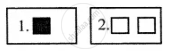
Look at the symbols given here and answer the following question.
How do the features shown by these two symbols differ?
Oxford University Press solutions for Voyage Geography [English] Class 7 1 Topographical Sheets: Colours, Signs and Symbols Let's Do Something
Form a group in your class and obtain a topo sheet from the Geography Department of your school. Look at it carefully and identify the following features :
- settlements
- railway lines
- agricultural fields
- roads
Solutions for 1: Topographical Sheets: Colours, Signs and Symbols
Oxford University Press solutions for Voyage Geography [English] Class 7 chapter 1 - Topographical Sheets: Colours, Signs and Symbols
Shaalaa.com has the CISCE Mathematics Voyage Geography [English] Class 7 CISCE solutions in a manner that help students grasp basic concepts better and faster. The detailed, step-by-step solutions will help you understand the concepts better and clarify any confusion. Oxford University Press solutions for Mathematics Voyage Geography [English] Class 7 CISCE 1 (Topographical Sheets: Colours, Signs and Symbols) include all questions with answers and detailed explanations. This will clear students' doubts about questions and improve their application skills while preparing for board exams.
Further, we at Shaalaa.com provide such solutions so students can prepare for written exams. Oxford University Press textbook solutions can be a core help for self-study and provide excellent self-help guidance for students.
Concepts covered in Voyage Geography [English] Class 7 chapter 1 Topographical Sheets: Colours, Signs and Symbols are Use of Colours on Topographical Sheets, Use of Scales for Measurement, Measuring Distance on the Map Using Scales, The Role of Standard Signs and Symbols in Map Interpretation.
Using Oxford University Press Voyage Geography [English] Class 7 solutions Topographical Sheets: Colours, Signs and Symbols exercise by students is an easy way to prepare for the exams, as they involve solutions arranged chapter-wise and also page-wise. The questions involved in Oxford University Press Solutions are essential questions that can be asked in the final exam. Maximum CISCE Voyage Geography [English] Class 7 students prefer Oxford University Press Textbook Solutions to score more in exams.
Get the free view of Chapter 1, Topographical Sheets: Colours, Signs and Symbols Voyage Geography [English] Class 7 additional questions for Mathematics Voyage Geography [English] Class 7 CISCE, and you can use Shaalaa.com to keep it handy for your exam preparation.
