Topics
Earth Movements
- Earth Movements
- Evidences of Earth Movements
- Slow Earth's Movements
- Folding
- Faulting
- Sudden Movements
- Earthquake
- Shadow Zone of an Earthquake
- Volcanoes
- Volcanic Materials
- Volcanic Landforms
- Earthquake Zones of the World
- Distribution of Volcanoes in the World
Weathering and Mass Wasting
- Introduction of Weathering and Mass Wasting
- Weathering
- Types of Weathering
- Different Rates of Weathering
- Importance of Weathering
- Mass Movements (Mass Wasting)
- Types of Mass Wasting
- Erosion
Agents of Erosion
- Introduction of Agents of Erosion
- Agents of Erosion and Landforms
- Work of River
- Work of Sea Waves
- Work of Winds
- Work of Groundwater
- Erosional and Depositional Landforms
- Work of Glacier
Climatic Regions
- Climatic Regions
- Classification of Climate and Identifying Climatic Regions (Natural Regions)
- Low-latitude Regions
- Equatorial Rainforests
- Tropical Monsoon Climate
- Tropical Savannah Type of Climate
- Tropical Deserts or Arid Type of Climate
- Mid-latitude Regions
- Mediterranean Climate
- China Type Climate or Humid Sub Tropical Climate
- Marine West European Type Climate
- High Latitudinal Regions
- Taiga or Sub-Arctic
- Tundra Climate
- Ice Sheet
- High-altitude Regions
- Highland or Mountain Type
Global Climate Change
- Introduction of Global Climate Change
- Causes of Climate Change
- Is Climate Change Happening for the First Time?
- Some Tools for Studying Climate Change
- Measures to Combat Climate Change
- Climate Change and India
- Lifestyle Changes and Climate Change
Ocean Resources
- Introduction of Ocean Resources
- The Structure of Ocean Floor
- Ocean Resources
- Use of Oceans for Other Purposes
- Who Owns the Oceans?
- International Resources
- Marine Pollution
Indian Ocean - Relief and Strategic Importance
- Indian Ocean Region
- Bottom Relief of Indian Ocean
- Continental Shelf
- Mid-oceanic Ridges
- Islands of Indian Ocean
- Ocean Basins
- Deeps and Trenches
- Distribution of Temperature and Salinity in Indian Oceans
- Indian Ocean Salinity
- Ocean Currents in Indian Ocean
- Importance of the Indian Ocean
- The Importance of Indian Ocean for India
Biomes
- Biomes
- Difference Between Biomes and Ecosystem
- Terrestrial Biomes
- Tropical Rainforest Biome
- Tropical Decidouos Biome
- Savannah Grassland Biome
- Tropical Desert Biome
- Mediterranean Biome
- Temperate Deciduous Biome
- Temperate Grasslands Biome
- Taiga Biome
- Tundra Biome
- Mountain Or Highland Biome
Disaster Management
- Disaster
- Types of Disaster
- Hazards
- Vulnerability
- Capacity to Cope
- Effects of Disaster
- Disaster Management
- Disaster Management Cycle
- Role of Remote Sensing, GIS and GPS in Disaster Management
- Disaster Management in India
- Introduction
- Focus and Epicenter
- Intensity of Earthquakes
- Types of Seismic Waves
- Measuring Earthquakes
- Causes and Effects of Earthquakes
- Precautions During an Earthquake
- Earthquake Resistant / Proof Buildings
- Modern Equipment for Earthquake Detection
Introduction:
An earthquake occurs when there are movements deep inside the earth. These movements release a lot of energy, which creates seismic waves. These waves cause the Earth's surface to tremble, shake, and sometimes even crack. The shaking or vibrations that occur on the earth’s crust are called earthquakes.
- Movements inside the Earth cause a release of energy, which travels in the form of seismic waves. These waves reach the earth's surface, causing the ground to shake or tremble.
- Earthquakes can occur naturally, but sometimes human activities like mining or building large dams can also lead to earthquakes.
Focus and Epicenter:
When an earthquake happens, there are two essential terms to know
- Focus: The focus is the exact point inside the earth where the earthquake starts. It's the source of the earthquake, deep below the ground.
- Epicentre: The epicentre is the point on the Earth’s surface directly above the focus. Because it is closest to the focus, the strongest shaking is usually felt at the epicentre. The strongest shaking occurs at or near the epicentre, often causing the most damage to buildings and infrastructure.
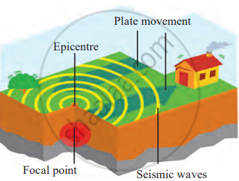
Focal point and epicentre of earthquake
Intensity of Earthquakes:
Earthquake shocks can range from very mild to extremely strong.
- Mild earthquakes are those that cause little to no damage and are often barely felt by people. These mild earthquakes occur frequently around the world.
- Strong earthquakes, on the other hand, are powerful enough to cause significant destruction. They are less common but are more dangerous.
Every day, many small earthquakes are recorded around the world. According to the National Earthquake Information Centre, between 12,400 and 14,000 earthquakes occur each year worldwide. This means that the earth is always experiencing some level of vibration.
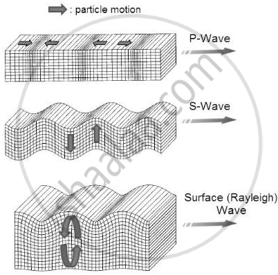
Types of Seismic Waves:
During an earthquake, seismic waves travel through the Earth. There are three main types of seismic waves:
- Primary or ‘P’ Waves: P waves are the fastest seismic waves and the first detected during an earthquake. They move through the Earth’s interior in a push-pull motion, similar to sound waves. These waves can travel through both solid and liquid layers of the earth.
- Secondary or ‘S’ Waves: S waves are slower than P waves and arrive second. They move in a side-to-side or up-and-down motion. S waves can only travel through solid layers, not liquids.
- Surface or ‘L’ Waves: L waves are the slowest and last waves to be felt. These waves travel along the Earth’s surface and cause the most damage because they create strong shaking on the ground. L waves move in a rolling motion, which can cause buildings and roads to crack or collapse.
Measuring Earthquakes:
1. Seismometer
A seismograph (or seismometer) is a device used to detect and record earth movements. It has three main parts: a heavy weight, a pen, and a base. The base is fixed to the ground and moves during an earthquake, while the suspended weight stays mostly still. This causes the pen to draw lines on a rotating drum, creating a seismogram.
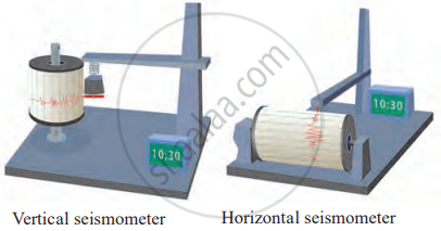
Seismometer
- It provides a detailed record of ground shaking. And helps scientists determine the earthquake’s intensity and duration.
- Data from multiple seismographs can locate the earthquake’s origin.
2. Richter Scale
The Richter Scale measures the magnitude (strength) of an earthquake, indicating how much energy is released at its source. Developed in 1935 by Charles F. Richter, it uses a logarithmic scale, meaning each whole number increase represents 10 times greater wave amplitude and about 32 times more energy released.
- Magnitude is calculated using the height of seismic waves recorded by a seismograph.
- An earthquake with a magnitude of 5.0 is 10 times stronger in wave amplitude than one with a magnitude of 4.0 and releases 32 times more energy.
Magnitude Categories,
| Less than 2.0 | Microearthquakes, usually not felt. |
| 2.0 to 3.9 | Minor, often felt but rarely damaging. |
| 4.0 to 4.9 | Light, felt by many with minimal damage. |
| 5.0 to 5.9 | Moderate may damage poorly built structures. |
| 6.0 to 6.9 | Strong, significant damage is possible. |
| 7.0 to 7.9 | Major, causing severe damage over large areas. |
| 8.0 and above | Great, with catastrophic and widespread destruction. |
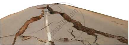
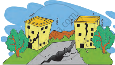
Causes and Effects of Earthquakes:
| Causes of an Earthquake | Effects of an Earthquake |
|---|---|
| 1. Volcanic eruption | 1. Loss of human beings, wild animals, and pets. |
| 2. Stress of big dams on the earth | 2. Economic loss on a large scale (destruction of electric poles, pipelines, houses, buildings, roads, and railway tracks). |
| 3. Mining | 3. Ecosystem destruction due to the loss of biodiversity. |
| 4. Underground atomic tests | 4. The direction of the flow of rivers and streams changes. |
| 5. Water percolates through the cracks of the earth. Due to tremendous heat, the water converts into steam. The steam tries to come out from the loosened earth surface, causing earthquakes. | 5. Increased possibility of fires in cities. |
| 6. Tectonic plate movements | 6. If the earthquake occurs at the bottom of the ocean, it may create tsunami waves, leading to large-scale destruction of coastal regions. |
| 7. Fault line activity | 7. Changes in the level of the water table. |
| 8. Construction blasting | 8. Landslides that bury roads and destroy property. |
| 9. Geothermal energy extraction | 9. Soil liquefaction that destabilises structures. |
| 10. Oil and gas drilling | 10. Contamination of water supplies due to broken pipelines. |
| 11. Fracking (hydraulic fracturing) | 11. Psychological trauma and displacement of populations. |
| 12. Rapid glacial melting (causing shifts in land masses) | 12. Disruption of transportation and communication systems. |
Precautions During an Earthquake:
1. If You're at Home
- Stay calm and don’t run. Stand still or sit on the floor.
- Hide under sturdy furniture like a table or bed and protect yourself until the shaking stops.
- If there’s no furniture, sit in a corner and cover your head with your hands.
2. If You're Outside or in a Vehicle
- Park your vehicle in a safe spot and stay inside.
- Stay away from tall buildings, trees, and electric poles.
3. Other Precautions
- Don’t use lifts; use the stairs instead, especially in tall buildings.
- Avoid staying still for too long; move your body to stay comfortable and alert.
- Turn off the main electric supply carefully to prevent fires.
- Use a flashlight or battery instead of candles, lanterns, or matches.
Earthquake Resistant / Proof Buildings:
Earthquake-resistant buildings are specially designed to withstand seismic forces, minimising damage and ensuring safety. They are built to handle ground shaking up to a certain intensity, reducing the risk of collapse.
Design and Construction Standards:
1. Building Codes
- IS 456: Guidelines for strong and durable reinforced concrete structures.
- IS 1893: Principles for designing buildings to endure earthquakes.
- IS 13920: Reinforcement guidelines to keep buildings flexible and ductile, allowing them to bend without breaking.
2. Advanced Techniques
- Base Isolation: Using flexible bearings to separate buildings from foundations, reducing seismic force impact.
- Energy Dissipation Devices: Absorb and reduce earthquake energy.
- Reinforced Frames & Flexible Joints: Allow controlled movement during earthquakes.
Modern Equipment for Earthquake Detection:
- Laser Ranging & VLBI: Measure ground shifts with precision.
- Geiger Counters: Detect underground activity related to earthquakes.
- Creep Meters & Strain Meters: Track ground movement and crust deformation.
- Tide Gauges & Tilt Meters: Monitor sea level changes and ground tilt, signalling possible seismic events.
- Volumetric Strain Gauges: Measure changes in volume within the earth's crust to detect seismic stress.
