Advertisements
Advertisements
प्रश्न
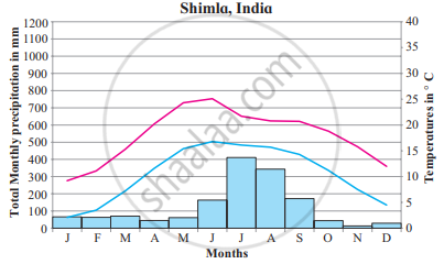
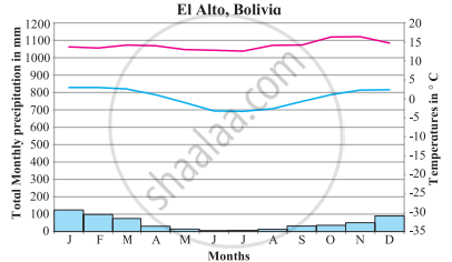
Read the graphs figure a and b and answer the following questions. Locate the places on the map:
- Which are the warmest and the coolest months?
- Name the months of highest and lowest precipitation.
- In what way do you find similarities in this climate with other climate types of high latitudes?
- Why are the axes showing temperatures different in both the graphs?
- What factors influence this type of climate?
टिप्पणी लिखिए
उत्तर
- The warmest month is June while the coolest month is January in Shimla. November is the hottest month and July is the coolest month in El Alto.
- Most of the precipitation is in the months of July, whereas the driest month is November is in Shimla. Precipitation is highest in January and the lowest in June in El Alto.
- In these regions, precipitation is in the form of snowfall. The regions are covered by snow. Temperature is very low, as the sunrays are oblique and little insolation is received. Temperature decreases with increasing altitude.
- Shimla is located at 31°6 N to 77°10 and its elevation is 2.276 m whereas El Alto is located on 16°31 S to 68°10 W with an elevation of 4.150 mts. Temperature decreases with increasing altitude. Thus, the axis is a different temperature in both the graphs.
- The higher reaches of mountain, altitude, location of leeward or windward side, precipitation are the factors affecting climates of mountain type of climate.
shaalaa.com
High-altitude Regions - Highland or Mountain Type
क्या इस प्रश्न या उत्तर में कोई त्रुटि है?


