Advertisements
Chapters
![Balbharati solutions for Geography (Social Science) [English] 11 Standard chapter 4 - Climatic Regions Balbharati solutions for Geography (Social Science) [English] 11 Standard chapter 4 - Climatic Regions - Shaalaa.com](/images/geography-social-science-english-11-standard_6:acdc1b8f00d74d0085a22ac1e29ad6d2.jpg)
Advertisements
Solutions for Chapter 4: Climatic Regions
Below listed, you can find solutions for Chapter 4 of Maharashtra State Board Balbharati for Geography (Social Science) [English] 11 Standard.
Balbharati solutions for Geography (Social Science) [English] 11 Standard 4 Climatic Regions Use your brain power! [Pages 44 - 56]
- Have you ever thought why there is a difference in the skin color of various peoples in the world?
- Why all the people in the world do not eat the same food?
- Why there is a variety of clothing patterns and types too? Even our houses are different.
- How come flora and fauna are restricted to a particular region?
- Why different fruits are found in different places?
- What would be the annual range of temperature in the equatorial region?
- Where is the tropical rainforest climate type of climate found in India?
Comment upon the type of weathering which will occur in the Tropical Monsoon Climate region.
- Which agricultural crops are produced Savannah region?
- Why are longitudes not given in geographical distribution?
Comment upon the rate of weathering in the arid climate.
Why do people in Europe use olive oil for cooking?
What factors make humid subtropical climate agriculturally productive?
- Why does Chile recur frequently in examples of geographical distribution?
- Why has fishing developed in Chile?
- What would be the annual range of temperature in Taiga or Sub-Arctic? What could be the occupational activities carried out by humans here?
- What type of weathering will be prominent in the Taiga or Sub-Arctic region?
What kinds of mass movement may happen in the Tundra region?
- What kind of activities will bring people from other regions to the ice cap climate?
- What could be the occupations followed in the ice cap climate?
- What type of human activities will develop in the High-altitude regions?
- In what ways might high latitudes be different from high altitudes?
Balbharati solutions for Geography (Social Science) [English] 11 Standard 4 Climatic Regions Can you tell? [Pages 44 - 56]
Make a list of the human activities you think that are not influenced by climatic elements. Let us see how far you can proceed.
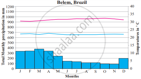
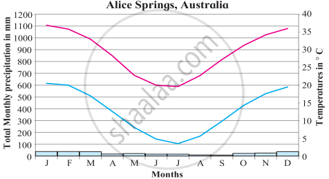
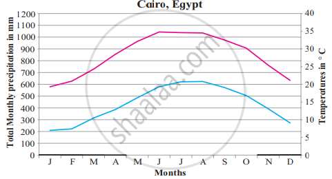
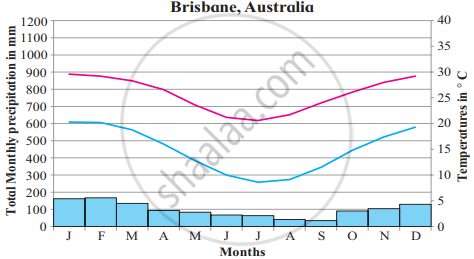
Read the graphs of figure a and b and answer the following questions. Locate the places on the map:
- In which months there is no rainfall?
- In which month is the temperature highest?
- In which month is the temperature lowest?
- What could be the factors which influence the climate of these places?
- Write a concluding statement about the climate of both the places based on the questions above.
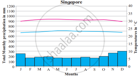
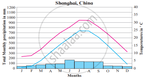
Read the graphs figure a and b and answer the following questions. Locate the places on the map:
- Name the months of highest and lowest rainfall. What is the difference between the values of rainfall?
- Name the months of the highest and the lowest temperatures.
- Are the months of rainfall the same in both places? If not, why?
- What could be the factors which influence the climate of these places?
- What difference do you find between the graphs in figure b) and figure a)?
- Write a concluding statement about the climate of both places?
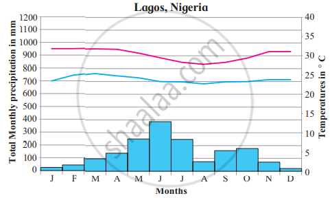
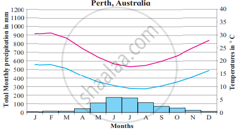
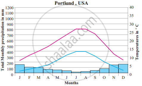
Read the graphs figure a and b and answer the following questions. Locate the places on the map:
- In which months is there no rainfall?
- In which month is the temperature highest?
- In which month is the temperature lowest?
- Are the months of rainfall the same in both places? If not, why?
- What could be the factors which influence the climate of these places?
- What difference do you find between the previous and these graphs?
- Write a concluding statement about the climate of both places.
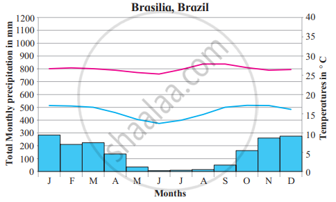
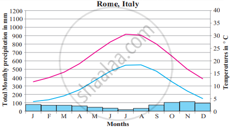
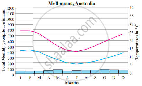
Read the graphs figure a and b and answer the following questions. Locate the places on the map:
- Name the months of highest and lowest rainfall. What is the difference between the values of rainfall?
- Name the months of highest and lowest temperatures.
- Are the months of rainfall the same in both places? If not, why?
- What could be the factors which influence the climate of these places?
- What difference do you find between the previous and these graphs?
- Write a concluding statement about the climate of both the places.
Read the graphs figure a and b and answer the following questions. Locate the places on the map:
- Name the months of the highest rainfall.
- Name the months of lowest temperatures.
- Are the answers to 1 and 2 the same?
- Are the months of rainfall the same in both places? If not, why?
- What could be the factors which influence the climate of these places?
- What difference do you find between the previous and these graphs?
- Write a concluding statement about the climate of both places.
Read the graphs figure a and b and answer the following questions. Locate the places on the map:
- Name the months of highest and lowest rainfall.
- Name the months of highest and lowest temperatures. Relate them with rainfall months.
- Are the months of rainfall the same in both places? If not, why?
- What could be the factors which influence the climate of these places?
- What difference do you find between the previous and these graphs?
- Write a concluding statement about the climate of both places.
Read the graphs figure a and b and answer the following questions. Locate the places on the map:
- In which months do you find the temperature is the lowest?
- In which months is the precipitation the lowest?
- What are the highest values of precipitation?
- Name the months with no precipitation at all.
- Write a concluding paragraph about these climatic regions.
Read graphs a and b and answer the following questions. Locate the places on the map:
- Note the values of the axes. How different are these graphs from the earlier ones?
- Note the highest and the lowest temperatures and their months
- Note the highest and the lowest rainfall and their months.
- Why does not a place from Southern Hemisphere appear here?
- What factors are responsible for this climate?
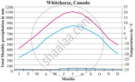
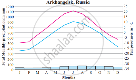
Read the graphs figure a and b and answer the following questions. Locate the places on the map:
- Why is it that both the graphs are from the Northern Hemisphere?
- Which are the warmest and the coolest months?
- What is the annual range of temperature?
- Why does not the duration of the day (sometimes more than 24 hours) influence its temperatures or precipitation?
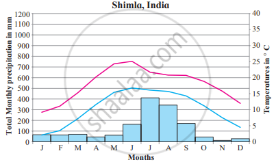
Read the graphs figure a and b and answer the following questions. Locate the places on the map:
- Which are the warmest and the coolest months?
- Name the months of highest and lowest rainfall.
- In what way do you find similarities in this climate with other climate types of high latitudes?
- What factors influence this type of climate?
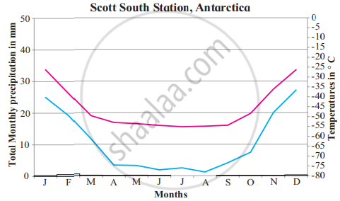
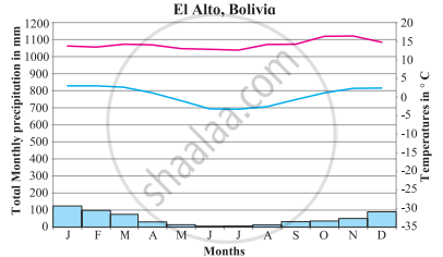
Read the graphs figure a and b and answer the following questions. Locate the places on the map:
- Which are the warmest and the coolest months?
- Name the months of highest and lowest precipitation.
- In what way do you find similarities in this climate with other climate types of high latitudes?
- Why are the axes showing temperatures different in both the graphs?
- What factors influence this type of climate?
Balbharati solutions for Geography (Social Science) [English] 11 Standard 4 Climatic Regions Find out ! [Page 44]
Use the Internet or reference books to find out about the attempts at classification of climates.
Balbharati solutions for Geography (Social Science) [English] 11 Standard 4 Climatic Regions Exercise [Page 57]
Write the names of climatic regions according to the factors that dominate their characteristics.
| Latitudinal location | Winds and wind systems | Proximity to sea | a Continental location | Altitude |
Choose the correct alternative:
Monsoon region
- annual average temperature around 27° C
- >2500 mm annual precipitation
- Indonesia
- Hard-wood evergreen trees
- Average temperature in Summers around 27°C to 32°C
- < 2500 mm annual rainfall
- Southeast Asia
- Hardwood deciduous trees
- Temperatures in summer around 35° C
- 1000 mm annual rainfall
- Continental part of the Indian peninsula
- Tall and thick grass
- Average temperatures in summer around 27° C
- 1000 mm rainfall in winter
- South Africa
- Hard–wooded, waxy, evergreen forests
Choose the correct alternative:
The region with a high diurnal range of temperature:
Tropical rainforests
Tropical grasslands
Tropical desert regions
Tropical Monsoon regions
Choose the correct alternative:
Lumbering flourished as an occupation from Newfoundland to Alaska in North America because:
Tundra Climatic Region
Taiga Climatic Region
West European Climatic Region
China-type climatic region
Choose the correct alternative:
The main reason behind the months of precipitation in the graphs of Monsoon climatic regions being different is:
ITCZ
orographic rainfall
hemispheres are different
the apparent movement of the sun
Give a geographical reason:
In the Monsoon climate region, rainfall occurs in a specific season.
Give a geographical reason:
Taiga region is not found in Southern Hemisphere.
Give a geographical reason:
The diurnal range of temperature is more in desert areas.
Give a geographical reason:
There is no concept of the season in equatorial regions.
Give a geographical reason:
The Savannah region is prone to droughts.
Give a geographical reason:
Though Mussoorie and Dehradun are located on the same latitude, why is their climate different?
Differentiate between :
Rainforests and Savannah Climatic Regions
Differentiate between:
Taiga and Tundra regions
Differentiate between Monsoon and Mediterranean Regions.
Answer in detail:
Explain, with examples, the effect of latitude on a place’s climate.
Answer in detail:
Explain, with examples, how winds affect the climate of a place.
Answer in detail:
Russia is larger than Chile in the area but does not experience climatic diversity as Chile. Explain.
Answer in detail:
Explain the factors affecting the climate of a place giving examples.
On a world map, show the following areas:
- Savannah climatic region in Africa
- Highland climatic region in India
- Chile and Russia
- Icecap climatic region
- Desert climatic region
Solutions for 4: Climatic Regions
![Balbharati solutions for Geography (Social Science) [English] 11 Standard chapter 4 - Climatic Regions Balbharati solutions for Geography (Social Science) [English] 11 Standard chapter 4 - Climatic Regions - Shaalaa.com](/images/geography-social-science-english-11-standard_6:acdc1b8f00d74d0085a22ac1e29ad6d2.jpg)
Balbharati solutions for Geography (Social Science) [English] 11 Standard chapter 4 - Climatic Regions
Shaalaa.com has the Maharashtra State Board Mathematics Geography (Social Science) [English] 11 Standard Maharashtra State Board solutions in a manner that help students grasp basic concepts better and faster. The detailed, step-by-step solutions will help you understand the concepts better and clarify any confusion. Balbharati solutions for Mathematics Geography (Social Science) [English] 11 Standard Maharashtra State Board 4 (Climatic Regions) include all questions with answers and detailed explanations. This will clear students' doubts about questions and improve their application skills while preparing for board exams.
Further, we at Shaalaa.com provide such solutions so students can prepare for written exams. Balbharati textbook solutions can be a core help for self-study and provide excellent self-help guidance for students.
Concepts covered in Geography (Social Science) [English] 11 Standard chapter 4 Climatic Regions are Climatic Regions, Classification of Climate and Identifying Climatic Regions (Natural Regions), Low-latitude Regions, Equatorial Rainforests, Tropical Monsoon Climate, Tropical Savannah Type of Climate, Tropical Deserts or Arid Type of Climate, Mid-latitude Regions, Mediterranean Climate, China Type Climate or Humid Sub Tropical Climate, Marine West European Type Climate, High Latitudinal Regions, Taiga or Sub-Arctic, Tundra Climate, Ice Sheet, High-altitude Regions, Highland or Mountain Type.
Using Balbharati Geography (Social Science) [English] 11 Standard solutions Climatic Regions exercise by students is an easy way to prepare for the exams, as they involve solutions arranged chapter-wise and also page-wise. The questions involved in Balbharati Solutions are essential questions that can be asked in the final exam. Maximum Maharashtra State Board Geography (Social Science) [English] 11 Standard students prefer Balbharati Textbook Solutions to score more in exams.
Get the free view of Chapter 4, Climatic Regions Geography (Social Science) [English] 11 Standard additional questions for Mathematics Geography (Social Science) [English] 11 Standard Maharashtra State Board, and you can use Shaalaa.com to keep it handy for your exam preparation.
