Advertisements
Advertisements
प्रश्न
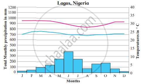
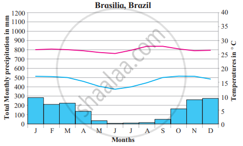
Read the graphs figure a and b and answer the following questions. Locate the places on the map:
- In which months is there no rainfall?
- In which month is the temperature highest?
- In which month is the temperature lowest?
- Are the months of rainfall the same in both places? If not, why?
- What could be the factors which influence the climate of these places?
- What difference do you find between the previous and these graphs?
- Write a concluding statement about the climate of both places.
टिप्पणी लिखिए
उत्तर
- It rains throughout the year in both Lagos and Brasilia.
- Temperature is highest in the month of March in Lagos and in the month of September in Brasilia.
- The temperature is lowest in Lagos in the month of August and that in the month of June in Brasilia.
- It is wettest in June in Lagos and January is the wettest month in Brasilia. Lagos is situated near the equator. Thus, there is a significant precipitation difference between the rainy season and the summer season.
Brasilia is located at the top of the Brazilian highlands. It has a milder climate due to elevation and with two distinct seasons, the rainy season and dry season. - Lagos being near the equator and Brasilia located on the Brasilia highland influences the climate of these places.
- The total monthly precipitation is light in Mangaluru in the month of June, July, August, and that of Cairns in the month of January, February, March whereas in the equatorial region precipitation is experienced throughout the year. From this graph of monsoon climate, we find that maximum precipitation is during the months of June to September.
- The rainfall is much more in summer than in the winter in Lagos. The least amount of rainfall occurs in December while a greater amount of precipitation occurs in June. The temperature is higher on average in March, whereas the lowest LemperaLure occurs in August. Wit,h regards to Brasilia here too the rainfall is much more in summer than the winters. Precipitation is the lowest in June and the highest in January, September is the hottest month and the lowest temperature is in June.
shaalaa.com
Low-latitude Regions - Tropical Savannah Type of Climate
क्या इस प्रश्न या उत्तर में कोई त्रुटि है?
APPEARS IN
संबंधित प्रश्न
- Which agricultural crops are produced Savannah region?
- Why are longitudes not given in geographical distribution?
Give a geographical reason:
The Savannah region is prone to droughts.
On a world map, show the following areas:
- Savannah climatic region in Africa
- Highland climatic region in India
- Chile and Russia
- Icecap climatic region
- Desert climatic region
Answer in detail:
Russia is larger than Chile in the area but does not experience climatic diversity as Chile. Explain.


