Advertisements
Advertisements
प्रश्न
Answer the following question in detail.
Explain the traditional methods of rainwater harvesting in Rajasthan.
उत्तर
The Traditional sources of water in Rajasthan include Nadi, tanka, Bandha, Sagar, Samund, and Sarovar.
The large public wells Known as kohar, Baori, Saagar were owned by the community.
1. Lakes/Talaab: In Rajasthan traditionally, a maximum conversation of water is in the form of lakes. A reservoir area of less than five bighas is called a talai; a medium-sized lake is called a bandhi or talab; a bigger lake is called Sagar or samand.
2. Bawari: In Rajasthan, step-wells are locally known as Bawari and jhalara. These are sweet water aquifers getting a regular recharge through rainwater.
3. Naadi and Pokhara: One of the oldest and still prevalent storage for rainwater harvesting is naadi or dug-out village pond or tank (Pokhara). Naadi construction is more prevalent in western Rajasthan.
4. Tanka: The tanka is circular or rectangular shape pond with a life span of 3-4 years, normally on bare ground to which surface runoff can be diverted. The area around it is a clean catchment.
5. Khadeen: It was first developed in the 15th century in the Jaisalmer district, Khadeen is a most multi-purpose method of water conservation. In the immediate vicinity downstream the sub-surface water is extracted through bore wells.
APPEARS IN
संबंधित प्रश्न
State whether the following statement is true or false and correct the
false statement:
Huge anacondas are found in the swampy areas of Caatinga.
Match the items in Column ‘A’ with those in the Column ‘B’ :
| Column ‘A’ | Column ‘B’ | ||
| 1. | Ujjain | a. | Centre of Urdu language in the Deccan. |
| 2. | Amritsar | b. | Ancient cultural capital of Malwa region. |
| 3 | Hyderabad | c. | Hill Station |
| d. | The holiest of Sikh Shrines. |
Give the geographical reason for the following:
Punjab region is affected by salinity.
Complete the following statement by choosing the appropriate alternatives from those given brackets:
The wool of ________________ breed of sheep is considered of superior quality.
Give geographical reasons for the following statement.
Punjab-Haryana plain has become a granary of India.
Answer the following question in detail.
Why has the wool industry developed in Rajasthan?
Choose the correct option from the following statement:
The Tarai is _________ land.
Answer the following question in detail :
Write an account on dairy farming in Punjab-Haryana Plain.
Match the Column ‘A’ with Column ‘B'
| Column ‘A’ | Column ‘B’ | ||
| 1. | Goat | a. | Step Wells |
| 2. | Bavadis | b. | The holiest of the Sikh shrines. |
| 3. | Harmindir Sahib | c. | Lohi |
| d. | Small tank |
Give the geographical reason for the following:
Laterite Soil are formed in regions receiving heavy rainfall.
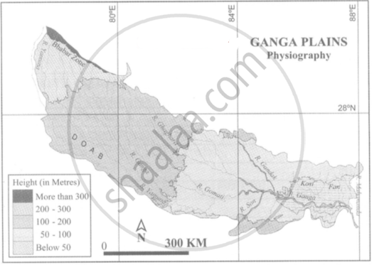
Observe the following figure and answer the following questions given below it.

(4) On which side does the Ganga plain slope down.
What are the important geomorphological features found in the river valley plains?
The ______ plateau lies at the eastern foothills of Aravallis.
