Topics
Field Visit
Location and Extent
Physiography and Drainage
- Physical Divisions of India
- The North Indian Mountains
- The Himalayas
- North Indian Plains
- The Peninsular Indian Plateau
- The Indian Coastal Plains
- The Indian Islands
- Physiography of Brazil
- Brazilian Highlands
- The Great Escarpment in Brazil
- Coastline of Brazil
- Brazilian Plains
- Brazilian Island
- Drainage of Brazil
- Drainage Systems of India
- Himalayan Rivers
- Peninsular Rivers
Climate
Natural Vegetation and Wildlife
Population
Human Settlements
Economy and Occupations
Tourism, Transport and Communication
Geography - Physical Divisions of India
Identification of Physical divisions
- Identification of Physical Divisions
Geography - North Indian Mountains
Himalayas
Associated mountains
- Concept of Associated Mountains
Geography - North Indian Plain Region
Deserts
- Desert
Western Plains
- Concept of Western Plains
Central Plains
- Concept on Central Plains
Delta region
- Concept of Delta Region
Eastern Plains
- Concept of Eastern Plains
Geography - Peninsular Plateau Region
Chhotta Nagpur Plateau
- Concept for Chhotta Nagpur Plateau
Malwa Plateau
- Concept on Malwa Plateau
Maharashtra Plateau
- Concept for Maharashtra Plateau
Karnataka Plateau
- Concept for Karnataka Plateau
Telangana Plateau
- Concept for Telangana Plateau
Geography - Western Ghats and Eastern Ghats
Eastern Ghats
- Concept on Eastern Ghats
Sahyadries
- Concept on Sahyadries
Geography - Coastal Region
- Geography - Coastal Region
Eastern coastal plain
- Coastal Region - Eastern Coastal Plain
- Concept for Western Coastal Plain
Western coastal plain
- Concept for Western Coastal Plain
Geography - Indian Islands
- Geography - Indian Islands
Eastern Islands
- Indian Islands - Eastern Islands
Western Islands
- Indian Islands - Western Islands
Geography - Practical 1
Cartography
- Concept on Cartography
Geography - Practical 2
Two dimensional diagrams
- Two Dimensional Shapes
One dimensional diagrams
- Concept on One Dimensional Diagrams
Economics - Introduction of an Economy
Introduction of an Economy
- Economy
- Types of Economy
- Main Features of Economy
Economics - Basic problems of an economy solution
Solutions
- Concept for Capitalism
- Concept for Socialism
- Mixed Economy
Problems
- Introduction of Basic Problems of an Economy
- Problems- for Whom to Produce
- Problem - How Much to Produce
- Problem - by Whom to Produce
Economics - Inflation
Introduction
- Introduction of Inflation
Effects of inflation
- Effects of Inflation
Measures of Inflation
- Measures of Inflation
Causes of inflation
- Causes of Inflation
Economics - Public distribution system and consumer protection
- Measures of Inflation
Public Distribution system - meaning and explanation
- Public Distribution System - Meaning and Explanation
Introduction
- Introduction of Public Distribution System and Consumer Protection
Objectives of Public Distribution system
- Objectives of Public Distribution System
Remedial Measures
- Remedial Measures Public Distribution System and Consumer Protection
Consumer Protection
- Consumer Protection - Rights and Duties of Cunsumer, Food Adulteration
Drawbacks of Public Distribution system
- Drawbacks of Public Distribution System
Progress of Public Distribution system
- Progress of Public Distribution System
- Ganga Plains
- Brahmaputra Plains
- Rajastan Plains
- Punjab Plains
Definition
- Plains: A plain is a broad area of relatively flat land.
- Doab: Doab is a tract of land between two rivers.
Notes
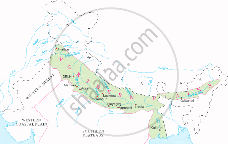
The Great Northern Plains:
- The northern plain has been formed by the interplay of three major river systems, namely the Indus, Ganga, and Brahmaputra, as well as their tributaries.
- It is mostly flat and low lying area.
- They cover one-fifth of the area but house half of South Asia's population. These plains are the focal point of its political, economic, and cultural activities.
- The plain is between 240 to 320 kilometres wide and 2,400 kilometres long. From east to west, it widens. Its area is more than 7 lakh square kilometres.
- This plain is formed of alluvial soil. This fertile plain was formed over millions of years by the deposition of alluvium in a vast basin at the foothills of the Himalaya.
- It is an agriculturally productive part of India due to its rich soil cover, adequate water supply, and favourable climate.
- The Northern Plains of India are divided into four major regions based on sediment deposition by various rivers and topographical features:
1) Ganga Plains
2) Brahmaputra Plains
3) Rajastan Plains
4) Punjab Plains
|
Northern Plains |
1. Rajasthan Plains:
- The Thar desert is divided into two main regions. The Actual Desert Region (Marusthali) and the Semi-Desert Region are the names of these areas (Bhangar).
- Rajasthan Plains is situated west of the Aravalli range.
- It has an area of approximately 1,75,000 square kilometers.
- The river Luni and the long vanished river Saraswati have deposited sediment that has created the Rajasthan plain.
- Rajasthan is home to various salt lakes. Near Jaipur, the most notable lake is Pushkar Lake, also known as Sambhar Salt Lake.
- The Thar desert, often referred to as the Great Indian desert, is a large arid region in the northwest of the Indian subcontinent.
- It has a total area of 2,00,000 km2, and it serves as a natural border between Pakistan and India. It is the 7th largest desert on earth.
- The desert occupies `2/3` of Rajastan state and is located in the western portion of the Aravalli range.
2. Punjab - Haryana Plains:
- The Western part of the Northern Plain is referred to as the Punjab Plains.
- These plains are located in Punjab, Haryana, and Himachal Pradesh in India.
- About 1.75 lakh square kilometres are covered by this plain.
- The majority of this plain is in Pakistan, formed by the Indus and its tributaries including the Jhelum, Chenab, Ravi, Beas, and Satluj.
- The plains are sloping in a westward direction.
- The plain serves as a water - divide (doab). It separates two major watersheds: the Yamuna - Sutlej and Ganga - Yamuna.
- The doabs of the lndus' five tributaries − Jhelum, Chenab, Ravi, Sutlej, and Beas − are a notable feature of these plains. In fact, the name Punjab is derived from these, i.e., the land of five rivers.
- Agriculture is widely practiced in this area due to the rich soil conditions.
3. Ganga Plains:
- It extends from Bangladesh in the east to the Yamuna River in the west.
- Approximately 3.75 sq.km. make up this plain. It covers the states of Uttarakhand, Uttar Pradesh, Bihar, Haryana, Delhi, and a portion of Jharkhand and West Bengal.
- This enormous plain in India was formed by the sediments of the Ganga and its tributaries, including the Ghaghra, Gandak, Kosi, Yamuna, Chambal, Betwa, and others.
- It is the largest plain in India.
- The upper, middle, and lower Ganga plains all have an east to south-east slope.
4. Brahmaputra Plains:
- The Brahmaputra plain is located in the east, specifically in Assam.
- It is formed by the deposits of river Brahmaputra.
- It has a land area of approximately 56,275 sq.km.
- These plains give rise to alluvial fans and marshy areas.
- There are also a number of riverine islands, including Majuli, the world's largest river island.
- The majority of the West Bengal State in both India and Bangladesh makes up the Ganga-Brahmaputra delta. It's called the Sundarbans. It is regarded as the biggest delta in the entire world.
If you would like to contribute notes or other learning material, please submit them using the button below.
Related QuestionsVIEW ALL [17]
Match the Column ‘A’ with Column ‘B'
| Column ‘A’ | Column ‘B’ | ||
| 1. | Goat | a. | Step Wells |
| 2. | Bavadis | b. | The holiest of the Sikh shrines. |
| 3. | Harmindir Sahib | c. | Lohi |
| d. | Small tank |
