Topics
India and the Contemporary World - 1
The French Revolution
- Introduction of the French Revolution
- French Society During the Late Eighteenth Century
- The Outbreak of the Revolution
- France Abolishes Monarchy and Becomes a Republic
- Did Women Have a Revolution
- The Abolition of Slavery
- The Revolution and Everyday Life
Socialism in Europe and the Russian Revolution
- The Age of Social Change
- The Russian Revolution
- The February Revolution in Petrograd
- What Changed After October?
- The Global Influence of the Russian Revolution and the USSR
Nazism and the Rise of Hitler
- Introduction of Nazism and the Rise of Hitler
- Birth of the Weimar Republic
- Hitler’s Rise to Power
- The Nazi Worldview
- Youth in Nazi Germany
- Ordinary People and the Crimes Against Humanity
Forest Society and Colonialism
- Introduction of Forest Society and Colonialism
- Deforestation and Its Causes
- The Rise of Commercial Forestry
- Rebellion in the Forest
- Forest Transformations in Java
Pastoralists in the Modern World
- Introduction of Pastoralists in the Modern World
- Pastoral Nomads and Their Movements
- Colonial Rule and Pastoral Life
- Pastoralism in Africa
Contemporary India - 1
India - Size and Location
Physical Features of India
Drainage
- Drainage
- Drainage Systems of India
- Himalayan Rivers
- Characteristics of Himalayan Rivers
- Peninsular Rivers
- Characteristics of Peninsular Rivers
- Lakes
- Role of Rivers in the Economy
- River Pollution
Climate
- Climate
- Climate of India
- Climatic Controls
- Factors Affecting the Indian Climate
- The Indian Monsoon
- The Onset of the Monsoon and Withdrawal
- Seasons of India
- The Winter Season or Cold Weather
- The Summer or Hot Weather Season
- Southwest Monsoon or Rainy Season
- Northeast monsoon season or Retreating Monsoon
- Distribution of Rainfall
- Monsoon as a Unifying Bond
Natural Vegetation and Wildlife
Population
Democratic Politics - 1
What is Democracy? Why Democracy?
- What is Democracy?
- Features of Democracy
- Why Democracy
- Broader Meanings of Democracy
Constitutional Design
- Democratic Constitution in South Africa
- Why Do We Need a Constitution?
- Making of the Indian Constitution
- Guiding Values of the Indian Constitution
Electoral Politics
- Why Elections?
- What is Our System of Elections?
- What Makes Elections in India Democratic?
Working of Institutions
- How is a Major Policy Decision Taken
- Parliament
- Political Executive
- The Judiciary
Democratic Rights
- Life Without Rights
- Rights in a Democracy
- Rights in the Indian Constitution
- Expanding Scope of Rights
Economics
The Story of Village Palampur
- Introduction of the Story of Village Palampur
- Organisation of Production
- Farming in Palampur
- Non-farm Activities in Palampur
People as Resource
- Introduction of People as Resource
- Economic Activities by Men and Women
- Quality of Population
- Unemployment
Poverty as a Challenge
- Introduction of Poverty as a Challenge
- Two Typical Cases of Poverty
- Poverty as Seen by Social Scientists
- Poverty Estimates
- Vulnerable Groups
- Inter-state Disparities
- Global Poverty Scenario
- Causes of Poverty
- Anti-poverty Measures
- The Challenges Ahead of Poverty
Food Security in India
- Food Security
- Food Insecure
- Food Security in India
- Buffer Stock
- Public Distribution System
- Current Status of the Public Distribution System
- Role of Cooperatives in Food Security
Disaster Management
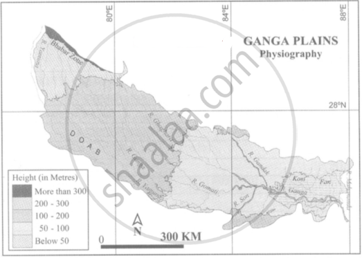
- Ganga Plains
- Brahmaputra Plains
- Rajastan Plains
- Punjab Plains
Definition
- Plains: A plain is a broad area of relatively flat land.
- Doab: Doab is a tract of land between two rivers.
Notes
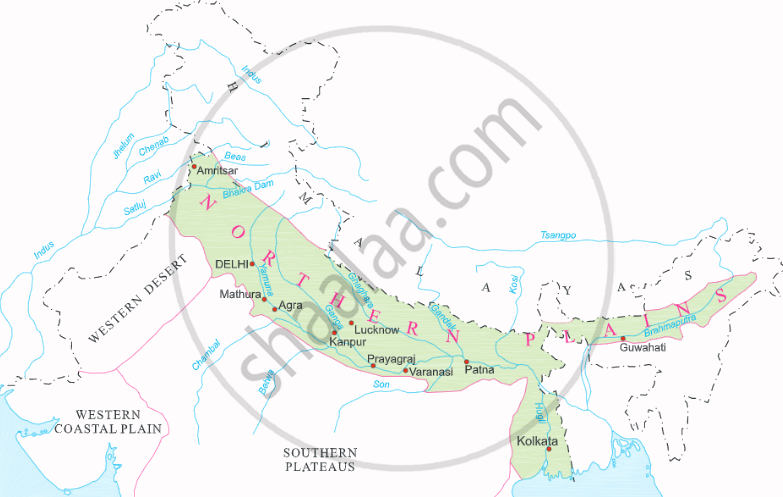
The Great Northern Plains:
- The northern plain has been formed by the interplay of three major river systems, namely the Indus, Ganga, and Brahmaputra, as well as their tributaries.
- It is mostly flat and low lying area.
- They cover one-fifth of the area but house half of South Asia's population. These plains are the focal point of its political, economic, and cultural activities.
- The plain is between 240 to 320 kilometres wide and 2,400 kilometres long. From east to west, it widens. Its area is more than 7 lakh square kilometres.
- This plain is formed of alluvial soil. This fertile plain was formed over millions of years by the deposition of alluvium in a vast basin at the foothills of the Himalaya.
- It is an agriculturally productive part of India due to its rich soil cover, adequate water supply, and favourable climate.
- The Northern Plains of India are divided into four major regions based on sediment deposition by various rivers and topographical features:
1) Ganga Plains
2) Brahmaputra Plains
3) Rajastan Plains
4) Punjab Plains
|
Northern Plains |
1. Rajasthan Plains:
- The Thar desert is divided into two main regions. The Actual Desert Region (Marusthali) and the Semi-Desert Region are the names of these areas (Bhangar).
- Rajasthan Plains is situated west of the Aravalli range.
- It has an area of approximately 1,75,000 square kilometers.
- The river Luni and the long vanished river Saraswati have deposited sediment that has created the Rajasthan plain.
- Rajasthan is home to various salt lakes. Near Jaipur, the most notable lake is Pushkar Lake, also known as Sambhar Salt Lake.
- The Thar desert, often referred to as the Great Indian desert, is a large arid region in the northwest of the Indian subcontinent.
- It has a total area of 2,00,000 km2, and it serves as a natural border between Pakistan and India. It is the 7th largest desert on earth.
- The desert occupies
2. Punjab - Haryana Plains:
- The Western part of the Northern Plain is referred to as the Punjab Plains.
- These plains are located in Punjab, Haryana, and Himachal Pradesh in India.
- About 1.75 lakh square kilometres are covered by this plain.
- The majority of this plain is in Pakistan, formed by the Indus and its tributaries including the Jhelum, Chenab, Ravi, Beas, and Satluj.
- The plains are sloping in a westward direction.
- The plain serves as a water - divide (doab). It separates two major watersheds: the Yamuna - Sutlej and Ganga - Yamuna.
- The doabs of the lndus' five tributaries − Jhelum, Chenab, Ravi, Sutlej, and Beas − are a notable feature of these plains. In fact, the name Punjab is derived from these, i.e., the land of five rivers.
- Agriculture is widely practiced in this area due to the rich soil conditions.
3. Ganga Plains:
- It extends from Bangladesh in the east to the Yamuna River in the west.
- Approximately 3.75 sq.km. make up this plain. It covers the states of Uttarakhand, Uttar Pradesh, Bihar, Haryana, Delhi, and a portion of Jharkhand and West Bengal.
- This enormous plain in India was formed by the sediments of the Ganga and its tributaries, including the Ghaghra, Gandak, Kosi, Yamuna, Chambal, Betwa, and others.
- It is the largest plain in India.
- The upper, middle, and lower Ganga plains all have an east to south-east slope.
4. Brahmaputra Plains:
- The Brahmaputra plain is located in the east, specifically in Assam.
- It is formed by the deposits of river Brahmaputra.
- It has a land area of approximately 56,275 sq.km.
- These plains give rise to alluvial fans and marshy areas.
- There are also a number of riverine islands, including Majuli, the world's largest river island.
- The majority of the West Bengal State in both India and Bangladesh makes up the Ganga-Brahmaputra delta. It's called the Sundarbans. It is regarded as the biggest delta in the entire world.
If you would like to contribute notes or other learning material, please submit them using the button below.