Advertisements
Advertisements
प्रश्न
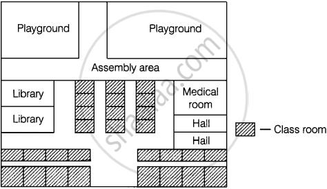
Draw a map of your school playground. Mark all necessary places like 2 library, Playground, Medical Room, Classrooms, Assembly area, etc.
उत्तर
A number of maps can be drawn for a school from which one map is given below:
APPEARS IN
संबंधित प्रश्न
All the classrooms in Ashi s school look like this. Look carefully and answer.

- Can a child sitting in III-A see the playground?
If 4 km on a map is represented by 1 cm, then 16 km is represented by ______ cm.
If actual distance between two places A and B is 110 km and it is represented on a map by 25 mm. Then the scale used is ______.
If a length of 100 m is represented on a map by 1 cm, then the actual distance corresponding to 2 cm is 200 m.
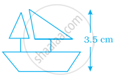
The model of a ship shown is of height 3.5 cm. The actual height of the ship is 210 cm if the scale chosen is 1 : 60.
A photographer uses a computer program to enlarge a photograph. What is the scale according to which the width has enlarged?
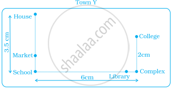
Use a ruler to measure the distance in cm between the places joined by dotted lines. If the map has been drawn using the scale 1 cm : 10 km, find the actual distances between school and library.

Use a ruler to measure the distance in cm between the places joined by dotted lines. If the map has been drawn using the scale 1 cm : 10 km, find the actual distances between college and complex.
Look at the map given below![]() Houses
Houses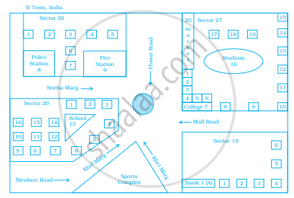
Now, answer the following questions.
Which sector has maximum number of houses?
Look at the map given below![]() Houses
Houses
Now, answer the following questions.
In which sector is Fire Station located?
