Advertisements
Advertisements
प्रश्न
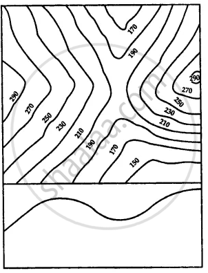
How would you identify the following on a topo sheet: Pass
उत्तर
Passes are low valleys or opening lying between two peaks in a range of hills. A pass is indicated by a drop in height of contours.
APPEARS IN
संबंधित प्रश्न
Draw a diagram to show a cliff.
Draw a diagram to show a waterfall?
How can V-shaped valleys and U-shaped valleys be identified on a topo sheet?
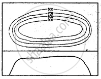
Identify the relief features shown by the following contour diagram
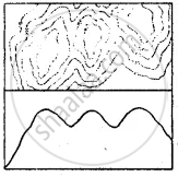
Identify the relief features shown by the following contour diagram
How would you identify the following on a topo sheet: Gentle slope and steep slope
How would you identify the following on a topo sheet: Plateau
Mention what does the following indicate on a topographical map: Blue stream
Mention what does the following indicate on a topographical map: Yellow area
Fill in the blanks
If contour lines are drawn close together, it indicates ______ slope of the land and if they are drawn far apart, it indicates ______ slope.
