ISC (Arts)
Academic Year: 2023-2024
Date & Time: 16th February 2024, 2:00 pm
Duration: 3h
Advertisements
- Candidates are allowed additional 15 minutes for only reading the paper.
- They must NOT start writing during this time.
- Answer all questions in Section A, Section B and Section C.
- Section A consists of objective/very short answer questions.
- Section B consists of short answer questions.
- Section C consists of long answer questions.
- The intended marks for questions or parts of questions are given in brackets [].
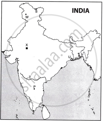
- On the given outline map of India, mark and label the following:
- The highest range of the Himalayas.
- The northern part of the western coastal plains of India.
- The water body that lies between the peninsulas of Kachchh and Kathiawar.
- Refer to the given outline Map of India and label the following:
- The Nuclear Power Plant marked X is ______.
- The river marked T is ______.
- The state with the highest density of roads marked Y is ______.
Chapter: [0.07] Map Work
Refer to the outline map of India. Identify the correct option from the ones given below and write it in the answer.

- The mountain pass located at the Indo-China border marked S is ______.
- Nathu La
- Shipki La
- Karakoram
- Bomdi La
- The port marked U which mainly exports tea, is ______.
- Visakhapatnam
- Kolkata
- Kandla
- Mumbai
- The city market P, known as Information Technology Capital of India, is ______.
- Bengaluru
- Chennai
- Ahmedabad
- Mumbai
- The terminal towns of the North-South corridor marked Wand Z are ______.
- Porbandar and Silchar
- Porbandar and Kanyakumari
- Srinagar and Kanyakumari
- Srinagar and Silchar
Chapter: [0.07] Map Work
The city of Delhi has spread and coalesced with surrounding neighbouring towns like Gurugram and Noida. What is this known as:
Ribbon settlement
Metropolis
Urban Agglomeration
Urban Sprawl
Chapter: [0.027000000000000003] Urban settlements
Assertion: The Himalayas were formed due to the collision of tectonic plates.
Reason: Indian plate moved northwards and pushed beneath the Eurasian Plate leading to the compression of sediments in the Tethys Sea.
Both Assertion and Reason are true, and Reason is the correct explanation for Assertion.
Both Assertion and Reason are true, but Reason is not the correct explanation for Assertion.
Assertion is true and Reason is false.
Assertion is false and Reason is true.
Chapter: [0.012] Structure of India
The land left uncultivated for a period of one to five years to help soil regain its fertility is called ______.
Chapter: [0.032] Land Resources
Give a reason for the following:
Industries are unevenly located in India.
Chapter: [0.042] Communication – Importance of Communication in Rural Development and Its Policy. Importance of Infrastructure as Key to the Development of an Industrial Economy.
Intensive fishing is practised along the coast of Andhra Pradesh. Give any two reasons to justify this statement.
Chapter: [0.035] Fishing in India, Japan and Bangladesh.
How have Korba and Bailadila contributed to making Chhattisgarh an important mining region of India?
Chapter: [0.06] Regional Economic Development
A landowner bought cultivable land for growing a crop. Despite all his efforts the land did not yield any crop.
Give any two reasons to explain why the land did not yield any crop.
Chapter: [0.032] Land Resources
State any two reasons why fragmentation of land holdings leads to low agricultural productivity in India.
Chapter: [0.032] Land Resources
Advertisements
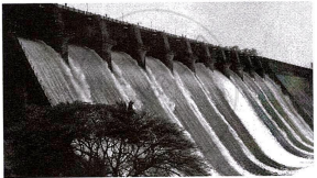
State any two conditions that are favourable for generation of power from the energy source shown above.
Chapter: [0.036000000000000004] Sources of Energy
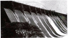
Briefly discuss the significance of this energy source in ensuring sustainable development.
Chapter: [0.036000000000000004] Sources of Energy
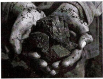
The image given above shows a fossil fuel that has versatile uses. Mention any two of its uses.
Chapter: [0.036000000000000004] Sources of Energy
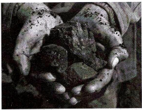
State any two disadvantages of above fossil fuel.
Chapter: [0.036000000000000004] Sources of Energy
Which two modern methods of irrigation are well suited for regions with low ground water resources?
Chapter: [0.033] Water Resources and Types of Irrigation
State any two advantages of these modern methods of irrigation.
Chapter: [0.033] Water Resources and Types of Irrigation
Study the sketch map given below and answer the questions that follow.

- Name the National Highways Development Project which connects the four cities marked on the map.
- Give any three reasons to justify that such transport projects strengthen the industrial economy of India.
Chapter: [0.07] Map Work
How has Indian agriculture transformed from subsistence to commercial farming?
Chapter: [0.034] Agriculture: Types, Development and Problems
State any two conditions that favour the cultivation of cotton in India.
Chapter: [0.053] Location, production and growth of the following industries
Briefly explain any two strategies of the Second Green Revolution in India.
Chapter: [0.034] Agriculture: Types, Development and Problems
State any two climatic conditions required for cultivation of coconut in India.
Chapter: [0.032] Land Resources
Advertisements
India is referred to as a sub-continent. Justify.
Chapter: [0.012] Structure of India
How is the Himalayan River system different from the Peninsular River system?
Chapter: [0.012] Structure of India
Study the temperature and rainfall graphs of Station X and Y and answer the questions that follow:
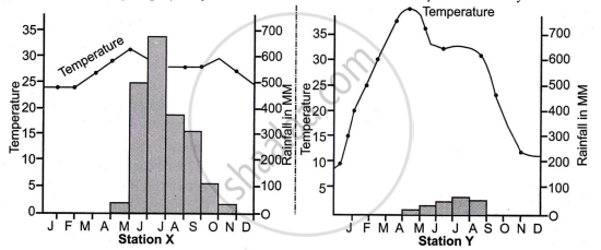
- Which station has a coastal location? Why?
- What is the source of rainfall in Station X?
- Why does Station Y receive scanty rainfall?
Chapter: [0.013000000000000001] Climate: India
What is urban forestry?
Chapter: [0.013999999999999999] Natural Vegetation
Mention any two objectives of Urban Forestry.
Chapter: [0.013999999999999999] Natural Vegetation
Analyse the sketch map given below which shows two flood prone regions of India marked P and S.
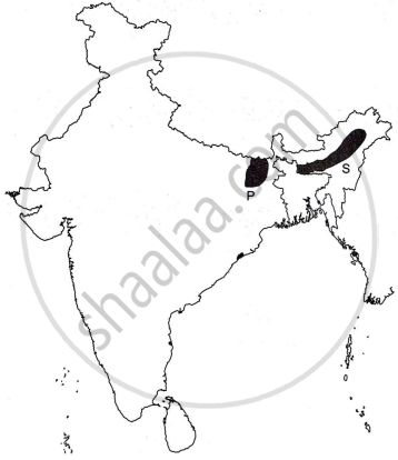
Explain any four causes of floods in these regions.
Chapter: [0.07] Map Work
How do you think agro-forestry is beneficial besides reducing greenhouse emissions?
Chapter: [0.013999999999999999] Natural Vegetation
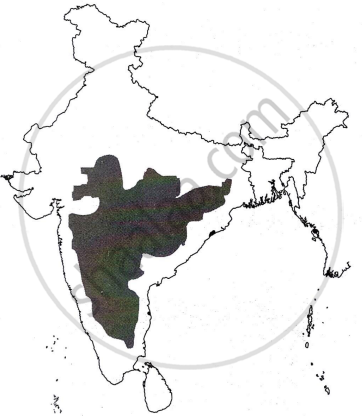
Identify the shaded part in the map given above. State any two characteristic features of this relief division. What is its significance?
Chapter: [0.07] Map Work
Give any three differences between Eastern Ghats and Western Ghats.
Chapter: [0.07] Map Work
| The flow of migrants to urban cities has been increasing. This rapid increase in the urban population has exerted immense pressure on the available resources in the urban centres. |
Discuss any four problems triggered by the increase of migrants in the area referred to above.
Chapter: [0.027000000000000003] Urban settlements
| The flow of migrants to urban cities has been increasing. This rapid increase in the urban population has exerted immense pressure on the available resources in the urban centres. |
State any three factors that determine the movement of migrants in the area referred to above.
Chapter: [0.027000000000000003] Urban settlements
Read the passage given below and answer the questions that follow:
|
The police station in Alipore, Kolkata has installed ten solar panels and minimised the consumption of thermal electricity. These solar panels keep all lights, fans, computers and other basic electrical equipment running throughout the day at the police station. According to the officials, Alipore police station had an average monthly bill of around 1.10 lakhs during summer. This prompted the officials to think out of the box and use other sources of energy. |
- Which type of energy did the officials at Alipore police station decide to use?
- State the two conditions required for the generation of this type of energy.
- Discuss four advantages of this type of energy.
Chapter: [0.036000000000000004] Sources of Energy
Submit Question Paper
Help us maintain new question papers on Shaalaa.com, so we can continue to help studentsonly jpg, png and pdf files
CISCE previous year question papers Class 12 Geography with solutions 2023 - 2024
Previous year Question paper for CISCE Class 12 -2024 is solved by experts. Solved question papers gives you the chance to check yourself after your mock test.
By referring the question paper Solutions for Geography, you can scale your preparation level and work on your weak areas. It will also help the candidates in developing the time-management skills. Practice makes perfect, and there is no better way to practice than to attempt previous year question paper solutions of CISCE Class 12.
How CISCE Class 12 Question Paper solutions Help Students ?
• Question paper solutions for Geography will helps students to prepare for exam.
• Question paper with answer will boost students confidence in exam time and also give you an idea About the important questions and topics to be prepared for the board exam.
• For finding solution of question papers no need to refer so multiple sources like textbook or guides.
