Advertisements
Advertisements
Question
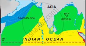
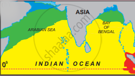
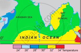
Study maps given in the figure carefully. These maps are showing the portion of the Indian Ocean lying north of the equator. Maps in the figure depict the temperature conditions in three seasons:
- pre-SW monsoon,
- NE monsoon
- during SW monsoon.
Answer the following questions.
- Why are isotherms not drawn on the continental part?
- Why is the temperature in the Arabian Sea lower than in the Bay of Bengal?
- Why is the temperature higher in the southern portion of the Indian Ocean during pre SW monsoon?
Short Note
Solution
- The isotherms are not drawn on the continental part because there is summer season and the temperature is high almost everywhere. Since there is no variation in temperature, isotherms are not drawn.
- The temperature is low in the Arabian Sea than in the Bay of Bengal due to the following reasons -
(i) The salinity of the Arabian Sea is high so it lowers the temperature but the salinity of the Bay of Bengal is low.
(ii) The Arabian Sea is an open and broad sea compared to the Bay of Bengal which is narrow and enclosed by landmasses. There is a lot of movement of ocean water in the Arabian Sea as compared to the Bay of Bengal. - The southern portion of the Indian Ocean is closer to the equator compared to the northern portion of the Arabian Sea. During the pre-SW monsoon period, Uttarayan has observed therefore the temperature is high.
shaalaa.com
Islands of Indian Ocean
Is there an error in this question or solution?
