(English Medium)
Academic Year: 2016-2017
Date & Time: 20th March 2017, 11:00 am
Duration: 2h
Advertisements
Question 1 and Question 2 is compulsory.
Attempt any five questions from Question 3 to Questions 11
On an outline map of India provided:
(a) Draw and name the Tropic of Cancer.
(b) Label the river Godavari.
(c) Mark and name the Garo Hills.
(d) Mark C on the coal fields of Jharia.
(e) Mark with an arrow and name the NE monsoon over the Bay of Bengal.
(f) Shade and name the Gulf of Kutch.
(g) Shade and name the coastal plain that receives rainfall in October and November.
(h) Mark with a dot and name Delhi.
(i) Shade a region with Black Cotton Soil.
(j) Use an arrow to point at a densely populated state in South India.
Chapter: [0.05] Map of India
Mention the four seasons that prevail in India stating the months for each
Chapter: [0.07] Climate
State the agricultural benefits derived from: The Westerly Depressions in Punjab
Chapter: [0.14] Agriculture - I
State the agricultural benefits derived from: The Kalbaisakhi in Assam
Chapter: [0.14] Agriculture - I
Give a reason for each of the following:
Kolkata receives heavier rain than Lucknow.
Chapter: [0.07] Climate
Give a reason for each of the following:
The Summer Monsoon winds blow over the Arabian Sea from the South West.
Chapter: [0.07] Climate
Give a reason for each of the following:
Thar is a desert
Chapter: [0.07] Climate
Study the climatic data given below and answer the questions that follow:
| Month | Jan | Feb | Mar | Apr | May | June | July | Aug | Sep | Oct | Nov | Dec |
| Temperature in °C |
12.0 | 25.5 | 26.3 | 27.1 | 30.0 | 36.2 | 36.0 | 35.9 | 30.3 | 28.4 | 21.0 | 16.6 |
| Rainfall cm | 1.5 | 0.1 | 0.0 | 1.4 | 1.1 | 21.0 | 25.3 | 27.2 | 24.0 | 9.4 | 1.5 | 0.4 |
1) What is the annual range of temperature of the station?
2) What is the total annual rainfall experienced by the station?
3) Why would it be correct to presume that the station lies in the interior and not on the coast?
Chapter: [0.07] Climate
Mention two differences between Alluvial Soil and Black Cotton Soil.
Chapter: [0.08] Soil Resources
Name an area in India in which each of the following processes takes place.
Sheet erosion
Chapter: [0.08] Soil Resources
Name an area in India in which each of the following processes takes place
Gully erosion
Chapter: [0.08] Soil Resources
What is soil conservation?
Chapter: [0.08] Soil Resources
State a method of soil conservation in the Arid and Semi-Arid region
Chapter: [0.08] Soil Resources
State a method of soil conservation in the River valleys prone to floods
Chapter: [0.08] Soil Resources
Name the soil which is good for cultivation of sugarcane.
Chapter: [0.08] Soil Resources
Name the soil which is acidic in nature.
Chapter: [0.08] Soil Resources
Name the soil which occurs ex situ
Chapter: [0.08] Soil Resources
How do trees in the Tropical desert forests adapt themselves to the dry climate?
Chapter: [0.07] Climate
Name the tree as per the characteristics are given below
The wood is hard and suitable for shipbuilding
Chapter: [0.09] Natural Vegetation
Name the tree as per the characteristics are given below
The stilt roots are underwater during high tide.
Chapter: [0.09] Natural Vegetation
Advertisements
Explain why the forest cover in India is shrinking?
Chapter: [0.09] Natural Vegetation
Name the natural vegetation found in the following regions:
The western slopes of the Western Ghats
Chapter: [0.09] Natural Vegetation
Name the natural vegetation found in the following regions:
The Nilgiris
Chapter: [0.09] Natural Vegetation
Name the natural vegetation found in the following regions:
Western Rajasthan
Chapter: [0.09] Natural Vegetation
Give a reason for the significance of irrigation in Punjab
Chapter: [0.1] Water Resources
Give a reason for the significance of irrigation in Rajasthan
Chapter: [0.1] Water Resources
Name a state where Tube wells are common.
Chapter: [0.1] Water Resources
Name a state where Tank irrigation is popular
Chapter: [0.1] Water Resources
Give one geographical reason for each of the following:
Sprinkler irrigation is practised in arid and semi-arid regions.
Chapter: [0.1] Water Resources
Give one geographical reason for each of the following:
A tube well should be installed in a fertile and productive region.
Chapter: [0.1] Water Resources
Give one geographical reason for each of the following:
Canal irrigation is more suitable in the Northern Plains.
Chapter: [0.1] Water Resources
Study the diagram below and answer the questions that follow:
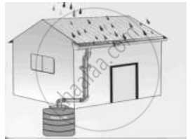
1) Name the activity shown in the diagram.
2) Give two objectives of the activity named in (d) (i).
Chapter:
Give the names of four important iron ores found in India.
Chapter:
Name the following: An offshore oil field in the Gulf of Cambay.
Chapter: [0.01] Interpretation of Topographical Maps
Name the following: An oil refinery in Bihar.
Chapter: [0.01] Interpretation of Topographical Maps
Name the state that produces the largest amount of limestone.
Chapter: [0.01] Interpretation of Topographical Maps
What is mixed farming?
Chapter: [0.15] Agriculture - II: Food Crops
Mention any one benefit of mixed farming.
Chapter: [0.14] Agriculture - I
Give the Geographical requirement for the cultivation of Sugarcane.
Chapter: [0.14] Agriculture - I
Advertisements
Explain the following terms and name the crop with which each one is associated:
Retting
Chapter: [0.15] Agriculture - II: Food Crops
Explain the following terms and name the crop with which each one is associated:
Ratooning
Chapter: [0.15] Agriculture - II: Food Crops
Explain the following terms and name the crop with which each one is associated:
Ginning
Chapter: [0.15] Agriculture - II: Food Crops
Give the geographical reason for the following:
Regular pruning is essential for tea bushes.
Chapter: [0.15] Agriculture - II: Food Crops
Give the geographical reason for the following:
Coffee beans are roasted.
Chapter: [0.15] Agriculture - II: Food Crops
Give the geographical reason for the following:
Millets are known as dry crops.
Chapter: [0.15] Agriculture - II: Food Crops
Differentiate between mineral based industry and agro-based industry giving one example for each.
Chapter:
Though Uttar Pradesh has the largest number of sugar mills yet Maharashtra is the largest producer of sugar. Give any two reasons to justify the statement.
Chapter: [0.15] Agriculture - II: Food Crops
Give the geographical term for each of the following:
Non- mulberry silk produced in Madhya Pradesh.
Chapter: [0.15] Agriculture - II: Food Crops
Give the geographical term for each of the following:
Rejected cane after crushing.
Chapter: [0.15] Agriculture - II: Food Crops
Give the geographical term for each of the following:
The rearing of silkworms to obtain silk.
Chapter: [0.15] Agriculture - II: Food Crops
With reference to cotton textile industry answer the following:
Give two reasons why Mumbai is an important cotton textile industry.
Chapter:
With reference to cotton textile industry answer the following:
Mention two more important centres of cotton textile industry in India.
Chapter:
The Iron and Steel industry constitutes the backbone of the modern industrial economy’. Give two reasons to justify the statement.
Chapter: [0.19] Mineral Based Industry
Name an iron and steel industry set up in Orissa with the help of a famous German firm.
From where does the industry name get its iron ore and manganese?
Chapter: [0.19] Mineral Based Industry
Name a manufacturing centre for each of the following industries:
Aircraft
Chapter: [0.2] Transport
Name a manufacturing centre for each of the following industries:
HMT
Chapter: [0.2] Transport
Name a manufacturing centre for each of the following industries:
Railway coaches
Chapter: [0.2] Transport
Name two products each of the following:
petrochemical industry
Chapter:
Name two products each of the following:
heavy engineering industry
Chapter:
Name two products each of the following: electronic industry
Chapter:
Mention two reasons why more people use railways rather than airways.
Chapter: [0.2] Transport
Why is inland waterway declining in its importance?
Chapter: [0.2] Transport
What do you mean by the following:
Sewage
Chapter: [0.22] Waste Management - II: Safe Disposal of Waste
What do you mean by the following:
Eutrophication
Chapter: [0.22] Waste Management - II: Safe Disposal of Waste
What do you mean by the following: Recycling
Chapter: [0.22] Waste Management - II: Safe Disposal of Waste
‘Methane is an air pollutant that causes Greenhouse effect’. Name three sources of this gas.
Chapter: [0.21] Waste Management - I: Impact of Waste Accumulation
Other Solutions
Submit Question Paper
Help us maintain new question papers on Shaalaa.com, so we can continue to help studentsonly jpg, png and pdf files
CISCE previous year question papers ICSE Class 10 Geography with solutions 2016 - 2017
Previous year Question paper for CISCE ICSE Class 10 -2017 is solved by experts. Solved question papers gives you the chance to check yourself after your mock test.
By referring the question paper Solutions for Geography, you can scale your preparation level and work on your weak areas. It will also help the candidates in developing the time-management skills. Practice makes perfect, and there is no better way to practice than to attempt previous year question paper solutions of CISCE ICSE Class 10 .
How CISCE ICSE Class 10 Question Paper solutions Help Students ?
• Question paper solutions for Geography will helps students to prepare for exam.
• Question paper with answer will boost students confidence in exam time and also give you an idea About the important questions and topics to be prepared for the board exam.
• For finding solution of question papers no need to refer so multiple sources like textbook or guides.
