HSC Arts (English Medium)
Academic Year: 2024-2025
Date & Time: 7th March 2025, 3:00 pm
Duration: 3h
Advertisements
Note:
- All questions are compulsory.
- Draw relevant diagrams/graphs wherever necessary.
- Use of colour pencil is allowed.
- Use of map stencil is allowed.
- Figures to the right indicate full marks.
- The supplement of map to your main answer sheet.
Complete the chain and rewrite in your answer paper:
| No. | 'A' | 'B' | 'C' |
| (1) | Amazon River basin | (1) Manufacturing Activities | (1) Tata Iron and Steel Industries |
| (2) | Constrictive Pyramid | (2) Commercial cattle rearing | (2) Low population density |
| (3) | Industrial Region | (3) Individual | (3) Low birth rate and least death rate |
| (4) | Pampas Grassland | (4) Dense equatorial Forest | (4) South America |
| (5) | Private | (5) More old age Population | (5) Availability of Employment |
Chapter:
Appalachian mountain region of U.S.A has dense population because.
uneven physical condition
inaccessible mountainous region
development of iron-ore and coal mines
war-like condition
Chapter:
Ideal location for fishing.
rugged coasts, shallow seas, hot climate, growth of planktons
shallow seas, confluence of warm and cold ocean currents, growth of planktons, cold climate
continental shelf, growth of planktons, good fishing skills, cold climate
continental shelf, rugged coasts, growth of planktons, cold climate
Chapter: [0.04] Primary Economic Activities
In USA, industrial areas are found in North-Eastern region.
dense population
availability of capital
availability of rich deposits of coal and iron-ore
centralization of transport route
Chapter:
Choose one subregion in northern plain region of India.
The Nile plain
The Ganga-Yamuna plain
The Mississippi Basin
The Amazon Basin
Chapter:
Major physical factor which affects regional development.
Natural resources
Sex-ratio
School register ratio
Employment
Chapter:
Assertion A: Hardwood trees are found in equatorial evergreen Forest.
Reasoning R: Lumbering is not developed on a commercial level in equatorial regions.
Only A is correct.
Only R is correct.
Both A and R are correct and R is the correct explanation of A.
Both A and R are correct and R is not the correct explanation of A.
Chapter:
Assertion (A): In India, industrial areas are found concentrated in few regions.
Reasoning (R): India is agricultural country.
Only A is correct.
Only R is correct.
Both A and R are correct and R is the correct explanation of A.
Both A and R are correct but R is not the correct explanation of A.
Chapter:
Assertion (A): In tertiary occupation, there is no derivation from the nature.
Reasoning (R): It provides only services so it is known as service sector.
Only A is correct.
Only R is correct.
Both A and R are correct and R is the correct explanation of A.
Both A and R are correct but R is not the correct explanation of A.
Chapter:
Assertion (A): Each formal regions have distinct boundaries which make them easy to identify.
Reasoning (B): Region is bounded by economic activities.
Only A is correct.
Only R is correct.
Both A and R are correct and R is the correct explanation of A.
Both A and R are correct but R is not the correct explanation of A.
Chapter:
Assertion (A): Physical or human factors are not static but highly dynamic. They change over time.
Reasoning (R): The earth is dynamic. We find there are variations in its physical and cultural environments.
Only A is correct.
Only R is correct.
Both A and R are correct and R is the correct explanation of A.
Both A and R are correct but R is not the correct explanation of A.
Chapter:
Identify the incorrect factor and write it:
Densely populated region due to mineral deposits −
Gold mine region of Australian desert.
Mineral oil region of South West Asia.
Mineral producing Chhota Nagpur region of India.
Prairie grassland region in North America
Chapter:
Identify the incorrect factor and write it:
Primary occupations depending upon natural resources –
Agriculture
Hunting
Motor industry
Lumbering
Chapter:
Advertisements
Identify the incorrect factor and write it:
Footloose industries
Cement industries
Clock making industries
Diamond cutting industries
Hairpin making industries
Chapter:
Identify the incorrect factor and write it:
Permanent Human Settlements are not found in Antarctica.
Very cool climate
Fertile soil
Frozen land
Long winter
Chapter:
Identify the incorrect factor and write it:
Factors studied in physical geography
Atmospheric factors
Relief
Lakes
Transport
Chapter:
Give geographical reasons:
Literacy rate of a country is an indicator of its socio-economic development.
Chapter: [0.02] Population : Part - 2
Give geographical reasons:
Agriculture is done on a large scale in India.
Chapter: [0.04] Primary Economic Activities
Give geographical reasons:
Distribution of industries is uneven.
Chapter: [0.05] Secondary Economic Activities
Give geographical reasons:
Industrial development is not found in Central Australia.
Chapter:
Give geographical reasons.
Factors like illiteracy, poverty affect the regional development.
Chapter: [0.07] Region and Regional Development
Give geographical reason:
Geography is dualistic in nature.
Chapter: [0.08] Geography : Nature and Scope
Differentiate between:
Land use and Land cover
Chapter: [0.03] Human Settlements and Land Use
Distinguish between the Public sector and the Private sector.
Chapter:
Differentiate between:
Physical region and political region.
Chapter: [0.07] Region and Regional Development
Differentiate between:
Regional development and Regional imbalance
Chapter:
Differentiate between:
Possibilism and Determinism.
Chapter: [0.08] Geography : Nature and Scope
Advertisements
Mark and name the following on the outline map of the world with suitable index:
- Thinly populated region of South America
- Show an African Country in second phase of demographic transition
- Major administrative city in Maharashtra
- Area of animal husbandry in Australia
- Leading country of Asia in fishing
- Cape of Good Hope waterways
- Nile River basin
- Siberian plateau
Chapter:
Read the following graph and answer the questions given below:
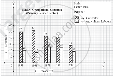
Questions:
- What is shown in the above graph?
- Which decade has maximum percentages of cultivators?
- Which decade has minimum percentages of agricultural labourers?
- In present graph, which factor have maximum percentages in every decade?
- In 1971 what is the percentage of cultivators and agricultural labours?
Chapter:
Write a short note on the correlation between birth rates and death rates.
Chapter: [0.01] Population : Part - 1
Write a short note on:
Mixed land use.
Chapter: [0.03] Human Settlements and Land Use
Write short notes on:
Hunting and loss of ecosystem
Chapter: [0.04] Primary Economic Activities
Short note:
Role of transportation in industries.
Chapter: [0.05] Secondary Economic Activities
Short note:
Importance of satellites as a means of communication.
Chapter: [0.06] Tertiary Economic Activities
Read the following passage and answer the questions given below:
|
Considering the latitudinal distribution of animal husbandry in the world, it is located between 30°N to 60°N and 30°S to 55°S latitudes. Climate is one of the most influencing factors in the development of animal husbandry. It is more developed in the Northern Hemisphere. Presence of grasslands in Australia and North and South America has led to distribution of this occupation. But, this occupation is influenced by advanced technology market and availability of large estates. It has developed on a commercial basis in North America, South America and Australia. The animal husbandry in North and South America is carried out with the help of advanced technology on a commercial scale. Dense forests, inhospitable climate, low quality fodder in equatorial region has discouraged the development of animal husbandry in these regions. |
Questions:
- In which latitude, world distribution of animal husbandry is found?
- Which hemisphere has maximum development of animal husbandry?
- Which factor affects animal husbandry in Australia and South and North America continents?
- Which continents have maximum mechanization of animal husbandry in the world?
Chapter:
Draw neat, labelled diagram:
Stationary pyramids
Chapter: [0.02] Population : Part - 2
Draw neat, labelled diagram:
Circular Settlement
Chapter:
Draw neat, labelled diagram:
Relationship of geography with other subjects.
Chapter: [0.08] Geography : Nature and Scope
Explain the human factors affecting distribution of population.
Chapter: [0.01] Population : Part - 1
Explain the factors affecting trade between two countries.
Chapter: [0.06] Tertiary Economic Activities
Other Solutions
Submit Question Paper
Help us maintain new question papers on Shaalaa.com, so we can continue to help studentsonly jpg, png and pdf files
Maharashtra State Board previous year question papers 12th Standard Board Exam Geography with solutions 2024 - 2025
Previous year Question paper for Maharashtra State Board 12th Standard Board Exam Geography-2025 is solved by experts. Solved question papers gives you the chance to check yourself after your mock test.
By referring the question paper Solutions for Geography, you can scale your preparation level and work on your weak areas. It will also help the candidates in developing the time-management skills. Practice makes perfect, and there is no better way to practice than to attempt previous year question paper solutions of Maharashtra State Board 12th Standard Board Exam.
How Maharashtra State Board 12th Standard Board Exam Question Paper solutions Help Students ?
• Question paper solutions for Geography will helps students to prepare for exam.
• Question paper with answer will boost students confidence in exam time and also give you an idea About the important questions and topics to be prepared for the board exam.
• For finding solution of question papers no need to refer so multiple sources like textbook or guides.
