Advertisements
Chapters
1: Interpretation of Topographical Maps
2: Contours
3: Scales and Direction
▶ 4: Map Reading and Interpretation
5: Map of India
PART II - GEOGRAPHY OF INDIA
6: Location, Extent and Physical Features
7: Climate
8: Soil Resources
9: Natural Vegetation
10: Water Resources
11: Mineral Resources
12: Conventional Sources of Energy
13: Non-Conventional Sources of Energy
14: Agriculture - I
15: Agriculture - II: Food Crops
16: Agriculture - III: Cash Crops (1)
17: Agriculture - IV: Cash Crops (2)
18: Manufacturing Industries (Agro-Based)
19: Mineral Based Industry
20: Transport
21: Waste Management - I: Impact of Waste Accumulation
22: Waste Management - II: Safe Disposal of Waste
![Morning Star solutions for Total Geography [English] Class 10 chapter 4 - Map Reading and Interpretation Morning Star solutions for Total Geography [English] Class 10 chapter 4 - Map Reading and Interpretation - Shaalaa.com](/images/total-geography-english-class-10_6:50f152b897f542b0866f1c409a32fe3b.jpg)
Advertisements
Solutions for Chapter 4: Map Reading and Interpretation
Below listed, you can find solutions for Chapter 4 of CISCE Morning Star for Total Geography [English] Class 10.
Morning Star solutions for Total Geography [English] Class 10 4 Map Reading and Interpretation EXERCISES [Pages 37 - 40]
Short Answer Questions
State what is indicated by the following symbol about the land use:
Tanks and canals
State what is indicated by the following symbol about the land use:
Open scrub
State what is indicated by the following symbol about the land use:
Stony waste
State what is indicated by the following symbol about the land use:
Causeway
Where are the thickly settled areas located in a village?
What does a dendritic drainage pattern indicate about the land?
How can the climate of a place be inferred from the topo-sheet?
What are the factors that affect settlements in an area?
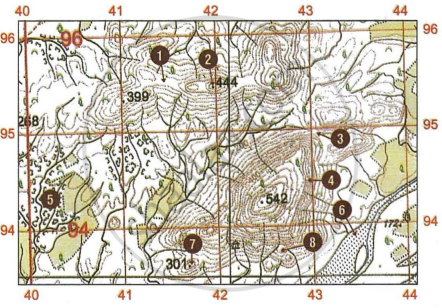
Match the following physical features with the numbers on the extract of the toposheet:
- Dry river bed
- Saddle
- Steep Slope
- Pass
- Gap
- Gully
- Knoll
- Hill

Topo-sheets
Study the extract of the Survey of India and answer the following questions [Eastings 25-35, Northings 89-99]:

- (a) Give the four-figure grid reference of the settlement of Nilpur.
(b) Give the six-figure grid reference of Chhatri north of Vadavas. - (a) State the compass direction of the settlement of Ratanpur from the settlement of Marwada.
(b) State two advantages that Dantiwada, south of river Banas has over other settlements in the region in the given map extract. - (a) What are the brown dotted clusters in the southern part of the given map extract? Also state what the letters Dep in the same area indicate.
(b) Explain why some of the streams in the south-eastern part of the given map extract do not join the main river? Name the settlement where these streams can be seen. - (a) What is the general pattern of human habitation (settlement) in the given map extract?
(b) Measure the length of the aqueduct in metres from the point whose six-figure grid reference is 261920 to the point whose six-figure grid reference is 274929. - (a) Name the two types of dams shown in the given map extract.
(b) How does the drainage pattern in grid square 2698 differ from the pattern of streams in grid square 2697?
Study the extract of the Survey of India map and answer the following questions:
- (a) Give the four-figure grid reference of the settlement at lodpa.
(b) Give the six-figure grid reference of the spot height ·172. - (a) Identify the features from the conventional signs, the six-figure grid reference of which is 332963.
(b) Give the compass direction of Ramsida from Nandotra. - (a) Measure the length in kilometres of the masonry dam on the main river in the given map extract.
(b) Identify the type of road that runs from the Police Station at Dantiwada up to the settlement at Nandotra (Brahmanvas) (grid square 2794). For which purpose is this road used? - (a) Calculate the area of the region in sq. km, enclosed within the Eastings 25-35 and Northings 91 to 95.
(b) State the three types of roads seen in the given map extract. What do they reflect on the type of settlements in the region in the given map extract? - (a) State the difference in the pattern of settlement at Dantiwada on the right bank of the main river and the one on the left bank of it.
(b) What is the main form of irrigation in the area north of Sarod Nala? From what can you infer this source of irrigation?

Study the extract of the Survey of India Map and answer the following questions [Eastings 61-71, Northings 13-23]:
- (a) Give the four-figure grid reference of the perennial well to the north of Jhamar.
(b) Give the six-figure grid reference of the temple at Shri Vashisht Ashram. - (a) What is the area in kilometres of the forested region enclosed within Eastings 66 and 71 and Northings 15 and 19?
(b) What is the compass direction of Hanumanji ka Mandir from Gautam Maharishi Mandir? - (a) What does the word 'Falls 15m' in grid square 6718 indicate? Explain how these Falls are formed.
(b) What is the distance, in kilometres along the metalled road from distance stone 16 (grid square 6313) to the canal in grid square 6413? - (a) Abu is a big settlement with high water demand. From where does it get its main water supply? Give two reasons to support your answer.
(b) What is indicated by the large number and the closeness of the contour lines in the given map extract? - (a) What do the broken black lines in grid square 6221 indicate? How are they formed?
(b) Why are there no settlements except Abu in the given map extract? Give a reason to support your answer.
Study the extract of the Survey of India Map and answer the following questions [Eastings 61-71, Northings 13-23]:
- (a) Give the four-figure grid reference of the settlement of Deoli.
(b) Give the six-figure grid reference of the surveyed tree 277. - (a) What is the area in kilometres of the administrative area enclose within the Eastings 68 and 70 and the Northings 21 and 23?
(b) What is the compass direction of St. Mary's High School from Gautam Maharishi Mandir? - (a) What is the distance in kilometres along the metalled road from Hanumanji ka Mandir till it merges with another metalled road in grid square 6820.
(b) How can you conclude that Abu is an administrative area? Give a reason to support your answer. - (a) What is meant by ·501 in grid square 6421.
(b) How can you conclude that the yellow area in the south-east corner of the map is an agricultural land? - (a) How is the drainage pattern in grid square 6220 differ from the I drainage pattern in grid square 6817?
(b) What is the difference between the slope in grid square 6320 and the one in 6622? Give a reason to support your answer.
Solutions for 4: Map Reading and Interpretation
![Morning Star solutions for Total Geography [English] Class 10 chapter 4 - Map Reading and Interpretation Morning Star solutions for Total Geography [English] Class 10 chapter 4 - Map Reading and Interpretation - Shaalaa.com](/images/total-geography-english-class-10_6:50f152b897f542b0866f1c409a32fe3b.jpg)
Morning Star solutions for Total Geography [English] Class 10 chapter 4 - Map Reading and Interpretation
Shaalaa.com has the CISCE Mathematics Total Geography [English] Class 10 CISCE solutions in a manner that help students grasp basic concepts better and faster. The detailed, step-by-step solutions will help you understand the concepts better and clarify any confusion. Morning Star solutions for Mathematics Total Geography [English] Class 10 CISCE 4 (Map Reading and Interpretation) include all questions with answers and detailed explanations. This will clear students' doubts about questions and improve their application skills while preparing for board exams.
Further, we at Shaalaa.com provide such solutions so students can prepare for written exams. Morning Star textbook solutions can be a core help for self-study and provide excellent self-help guidance for students.
Concepts covered in Total Geography [English] Class 10 chapter 4 Map Reading and Interpretation are Map Reading, Primary Information or Marginal Information, Relief Features, Relationship Between Physical Features and Human Activities, Analysis of Topo-sheet No. G43S7, Analysis of Topo-sheet No. G43S10.
Using Morning Star Total Geography [English] Class 10 solutions Map Reading and Interpretation exercise by students is an easy way to prepare for the exams, as they involve solutions arranged chapter-wise and also page-wise. The questions involved in Morning Star Solutions are essential questions that can be asked in the final exam. Maximum CISCE Total Geography [English] Class 10 students prefer Morning Star Textbook Solutions to score more in exams.
Get the free view of Chapter 4, Map Reading and Interpretation Total Geography [English] Class 10 additional questions for Mathematics Total Geography [English] Class 10 CISCE, and you can use Shaalaa.com to keep it handy for your exam preparation.
