Advertisements
Advertisements
Question
Discuss how weather maps and charts are prepared.
Solution
Weather Maps: A weather map is the representation of weather phenomena of the earth or a part of it on a flat surface. It depicts conditions associated with different weather elements such as temperature, rainfall, sunshine and cloudiness, direction and velocity of winds, etc. on a particular day. These observations being taken at fixed hours are transmitted by code to the forecasting stations. The central office keeps a record of the observations, which forms the basis for making a weather map. The upper air observations which are procured from hill stations, airplanes, pilot balloons, etc. are plotted separately.
Indian Meteorological Department is getting the weather maps and charts prepared regularly. Meteorological observatories transmit the data to the Central Observatory at Pune twice a day. Data is also collected on ships plying on the Indian seas. A good progress has been made in the field of weather forecasting and observation with the establishment of weather observatories in Antarctica, the International Indian Ocean Expedition, and the launching of rockets and weather satellites.
APPEARS IN
RELATED QUESTIONS
The primary tool for weather forecasting is______.
What is a weather chart?
How weather maps and charts are useful to us?
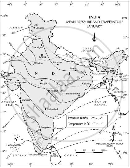
Study the following figures and answer the following questions.
- Which seasons are shown in these maps?
- What is the value of the highest isobar in Figure A and through which part of the country does it pass?
- What are the values of the highest and the lowest isobars in Figure B and where are they located?
- What are the patterns of temperature distribution in both the maps?
- In which parts do you see the highest and the lowest mean temperature in Figure A?
- What relationship do you see between the distribution of temperature and pressure in both the maps?
Figure A
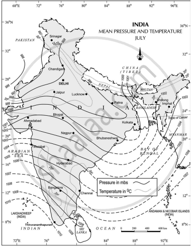
Figure B