Advertisements
Chapters
2: Map Scale
3: Latitude, Longitude and Time
4: Map Projections
5: Topographical Maps
6: Introduction To Aerial Photographs
7: Introduction To Remote Sensing
▶ 8: Weather Instruments, Maps and Charts
![NCERT solutions for Practical Work in Geography [English] chapter 8 - Weather Instruments, Maps and Charts - Shaalaa.com](/images/practical-work-in-geography-english_6:926c1c575b374fb4a77ce82f6642f634.jpg "NCERT solutions for Practical Work in Geography [English] chapter 8 - Weather Instruments, Maps and Charts")
Advertisements
Solutions for Chapter 8: Weather Instruments, Maps and Charts
Below listed, you can find solutions for Chapter 8 of CBSE NCERT for Practical Work in Geography [English].
NCERT solutions for Practical Work in Geography [English] 8 Weather Instruments, Maps and Charts Exercises [Pages 122 - 123]
Choose the right answer from the four alternatives given below.
Which department prepares the weather map of India for each day?
The World Meteorological Organisation
The Indian Meteorological Department
The Survey of India
None of these
Which two liquids are used in maximum and minimum thermometers?
Mercury and water
Water and alcohol
Mercury and alcohol
None of these
Lines connecting the places of equal pressure are called______.
Isobars
Isohyets
Isotherms
Isohels
The primary tool for weather forecasting is______.
Thermometer
Barometer
Maps
Weather charts
If there is more humidity in the air, the difference between the readings of a dry bulb and a wet-bulb will be______.
Less
More
Equal
None of these
Answer the following questions in about 30 words.
What are the basic elements of weather?
What is a weather chart?
Which instruments are normally available in Class-I observatory to measure the weather phenomena?
What are Isotherms?
Which meteorological symbols are used to mark the following on a weather map?
- Rain
- Mist
- Sunshine
- Lightning
- Overcast Sky
Answer the following question in not more than 125 words.
Discuss how weather maps and charts are prepared.
How weather maps and charts are useful to us?
NCERT solutions for Practical Work in Geography [English] 8 Weather Instruments, Maps and Charts MAP READING [Page 123]
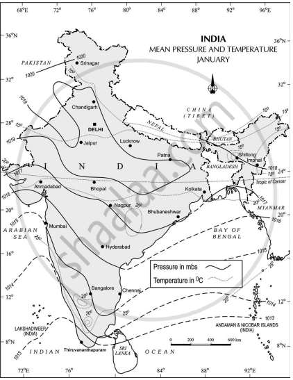
Study the following figures and answer the following questions.
- Which seasons are shown in these maps?
- What is the value of the highest isobar in Figure A and through which part of the country does it pass?
- What are the values of the highest and the lowest isobars in Figure B and where are they located?
- What are the patterns of temperature distribution in both the maps?
- In which parts do you see the highest and the lowest mean temperature in Figure A?
- What relationship do you see between the distribution of temperature and pressure in both the maps?
Figure A
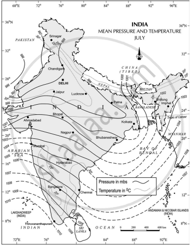
Figure B
Solutions for 8: Weather Instruments, Maps and Charts
NCERT solutions for Practical Work in Geography [English] chapter 8 - Weather Instruments, Maps and Charts
Shaalaa.com has the CBSE Mathematics Practical Work in Geography [English] CBSE solutions in a manner that help students grasp basic concepts better and faster. The detailed, step-by-step solutions will help you understand the concepts better and clarify any confusion. NCERT solutions for Mathematics Practical Work in Geography [English] CBSE 8 (Weather Instruments, Maps and Charts) include all questions with answers and detailed explanations. This will clear students' doubts about questions and improve their application skills while preparing for board exams.
Further, we at Shaalaa.com provide such solutions so students can prepare for written exams. NCERT textbook solutions can be a core help for self-study and provide excellent self-help guidance for students.
Concepts covered in Practical Work in Geography [English] chapter 8 Weather Instruments, Maps and Charts are Introduction to Weather Instruments, Maps and Charts, Weather Observations, Surface Observatories, Space-based Observations, Weather Instruments, Weather Maps and Charts, Weather Symbols.
Using NCERT Practical Work in Geography [English] solutions Weather Instruments, Maps and Charts exercise by students is an easy way to prepare for the exams, as they involve solutions arranged chapter-wise and also page-wise. The questions involved in NCERT Solutions are essential questions that can be asked in the final exam. Maximum CBSE Practical Work in Geography [English] students prefer NCERT Textbook Solutions to score more in exams.
Get the free view of Chapter 8, Weather Instruments, Maps and Charts Practical Work in Geography [English] additional questions for Mathematics Practical Work in Geography [English] CBSE, and you can use Shaalaa.com to keep it handy for your exam preparation.
