Advertisements
Chapters
2: The Sun, the Moon and the Earth
3: Tides
4: Air Pressure
5: Winds
6: Natural Regions
7: Soils
8: How Seasons Occur - Part 2
9: Agriculture
10: Human Settlements
▶ 11: Contour Maps and Landforms
![Balbharati solutions for Geography (Social Science) [English] 7 Standard chapter 11 - Contour Maps and Landforms Balbharati solutions for Geography (Social Science) [English] 7 Standard chapter 11 - Contour Maps and Landforms - Shaalaa.com](/images/geography-social-science-english-7-standard_6:f92fa167f106463d84bcfc1440408f8d.jpg)
Advertisements
Solutions for Chapter 11: Contour Maps and Landforms
Below listed, you can find solutions for Chapter 11 of Maharashtra State Board Balbharati for Geography (Social Science) [English] 7 Standard.
Balbharati solutions for Geography (Social Science) [English] 7 Standard 11 Contour Maps and Landforms Acitivity [Pages 72 - 73]
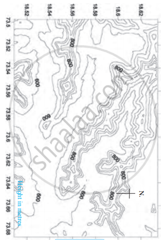
Observe the given figure and answer the following questions.

- What is the general direction of the ranges shown in the map?
- Towards which direction is the flat land located in the map?
- What are the maximum and minimum values of the lines in the map?
- What do these values indicate?
- Do you find any similarities in the map and the model in Figure? What are those?
- Which figure gives us more information and what is that information?
- Is there any similarity between this map and the sketch map of the potato hill?
- What all do you see in the map?
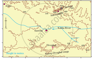
Observe this model and the map figure a and b given below it and answer the following questions.
- In which direction does fort Purandar lie?
- What is the direction of the flow of the river Karha?
- In which parts are the hill ranges not observed?
- Which part of the map is not seen in the model? Why?
- In which direction does the altitude of the Katraj-Diveghat range decrease?
- In which direction are higher hill ranges located?
Balbharati solutions for Geography (Social Science) [English] 7 Standard 11 Contour Maps and Landforms Exercises [Page 74]
How can the distribution of the height and landforms in a region be shown?
To whom are the contour maps useful?
What do you understand by observing contour lines?
How will a contour map be useful for a farmer?
If the contour lines are closer to each other, the slope is ______.
The contour lines on the map represent ______.
The slope can be understood from the distance between the ______.
If the distance between two contour lines is more, the ______ is gentle.
Identify the landforms in the following map.

Solutions for 11: Contour Maps and Landforms
![Balbharati solutions for Geography (Social Science) [English] 7 Standard chapter 11 - Contour Maps and Landforms Balbharati solutions for Geography (Social Science) [English] 7 Standard chapter 11 - Contour Maps and Landforms - Shaalaa.com](/images/geography-social-science-english-7-standard_6:f92fa167f106463d84bcfc1440408f8d.jpg)
Balbharati solutions for Geography (Social Science) [English] 7 Standard chapter 11 - Contour Maps and Landforms
Shaalaa.com has the Maharashtra State Board Mathematics Geography (Social Science) [English] 7 Standard Maharashtra State Board solutions in a manner that help students grasp basic concepts better and faster. The detailed, step-by-step solutions will help you understand the concepts better and clarify any confusion. Balbharati solutions for Mathematics Geography (Social Science) [English] 7 Standard Maharashtra State Board 11 (Contour Maps and Landforms) include all questions with answers and detailed explanations. This will clear students' doubts about questions and improve their application skills while preparing for board exams.
Further, we at Shaalaa.com provide such solutions so students can prepare for written exams. Balbharati textbook solutions can be a core help for self-study and provide excellent self-help guidance for students.
Concepts covered in Geography (Social Science) [English] 7 Standard chapter 11 Contour Maps and Landforms are Contour Maps and Landforms.
Using Balbharati Geography (Social Science) [English] 7 Standard solutions Contour Maps and Landforms exercise by students is an easy way to prepare for the exams, as they involve solutions arranged chapter-wise and also page-wise. The questions involved in Balbharati Solutions are essential questions that can be asked in the final exam. Maximum Maharashtra State Board Geography (Social Science) [English] 7 Standard students prefer Balbharati Textbook Solutions to score more in exams.
Get the free view of Chapter 11, Contour Maps and Landforms Geography (Social Science) [English] 7 Standard additional questions for Mathematics Geography (Social Science) [English] 7 Standard Maharashtra State Board, and you can use Shaalaa.com to keep it handy for your exam preparation.


