Advertisements
Chapters
2: Population
3: Migration
4: Urbanization
5: Natural and Man-made Disasters with Case Studies
6: Disaster Management
▶ 7: Asia: Location, Extent, Political and Physical Features
8: Asia: Climate and Natural Vegetation
9: India: Location, Extent, Political and Physical Features
10: India: Climate, Natural Vegetation, Forests and Wildlife
11: Human Resources in India
![Oxford University Press solutions for Voyage Geography [English] Class 8 chapter 7 - Asia: Location, Extent, Political and Physical Features - Shaalaa.com](/images/voyage-geography-english-class-8_6:8252e9b8eb0c48bba3b0177d4ba41329.jpg "Oxford University Press solutions for Voyage Geography [English] Class 8 chapter 7 - Asia: Location, Extent, Political and Physical Features")
Advertisements
Solutions for Chapter 7: Asia: Location, Extent, Political and Physical Features
Below listed, you can find solutions for Chapter 7 of CISCE Oxford University Press for Voyage Geography [English] Class 8.
Oxford University Press solutions for Voyage Geography [English] Class 8 7 Asia: Location, Extent, Political and Physical Features Fill in the blanks
Fill in the blank:
A mountain range in South-west Asia that separates Asia from Europe: ____________
Fill in the blank:
I am a plain formed by the rivers Ob, Yenisei, and Lena: ________________.
Fill in the blank:
An area of inland drainage into which the Amu Darya and, Syr Darya drain: ________.
Fill in the blank:
I am a small zone from which several mountain ranges appear to radiate out: _________.
Fill in the blank:
A plateau that lies between the Alborz and Zagros mountain ranges: ___________
Oxford University Press solutions for Voyage Geography [English] Class 8 7 Asia: Location, Extent, Political and Physical Features Match the Columns
Match the following:
| Column A | Column B |
| 1. Population of Asia | a. Manchurian Plain |
| 2. Countries in Asia | b. Plateau of Tibet |
| 3. Marshy lowlands | c. 4.43 billion people |
| 4. Inter-montane plateau | d. 48 |
| 5. River Amur | e. Great Siberian Plain |
Oxford University Press solutions for Voyage Geography [English] Class 8 7 Asia: Location, Extent, Political and Physical Features True or False
State whether the following is true or false:
Together with Europe, Asia is often referred to as Eurasia.
True
False
State whether the following is true or false:
Most of the Asian countries gained independence only after World War I.
True
False
State whether the following is true or false:
Three rivers which flow northwards into the Arctic Ocean are the Ganga, the Brahmaputra, and the Yamuna.
True
False
State whether the following is true or false:
The Karakoram Range is a short-range, which extends south-eastwards from the Pamir Knot between the Kunlun and the Himalayas.
True
False
State whether the following is true or false:
The Deccan Plateau of India lies between the Western Ghats and the Eastern Ghats.
True
False
Oxford University Press solutions for Voyage Geography [English] Class 8 7 Asia: Location, Extent, Political and Physical Features Answer the following questions in brief
Answer the following question in brief:
Name the geographical features that border Asia in the north, south, east, and west.
Answer the following question in brief:
What do you understand by the term ‘archipelago ? Give two examples from the Pacific Ocean.
Answer the following question in brief:
Name the rivers of the Great Siberian Plain.
Answer the following question in brief:
What kind of plateau is the Plateau of Tibet?
Answer the following question in brief:
In which country of Asia are the Mesopotamian plains situated?
Oxford University Press solutions for Voyage Geography [English] Class 8 7 Asia: Location, Extent, Political and Physical Features Answer the following questions in detail
Answer the following question in detail:
Describe the location of Asia.
Answer the following question in detail:
Describe the Northern Lowlands of Asia.
Explain why the Pamir Knot is called so. Write briefly about the mountain ranges that radiate from the Pamir Knot.
Answer the following question in detail:
Write briefly about the Arabian Plateau and the Deccan Plateau.
Answer the following question in detail:
Describe the river valleys of Asia.
Oxford University Press solutions for Voyage Geography [English] Class 8 7 Asia: Location, Extent, Political and Physical Features Picture study
The mountain peak seen in the picture is the highest peak in the world.
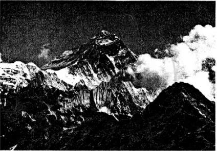
What is the height of this peak?
The mountain peak seen in the picture is the highest peak in the world.
In which mountain range does it lie?
Oxford University Press solutions for Voyage Geography [English] Class 8 7 Asia: Location, Extent, Political and Physical Features Map study
On an outline map of Asia, mark and name the following:
- Rivers — Amur, Ob, Chang Jiang
- Gulfs — the Persian Gulf, Gulf of Martaban
- Straits — Bering Strait, Strait of Malacca
- Seas — Arabian Sea, Caspian Sea, Sea of Japan
- Oceans — Arctic, Pacific, Indian
- Mountain ranges — Himalayas, Urals, Hindukush
- Write ROOF OF THE WORLD and GREAT SIBERIAN PLAIN in appropriate places on the map.
Oxford University Press solutions for Voyage Geography [English] Class 8 7 Asia: Location, Extent, Political and Physical Features Extra Questions
What do you mean by Eurasia?
What are perennial rivers?
Name the five physical regions of Asia
Which mountain range has some of the world’s highest peaks?
Name the plateaux (plural of the plateau) of the Southern Plateaux of Asia.
Name the rivers that have built the Great River Valleys of Asia.
Write a note on the Island Chains of Asia.
Which is the largest and the smallest country in Asia?
Name the following (in Asia):
Most industrialized country
Name the following (in Asia):
Highest elevation
Name the following (in Asia):
Highest Plateau
Name the following (in Asia):
Lowest point
Name the following (in Asia):
Deepest sea
Name the following (in Asia):
Deepest lake
Name the following (in Asia):
Longest strait
Name the following (in Asia):
Coldest Place
Name the following (in Asia):
Warmest place
Name the following (in Asia):
Number of countries in Asia
What are the six regional divisions of Asia?
Name some important cities in East Asia.
Which are the two main rivers of Central Asia and why are they important?
Write a short note on South Asia.
Why is West Asia not densely populated?
Why is the Plateau of Tibet called the ‘Roof of the World’?
Which is the highest and the second-highest peak in the world and where are they situated?
Name few glaciers found in Himalayas and Karakoram range of mountains.
Name few passes in the Central Fold Mountains and Inter – Montane Plateaux which allow the movements of goods and people across the mountains.
Why did the Arabian Plateau become important to the rest of the world?
Why are the fertile river valleys and plains of Asia and such as the Mesopotamian Plains, the Indo-Gangetic Plains, and the Great Plains of China called the cradles of civilization?
What makes Asia a continent of contrasts?
Fill in the blanks:
Asia lies wholly in the _______ and ________ hemispheres.
Fill in the blank:
Together with Europe, Asia is called ______.
Fill in the blanks:
______Ocean lies to the east and _______Ocean to the south of Asia.
Fill in the blank:
There is a time difference about ____hours between the Anatolian Plateau (Asia Minor) in the west and the Pacific Coast in the east of Asia.
Fill in the blank:
There are ______ independent countries in Asia.
Fill in the blank:
_____ is the largest continent in the world..
Fill in the blanks:
Asia occupies ______ of the total land area and _______ of the total population of the world.
Fill in the blank:
USSR broke up into several independent republics in 1991, some of which are in ______ and some in Asia now.
Fill in the blank:
North Asia is divided by a long mountain range known as the ___________ Mountains.
Fill in the blank:
Siberia lies in the _________ of Ural Mountains.
Fill in the blanks:
The two main rivers of Central Asia are the ________ and the __________.
Fill in the blank:
______ Asia is the most densely populated region in the world.
Fill in the blank:
___________________ are the world’s greatest continuous plains
Fill in the blank:
The Himalayas emerge from the ______________ in south-east direction.
Fill in the blank:
___________, the world’s highest peak lies on the border between Nepal and the Tibet Autonomous Region of China.
Fill in the blank:
The ___________ Plateau is a dry plateau as it is in the region of low rainfall and no rivers.
Fill in the blank:
____________ is also called as the land of five rivers.
Fill in the blank:
The _____________ is Asia’s longest river.
Fill in the blank:
The Lakshadweep Islands and the Andaman and Nicobar Islands are in _________ Asia.
Fill in the blank:
The ________ is the smallest country in Asia.
Fill in the blank:
The zone from where the mountain ranges appear to radiate outwards in different directions in the Central Fold mountains in Asia is called __________.
Solutions for 7: Asia: Location, Extent, Political and Physical Features
Oxford University Press solutions for Voyage Geography [English] Class 8 chapter 7 - Asia: Location, Extent, Political and Physical Features
Shaalaa.com has the CISCE Mathematics Voyage Geography [English] Class 8 CISCE solutions in a manner that help students grasp basic concepts better and faster. The detailed, step-by-step solutions will help you understand the concepts better and clarify any confusion. Oxford University Press solutions for Mathematics Voyage Geography [English] Class 8 CISCE 7 (Asia: Location, Extent, Political and Physical Features) include all questions with answers and detailed explanations. This will clear students' doubts about questions and improve their application skills while preparing for board exams.
Further, we at Shaalaa.com provide such solutions so students can prepare for written exams. Oxford University Press textbook solutions can be a core help for self-study and provide excellent self-help guidance for students.
Concepts covered in Voyage Geography [English] Class 8 chapter 7 Asia: Location, Extent, Political and Physical Features are Asia: Location and Extent, Parts of Asia, Asia Physiography, Asia: Climate, Asia: Natural Vegetation and Wildlife.
Using Oxford University Press Voyage Geography [English] Class 8 solutions Asia: Location, Extent, Political and Physical Features exercise by students is an easy way to prepare for the exams, as they involve solutions arranged chapter-wise and also page-wise. The questions involved in Oxford University Press Solutions are essential questions that can be asked in the final exam. Maximum CISCE Voyage Geography [English] Class 8 students prefer Oxford University Press Textbook Solutions to score more in exams.
Get the free view of Chapter 7, Asia: Location, Extent, Political and Physical Features Voyage Geography [English] Class 8 additional questions for Mathematics Voyage Geography [English] Class 8 CISCE, and you can use Shaalaa.com to keep it handy for your exam preparation.
